| NEW CASTLE-HENRY CO. MUNI. NEW CASTLE IN |
| |
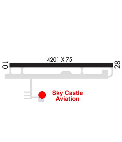
| Lat: N 3952.6 Long: W 08519.5 Elev: 1090 Var: +06 Longest Runway: 4201 | ||
| CTAF: 123.05 | ||
| |||||||||||||||||||||||||||||||||||||||||||||||||||||||||||||
| |||||||||||||||||||||||||||||||||||||||||||||||||||||||||||||
| Rwy | Rwy | |||||||
| 4201x75 | 4201' | 4201x75 | 4201' | |||||
| Runway ID | Single Wheel | Double Wheel | Double Tandem Wheel | Dual Double Wheel |
| 10/28 | N/A | N/A | N/A | N/A |
| These numbers are Advisory and are not limits. The Airport Manager should have more accurate Weight Limits | ||||
 Airport Diagram might not be current. | |
| Facility Name: | NEW CASTLE HENRY COUNTY MARLATT FLD |
| City Name: | NEW CASTLE |
| County: | HENRY |
| State abbrev: | IN |
| State Name: | INDIANA |
| Ownership: | PUBLICLY OWNED |
| Use: | OPEN TO THE PUBLIC |
| Owner's Name: | NEW CASTLE/HENRY COUNTY; AIRPORT OWNED BY MR. MARLATT, RUNWAY OWNED BY CITY OF NEW CASTLE, HENRY CO. |
| Address: | 2912 E. CO. RD. 400 S. |
| NEW CASTLE, IN 47362 | |
| Owner's Phone: | 765-529-7903 |
| Manager's Name: | JOHN MARLATT |
| Address: | 2912 E. CO. RD. 400 S. |
| NEW CASTLE, IN 47362 | |
| Phone: | 765-529-7903; OR 765-529-7909. |
| FAA Region: | GREAT LAKES |
| FAA Field Office: | CHI |
| Date | Sunrise | Sunset |
|---|---|---|
| 09/24/21 Friday | 7:31 | 19:35 |
| 09/25/21 Saturday | 7:31 | 19:34 |
| 09/26/21 Sunday | 7:32 | 19:32 |
| 09/27/21 Monday | 7:33 | 19:31 |
| 09/28/21 Tuesday | 7:34 | 19:29 |
| 09/29/21 Wednesday | 7:35 | 19:27 |
| 09/30/21 Thursday | 7:36 | 19:26 |
| 10/01/21 Friday | 7:37 | 19:24 |
| 10/02/21 Saturday | 7:38 | 19:22 |
| 10/03/21 Sunday | 7:39 | 19:21 |
| 10/04/21 Monday | 7:40 | 19:19 |
| 10/05/21 Tuesday | 7:41 | 19:18 |
| 10/06/21 Wednesday | 7:42 | 19:16 |
| 10/07/21 Thursday | 7:43 | 19:14 |
| Airport Attendance Schedule | 7 Days A Week 0800-1800; FOR FUEL WHEN ARPT UNATNDD PHONE 765-332-2969. |
| Airport Status | OPERATIONAL (This Status can change at any time - please check NOTAMS) |
| Airport Lighting Schedule | MIRL RY 10/28 PRESET ON LOW INTST; TO INCR INTST & ACTVT PAPI RYS 10 & 28; REIL RYS 10 & 28 - CTAF. |
| Airport Storage Available | Tie Downs, Hanger |
| Extra Services Available | Air Freight, Cargo Handling, Charter, Flight Instruction, Aircraft Rental |
| Wind Indicator | YES - (lighted) |
| Control Tower | NO |
| CTAF Frequency | 123.050 |
| Unicom Frequency | 123.050 |
| Rotating Beacon Color | CLEAR-GREEN (Light Land Airport) |
| Segmented Circle | NO |
| Landing Fee | NO |
| Airport Inspected | STATE - performed by STATE AERONAUTICAL PERSONNEL |
| Inspection Date | 09/01/2019 |
| Type of Fuel Available | Grade 100LL, JET A (freeze point -40C) |
| Airframe Repair Service | MINOR |
| Power Plant Repair Service | MINOR |
| Latitude | N3952.6 |
| Longitude | W08519.5 (ESTIMATED) |
| Arpt Elevation | 1090ft (SURVEYED) |
| Magnetic Variation | 06W |
| 4 miles SE | of NEW CASTLE |
| Traffic Pattern Altitude | |
| Sectional Chart | ST LOUIS |
| Operations (Reported) | Yearly | Avg. Daily |
|---|---|---|
| General Aviation Transient | 362 | 1 |
| General Aviation Local | 1809 | 5 |
| Air Taxi | 90 | 0 |
| Commerical | 0 | 0 |
| Commuter | 0 | 0 |
| Military | 0 | 0 |
| Aircraft based on Field | |
|---|---|
| General Aviation Singles | 14 |
| General Aviation Multi | 0 |
| Jet Aircraft | 0 |
| General Aviation Helicopters | 0 |
| Military Aircraft | 0 |
| Gliders | 0 |
| Ultralights | 0 |
| FSS on field | NO |
| FSS tie-in | TERRE HAUTE |
| FSS Phone | 1-800-WX-BRIEF |
| Who issues Notams | HUF |
| Notam D service at airport | YES |
| ARTCC Name | INDIANAPOLIS |
| Airport Certification | |
| Aircraft Rescue & Firefighting Index | None |
| Airport of Entry | No |
| Custom Landing Rights | No |
| Joint Civil/Military | No |
| Military Landing rights | No |
| NATIONAL PLAN OF INTEGRATED AIRPORT SYSTEMS (NPIAS) |
| FOR CD CTC INDIANAPOLIS APCH AT 317-227-5743. |
Airport Communications & Frequencies:
| ||||||||||||||
| Runway: 10 | Runway: 28 | ||
| Mag heading: | 96° | Mag heading: | 276° |
| Rwy Slope: | .24% Up | Rwy Slope: | -.24% Down |
| Approach: | Approach: | ||
| Pattern: | Left Traffic | Pattern: | Left Traffic |
| Markings: | NONPRECISION INSTRUMENT | Markings: | NONPRECISION INSTRUMENT |
| Marking Condition: | GOOD | Marking Condition: | GOOD |
| Arresting Dev: | Arresting Dev: | ||
| Lat & Long: | N3952.6 W08520.0 | Lat. & Long.: | N3952.6 W08519.1 |
| Elev: | 1080.1 ft. MSL | Elev: | 1090.1 ft. MSL |
| TCH: | 46 ft. AGL | TCH: | 44 ft. AGL |
| Visual Glide Path: | 3.00 degrees | Visual Glide Path: | 3.00 degrees |
| Displaced Threshold: | No | Displaced Threshold: | No |
| Touchdown Zone: | YES | Touchdown Zone: | YES |
| Touchdown Elev.: | 1088.5 feet | Touchdown Elev.: | 1090.2 feet |
| Visual Glide Slope: | 2-Light PAPI on LEFT side of Runway | Visual Glide Slope: | 2-Light PAPI on LEFT side of Runway |
| RVR Equipment: | RVR Equipment: | ||
| RVV Equipment: | NO | RVV Equipment: | NO |
| Approach Lights: | Approach Lights: | ||
| REIL: | YES | REIL: | YES |
| Centerline Lights: | NO | Centerline Lights: | NO |
| Touchdown lights: | NO | Touchdown lights: | NO |
| Runway Category: | Runway Category: | ||
| Declared Distances: | Declared Distances: | ||
| Obstructions: | Obstructions: | CROPS | |
| Marked: | Marked: | NOT Marked/Lighted | |
| Clearance slope: | Clearance slope: | 1:1 | |
| Obstruction height: | Obstruction height: | 10 feet AGL | |
| Dist. from runway: | Dist. from runway: | 210 feet | |
| Centerline offset: | Centerline offset: | ||
| Comments: | Comments: |
Thanks for using FltPlan.com
all rights reserved © 1999-2021 by Flight Plan LLC