
| TUNICA MUNI TUNICA MS |
| |
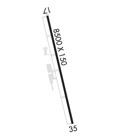
| Lat: N 3441.1 Long: W 09020.9 Elev: 194 Var: -00 Longest Runway: 8500 | ||
| Clr Del: 118.9 AWOS: 118.07 CTAF: 123.0 | ||
| ||||||||||||||||||||||||||||||||||||||||||||
| ||||||||||||||||||||||||||||||||||||||||||||
| ||||||||||||||||||||||||||||||||||||||||||||
| Rwy | Rwy | |||||||
| 8500x150 | 8500' | 8500x150 | 8500' | 110.95 - 347° | ||||
| Runway ID | Single Wheel | Double Wheel | Double Tandem Wheel | Dual Double Wheel |
| 17/35 | 94,000 | 215,000 | 460,000 | 720,000 |
| These numbers are Advisory and are not limits. The Airport Manager should have more accurate Weight Limits | ||||
 Airport Diagram might not be current. | |
| Facility Name: | TUNICA MUNI |
| City Name: | TUNICA |
| County: | TUNICA |
| State abbrev: | MS |
| State Name: | MISSISSIPPI |
| Ownership: | PUBLICLY OWNED |
| Use: | OPEN TO THE PUBLIC |
| Owner's Name: | TUNICA COUNTY AIRPORT COMMISSION |
| Address: | PO BOX 158 |
| TUNICA, MS 38676 | |
| Owner's Phone: | 662-357-7320 |
| Manager's Name: | MARIE WARNER |
| Address: | 209 S ARPT BLVD-PO BOX 158 |
| TUNICA, MS 38676 | |
| Phone: | 662-357-7320 |
| FAA Region: | SOUTHERN |
| FAA Field Office: | JAN |
| Date | Sunrise | Sunset |
|---|---|---|
| 06/12/26 Friday | 5:48 | 20:15 |
| 06/13/26 Saturday | 5:48 | 20:15 |
| 06/14/26 Sunday | 5:48 | 20:16 |
| 06/15/26 Monday | 5:48 | 20:16 |
| 06/16/26 Tuesday | 5:48 | 20:16 |
| 06/17/26 Wednesday | 5:48 | 20:17 |
| 06/18/26 Thursday | 5:48 | 20:17 |
| 06/19/26 Friday | 5:48 | 20:17 |
| 06/20/26 Saturday | 5:48 | 20:17 |
| 06/21/26 Sunday | 5:49 | 20:18 |
| 06/22/26 Monday | 5:49 | 20:18 |
| 06/23/26 Tuesday | 5:49 | 20:18 |
| 06/24/26 Wednesday | 5:49 | 20:18 |
| 06/25/26 Thursday | 5:50 | 20:18 |
| Airport Attendance Schedule | 7 Days A Week 0600-2100; AFT HR FUEL - AMGR. |
| Airport Status | OPERATIONAL (This Status can change at any time - please check NOTAMS) |
| Airport Lighting Schedule | ACTVT MALSR RWY 35; REIL RWY 17; HIRL RWY 17/35 - CTAF. |
| Airport Storage Available | Tie Downs, Hanger |
| Extra Services Available | Crop Dusting |
| Wind Indicator | YES - (lighted) |
| Control Tower | NO |
| CTAF Frequency | 123.000 |
| Unicom Frequency | 123.000 |
| Rotating Beacon Color | WG |
| Segmented Circle | YES |
| Landing Fee | NO |
| Airport Inspected | STATE - performed by FAA AIRPORTS FIELD PERSONNEL |
| Inspection Date | 03/16/2021 |
| Type of Fuel Available | Grade 100LL, JET A (freeze point -40C) |
| Airframe Repair Service | MAJOR |
| Power Plant Repair Service | MAJOR |
| Latitude | N3441.1 |
| Longitude | W09020.9 (ESTIMATED) |
| Arpt Elevation | 194ft (SURVEYED) |
| Magnetic Variation | 00E |
| 1 miles E | of TUNICA |
| Traffic Pattern Altitude | |
| Sectional Chart | MEMPHIS |
| Operations (Reported) | Yearly | Avg. Daily |
|---|---|---|
| General Aviation Transient | 0 | 0 |
| General Aviation Local | 0 | 0 |
| Air Taxi | 0 | 0 |
| Commerical | 0 | 0 |
| Commuter | 0 | 0 |
| Military | 0 | 0 |
| Aircraft based on Field | |
|---|---|
| General Aviation Singles | 0 |
| General Aviation Multi | 0 |
| Jet Aircraft | 0 |
| General Aviation Helicopters | 0 |
| Military Aircraft | 0 |
| Gliders | 0 |
| Ultralights | 0 |
| FSS on field | NO |
| FSS tie-in | GREENWOOD |
| FSS Phone | 1-800-WX-BRIEF |
| Who issues Notams | UTA |
| Notam D service at airport | YES |
| ARTCC Name | MEMPHIS |
| Airport Certification | CLSD TO SKED ACR OPS WITH MORE THAN 9 PAX SEATS & UNSKED ACR OPS WITH MORE THAN 30 PAX SEATS. |
| Aircraft Rescue & Firefighting Index | None |
| Airport of Entry | No |
| Custom Landing Rights | No |
| Joint Civil/Military | No |
| Military Landing rights | No |
| NATIONAL PLAN OF INTEGRATED AIRPORT SYSTEMS (NPIAS) |
| GRANT AGREEMENTS UNDER FAAP/ADAP/AIP |
| ASSURANCES PURSUANT TO TITLE VI, CIVIL RIGHTS ACT OF 1964 |
| 24 HR PPR COML FLT OVR 30 PAX - AMGR. |
| FOR CD CTC MEMPHIS APCH AT 901-842-8457. |
| AGRICULTURAL ACT INVOF ARPT DALGT. |
| GEESE INVOF ARPT NOV - FEB. |
| RWY 17/3 5 RWY 35 CALM WIND RWY. |
| RWY 17/3 5 TRIPLE TANDEM = 510 |
Airport Communications & Frequencies:
| ||||||||||||||||
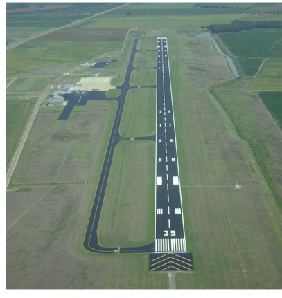
| Runway: 17 | Runway: 35 | ||
| Mag heading: | 167° | Mag heading: | 347° |
| Rwy Slope: | .00% | Rwy Slope: | .00% |
| Approach: | Approach: | ILS/DME | |
| Pattern: | Left Traffic | Pattern: | Right Traffic |
| Markings: | PRECISION INSTRUMENT | Markings: | PRECISION INSTRUMENT |
| Marking Condition: | GOOD | Marking Condition: | GOOD |
| Arresting Dev: | Arresting Dev: | ||
| Lat & Long: | N3441.8 W09021.1 | Lat. & Long.: | N3440.4 W09020.7 |
| Elev: | 194.4 ft. MSL | Elev: | 194.4 ft. MSL |
| TCH: | 50 ft. AGL | TCH: | 47 ft. AGL |
| Visual Glide Path: | 3.00 degrees | Visual Glide Path: | 3.00 degrees |
| Displaced Threshold: | No | Displaced Threshold: | No |
| Touchdown Zone: | YES | Touchdown Zone: | YES |
| Touchdown Elev.: | 194.4 feet | Touchdown Elev.: | 194.4 feet |
| Visual Glide Slope: | 4-Light PAPI on LEFT side of Runway | Visual Glide Slope: | 4-Light PAPI on LEFT side of Runway |
| RVR Equipment: | RVR Equipment: | ||
| RVV Equipment: | NO | RVV Equipment: | NO |
| Approach Lights: | Approach Lights: | MALSR - 1,400 foot medium intensity approach lighting system with runway alignment indicator lights | |
| REIL: | YES | REIL: | NO |
| Centerline Lights: | NO | Centerline Lights: | NO |
| Touchdown lights: | NO | Touchdown lights: | NO |
| Runway Category: | Runway with a Non-precision Approach having visibility minimums greater than 3/4 mile | Runway Category: | Precision Instrument Runway |
| Declared Distances: | Declared Distances: |
Thanks for using FltPlan.com
all rights reserved © 1999-2026 by Flight Plan LLC