
| FULTON COUNTY WAUSEON OH |
| |
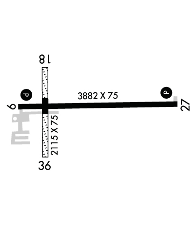
| Lat: N 4136.6 Long: W 08407.6 Elev: 781 Var: +05 Longest Runway: 3882 | ||
| AWOS: 127.37 CTAF: 123.0 | ||
| ||||||
| ||||||
|
| Rwy | Rwy | |||||||
| 3882x75 | 3882' | 3882x75 | 3882' | |||||
| 2115x75 | 2115' | 2115x75 | 2115' | |||||
| Runway ID | Single Wheel | Double Wheel | Double Tandem Wheel | Dual Double Wheel |
| 09/27 | 30,000 | N/A | N/A | N/A |
| 18/36 | N/A | N/A | N/A | N/A |
| These numbers are Advisory and are not limits. The Airport Manager should have more accurate Weight Limits | ||||
 Airport Diagram might not be current. | |
| Facility Name: | FULTON COUNTY |
| City Name: | WAUSEON |
| County: | FULTON |
| State abbrev: | OH |
| State Name: | OHIO |
| Ownership: | PUBLICLY OWNED |
| Use: | OPEN TO THE PUBLIC |
| Owner's Name: | FULTON COUNTY |
| Address: | 152 S FULTON ST STE 270 |
| WAUSEON, OH 43567-3308 | |
| Owner's Phone: | 419-337-9255 |
| Manager's Name: | MASON MARCONI |
| Address: | 9460 COUNTY ROAD 14 |
| WAUSEON, OH 43567-9670 | |
| Phone: | 419-335-3993 |
| FAA Region: | GREAT LAKES |
| FAA Field Office: | DET |
| Date | Sunrise | Sunset |
|---|---|---|
| 06/08/26 Monday | 6:02 | 21:09 |
| 06/09/26 Tuesday | 6:02 | 21:09 |
| 06/10/26 Wednesday | 6:02 | 21:10 |
| 06/11/26 Thursday | 6:02 | 21:11 |
| 06/12/26 Friday | 6:02 | 21:11 |
| 06/13/26 Saturday | 6:02 | 21:12 |
| 06/14/26 Sunday | 6:02 | 21:12 |
| 06/15/26 Monday | 6:02 | 21:12 |
| 06/16/26 Tuesday | 6:02 | 21:13 |
| 06/17/26 Wednesday | 6:02 | 21:13 |
| 06/18/26 Thursday | 6:02 | 21:13 |
| 06/19/26 Friday | 6:02 | 21:14 |
| 06/20/26 Saturday | 6:02 | 21:14 |
| 06/21/26 Sunday | 6:02 | 21:14 |
| Airport Attendance Schedule | MON-FRI 0900-1700; FOR SVC AFT HRS CALL AMGR. |
| Airport Status | OPERATIONAL (This Status can change at any time - please check NOTAMS) |
| Airport Lighting Schedule | ACTVT REIL RWY 09 & 27; PAPI RWY 09 & 27; MIRL RWY 09/27 - CTAF. |
| Airport Storage Available | Tie Downs, Hanger |
| Extra Services Available | Air Ambulance, Flight Instruction |
| Wind Indicator | YES - (unlit) |
| Control Tower | NO |
| CTAF Frequency | 123.000 |
| Unicom Frequency | 123.000 |
| Rotating Beacon Color | WG |
| Segmented Circle | NO |
| Landing Fee | NO |
| Airport Inspected | STATE - performed by STATE AERONAUTICAL PERSONNEL |
| Inspection Date | 10/03/2025 |
| Type of Fuel Available | Grade 100LL, JET AUL94; -10100LL & UL94 AVBL H24 SELF SVC VIA CREDIT CARD. |
| Airframe Repair Service | NONE |
| Power Plant Repair Service | NONE |
| Latitude | N4136.6 |
| Longitude | W08407.6 (ESTIMATED) |
| Arpt Elevation | 780ft (SURVEYED) |
| Magnetic Variation | 05W |
| 4 miles N | of WAUSEON |
| Traffic Pattern Altitude | |
| Sectional Chart | DETROIT |
| Operations (Reported) | Yearly | Avg. Daily |
|---|---|---|
| General Aviation Transient | 0 | 0 |
| General Aviation Local | 0 | 0 |
| Air Taxi | 0 | 0 |
| Commerical | 0 | 0 |
| Commuter | 0 | 0 |
| Military | 0 | 0 |
| Aircraft based on Field | |
|---|---|
| General Aviation Singles | 0 |
| General Aviation Multi | 0 |
| Jet Aircraft | 0 |
| General Aviation Helicopters | 0 |
| Military Aircraft | 0 |
| Gliders | 0 |
| Ultralights | 0 |
| FSS on field | NO |
| FSS tie-in | CLEVELAND |
| FSS Phone | 1-800-WX-BRIEF |
| Who issues Notams | USE |
| Notam D service at airport | YES |
| ARTCC Name | CLEVELAND |
| Airport Certification | |
| Aircraft Rescue & Firefighting Index | None |
| Airport of Entry | No |
| Custom Landing Rights | No |
| Joint Civil/Military | No |
| Military Landing rights | No |
| NATIONAL PLAN OF INTEGRATED AIRPORT SYSTEMS (NPIAS) |
| DEER & BIRDS ON & INVOF ARPT. |
| RESTROOM ACCESS, UNICOM. |
| FOR CD CTC TOLEDO APCH AT 419-865-1495. |
| RWY 27 CLIMB STRAIGHT OUT TO 1300 MSL. |
| RWY 18/3 6 359 FT OF CNTR SECTION ASPH, NORTH 270 FT TURF, SOUTH 1328 FT TURF. |
Airport Communications & Frequencies:
| ||||||||||||||
| Runway: 09 | Runway: 27 | ||
| Mag heading: | 94° | Mag heading: | 274° |
| Rwy Slope: | -.23% Down | Rwy Slope: | .23% Up |
| Approach: | Approach: | ||
| Pattern: | Left Traffic | Pattern: | Left Traffic |
| Markings: | NONPRECISION INSTRUMENT | Markings: | NONPRECISION INSTRUMENT |
| Marking Condition: | GOOD | Marking Condition: | GOOD |
| Arresting Dev: | Arresting Dev: | ||
| Lat & Long: | N4136.6 W08408.0 | Lat. & Long.: | N4136.6 W08407.1 |
| Elev: | 778.8 ft. MSL | Elev: | 770.0 ft. MSL |
| TCH: | 24 ft. AGL | TCH: | 33 ft. AGL |
| Visual Glide Path: | 3.00 degrees | Visual Glide Path: | 3.00 degrees |
| Displaced Threshold: | No | Displaced Threshold: | No |
| Touchdown Zone: | YES | Touchdown Zone: | YES |
| Touchdown Elev.: | 779.1 feet | Touchdown Elev.: | 777.1 feet |
| Visual Glide Slope: | 4-Light PAPI on LEFT side of Runway | Visual Glide Slope: | 4-Light PAPI on RIGHT side of Runway |
| RVR Equipment: | RVR Equipment: | ||
| RVV Equipment: | NO | RVV Equipment: | NO |
| Approach Lights: | Approach Lights: | ||
| REIL: | YES | REIL: | YES |
| Centerline Lights: | NO | Centerline Lights: | NO |
| Touchdown lights: | NO | Touchdown lights: | NO |
| Runway Category: | Runway with a Non-precision Approach | Runway Category: | Runway with a Non-precision Approach |
| Declared Distances: | Declared Distances: | ||
| Obstructions: | ROAD | Obstructions: | |
| Marked: | NOT Marked/Lighted | Marked: | |
| Clearance slope: | 17:1 | Clearance slope: | 20:1 |
| Obstruction height: | 15 feet AGL | Obstruction height: | |
| Dist. from runway: | 457 feet | Dist. from runway: | |
| Centerline offset: | Centerline offset: | ||
| Comments: | Comments: |
| Runway: 18 | Runway: 36 | ||
| Mag heading: | 185° | Mag heading: | 5° |
| Rwy Slope: | .17% Up | Rwy Slope: | -.17% Down |
| Approach: | Approach: | ||
| Pattern: | Left Traffic | Pattern: | Left Traffic |
| Markings: | Markings: | ||
| Marking Condition: | GOOD; TURF PTN MKD WITH WHITE CONES. | Marking Condition: | GOOD; TURF PTN MKD WITH WHITE CONES. |
| Arresting Dev: | Arresting Dev: | ||
| Lat & Long: | N4136.7 W08407.8 | Lat. & Long.: | N4136.4 W08407.8 |
| Elev: | 777.0 ft. MSL | Elev: | 780.6 ft. MSL |
| TCH: | TCH: | ||
| Visual Glide Path: | Visual Glide Path: | ||
| Displaced Threshold: | No | Displaced Threshold: | No |
| Touchdown Zone: | YES | Touchdown Zone: | YES |
| Touchdown Elev.: | 780.8 feet | Touchdown Elev.: | 780.8 feet |
| Visual Glide Slope: | Visual Glide Slope: | ||
| RVR Equipment: | RVR Equipment: | ||
| RVV Equipment: | NO | RVV Equipment: | NO |
| Approach Lights: | Approach Lights: | ||
| REIL: | NO | REIL: | NO |
| Centerline Lights: | NO | Centerline Lights: | NO |
| Touchdown lights: | NO | Touchdown lights: | NO |
| Runway Category: | Runway with a Visual Approach | Runway Category: | Runway with a Visual Approach |
| Declared Distances: | Declared Distances: | ||
| Obstructions: | Obstructions: | TREE | |
| Marked: | Marked: | NOT Marked/Lighted | |
| Clearance slope: | 20:1 | Clearance slope: | 17:1 |
| Obstruction height: | Obstruction height: | 66 feet AGL | |
| Dist. from runway: | Dist. from runway: | 1161 feet | |
| Centerline offset: | Centerline offset: | 229 feet right of centerline | |
| Comments: | Comments: |
Thanks for using FltPlan.com
all rights reserved © 1999-2026 by Flight Plan LLC
