
| INDIANAPOLIS METROPOLITAN INDIANAPOLIS IN |
| |
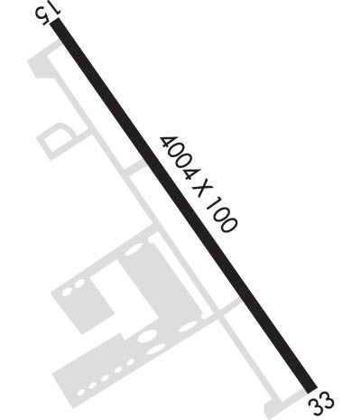
| Lat: N 3956.1 Long: W 08602.7 Elev: 811 Var: +03 Longest Runway: 4004 | ||
| Clr Del: 121.625 AWOS: 119.37 CTAF: 123.0 | ||
| |||||||||||||||||||||||||||||||||||||||||||||||||||||||||||||||||||||
| |||||||||||||||||||||||||||||||||||||||||||||||||||||||||||||||||||||
| |||||||||||||||||||||||||||||||||||||||||||||||||||||||||||||||||||||
| Rwy | Rwy | |||||||
| 4004x100 | 3848' | 4004x100 | 4004' | |||||
| Runway ID | Single Wheel | Double Wheel | Double Tandem Wheel | Dual Double Wheel |
| 15/33 | 17,000 | N/A | N/A | N/A |
| These numbers are Advisory and are not limits. The Airport Manager should have more accurate Weight Limits | ||||
 Airport Diagram might not be current. | |
| Facility Name: | INDIANAPOLIS METRO |
| City Name: | INDIANAPOLIS |
| County: | HAMILTON |
| State abbrev: | IN |
| State Name: | INDIANA |
| Ownership: | PUBLICLY OWNED |
| Use: | OPEN TO THE PUBLIC |
| Owner's Name: | INDIANAPOLIS ARPT AUTH |
| Address: | 7800 COL. H. WEIR COOK MEM. DRIVE, SUITE 100 |
| INDIANAPOLIS, IN 46241-4941 | |
| Owner's Phone: | (317) 487-7243 |
| Manager's Name: | KEITH BERLEN |
| Address: | 7800 COL H. WEIR COOK MEM. DRIVE, SUITE 100 |
| INDIANAPOLIS, IN 46241-4941 | |
| Phone: | (317) 487-7243 |
| FAA Region: | GREAT LAKES |
| FAA Field Office: | CHI |
| Date | Sunrise | Sunset |
|---|---|---|
| 09/24/21 Friday | 7:33 | 19:38 |
| 09/25/21 Saturday | 7:34 | 19:37 |
| 09/26/21 Sunday | 7:35 | 19:35 |
| 09/27/21 Monday | 7:36 | 19:33 |
| 09/28/21 Tuesday | 7:37 | 19:32 |
| 09/29/21 Wednesday | 7:38 | 19:30 |
| 09/30/21 Thursday | 7:39 | 19:29 |
| 10/01/21 Friday | 7:40 | 19:27 |
| 10/02/21 Saturday | 7:41 | 19:25 |
| 10/03/21 Sunday | 7:42 | 19:24 |
| 10/04/21 Monday | 7:43 | 19:22 |
| 10/05/21 Tuesday | 7:44 | 19:20 |
| 10/06/21 Wednesday | 7:45 | 19:19 |
| 10/07/21 Thursday | 7:46 | 19:17 |
| Airport Attendance Schedule | 7 Days A Week 0800-1900 |
| Airport Status | OPERATIONAL (This Status can change at any time - please check NOTAMS) |
| Airport Lighting Schedule | ACTVT REIL RWY 15 AND 33, MIRL RWY 15/33 - CTAF. |
| Airport Storage Available | Tie Downs, Hanger |
| Extra Services Available | Air Ambulance, Charter, Flight Instruction, Aircraft Rental, Aircraft Sales |
| Wind Indicator | YES - (lighted) |
| Control Tower | NO |
| CTAF Frequency | 123.000 |
| Unicom Frequency | 123.000 |
| Rotating Beacon Color | CLEAR-GREEN (Light Land Airport) |
| Segmented Circle | Y-L |
| Landing Fee | NO |
| Airport Inspected | STATE - performed by STATE AERONAUTICAL PERSONNEL |
| Inspection Date | 08/25/2020 |
| Type of Fuel Available | Grade 100LL, JET A (freeze point -40C) |
| Airframe Repair Service | MAJOR |
| Power Plant Repair Service | MAJOR |
| Latitude | N3956.1 |
| Longitude | W08602.7 (ESTIMATED) |
| Arpt Elevation | 811ft (SURVEYED) |
| Magnetic Variation | 03W |
| 8 miles NE | of INDIANAPOLIS |
| Traffic Pattern Altitude | |
| Sectional Chart | ST LOUIS |
| Operations (Reported) | Yearly | Avg. Daily |
|---|---|---|
| General Aviation Transient | 7081 | 19 |
| General Aviation Local | 11192 | 31 |
| Air Taxi | 3883 | 11 |
| Commerical | 0 | 0 |
| Commuter | 0 | 0 |
| Military | 686 | 2 |
| Aircraft based on Field | |
|---|---|
| General Aviation Singles | 83 |
| General Aviation Multi | 7 |
| Jet Aircraft | 4 |
| General Aviation Helicopters | 5 |
| Military Aircraft | 0 |
| Gliders | 0 |
| Ultralights | 1 |
| FSS on field | NO |
| FSS tie-in | TERRE HAUTE |
| FSS Phone | 1-800-WX-BRIEF |
| Who issues Notams | HUF |
| Notam D service at airport | YES |
| ARTCC Name | INDIANAPOLIS |
| Airport Certification | |
| Aircraft Rescue & Firefighting Index | None |
| Airport of Entry | No |
| Custom Landing Rights | No |
| Joint Civil/Military | No |
| Military Landing rights | YES |
| NATIONAL PLAN OF INTEGRATED AIRPORT SYSTEMS (NPIAS) |
| GRANT AGREEMENTS UNDER FAAP/ADAP/AIP |
| ASSURANCES PURSUANT TO TITLE VI, CIVIL RIGHTS ACT OF 1964 |
| OUTSIDE PHONE AVBL. |
| ACFT TAKEOFF/LANDING FM RY 15 DURING CALM WIND/CROSSWIND CONDITIONS; DURING ANY QUESTIONABLE PERIOD RY 15 SHALL BE PREFERRED RY - CALL AMGR 317-487-9594. |
| FBO PHONE NUMBER - 317-849-0840 |
| 500 FT AGL MOORED HOT AIR BALLOON LCTD APRXLY 4.4 MILES NORTH-NORTHWEST OF ARPT. BALLOON WILL OPER DLY FROM 1300-2200Z++ AND IS INTERNALLY ILLUMINATED. |
Airport Communications & Frequencies:
| ||||||||||||||||
| Runway: 15 | Runway: 33 | ||
| Mag heading: | 149° | Mag heading: | 329° |
| Rwy Slope: | .60% Up | Rwy Slope: | -.60% Down |
| Approach: | Approach: | ||
| Pattern: | Left Traffic | Pattern: | Left Traffic |
| Markings: | NONPRECISION INSTRUMENT | Markings: | NONPRECISION INSTRUMENT |
| Marking Condition: | GOOD | Marking Condition: | GOOD |
| Arresting Dev: | Arresting Dev: | ||
| Lat & Long: | N3956.4 W08602.9 | Lat. & Long.: | N3955.9 W08602.5 |
| Elev: | 787.1 ft. MSL | Elev: | 811.2 ft. MSL |
| TCH: | 43 ft. AGL | TCH: | 27 ft. AGL |
| Visual Glide Path: | 3.00 degrees | Visual Glide Path: | 3.50 degrees |
| Displaced Threshold: | 156 feet | Displaced Threshold: | No |
| Touchdown Zone: | YES | Touchdown Zone: | YES |
| Touchdown Elev.: | 805.0 feet | Touchdown Elev.: | 811.3 feet |
| Visual Glide Slope: | 4-Light PAPI on LEFT side of Runway | Visual Glide Slope: | 4-Light PAPI on LEFT side of Runway |
| RVR Equipment: | RVR Equipment: | ||
| RVV Equipment: | NO | RVV Equipment: | NO |
| Approach Lights: | Approach Lights: | ||
| REIL: | YES | REIL: | YES |
| Centerline Lights: | NO | Centerline Lights: | NO |
| Touchdown lights: | NO | Touchdown lights: | NO |
| Runway Category: | Runway with a Non-precision Approach having visibility minimums greater than 3/4 mile | Runway Category: | Runway with a Non-precision Approach having visibility minimums greater than 3/4 mile |
| Declared Distances: | Declared Distances: | ||
| Obstructions: | ROAD | Obstructions: | TREE |
| Marked: | NOT Marked/Lighted | Marked: | NOT Marked/Lighted |
| Clearance slope: | 6:1; APCH SLOPE 21:1 AT DSPLCD THR; 37 FT TREES 800 FT FM DSPLCD THR 260 FT LEFT. | Clearance slope: | 25:1 |
| Obstruction height: | 11 feet AGL | Obstruction height: | 45 feet AGL |
| Dist. from runway: | 275 feet | Dist. from runway: | 1345 feet |
| Centerline offset: | 260 right of centerline | Centerline offset: | 170 feet right of centerline |
| Comments: | Comments: |
Thanks for using FltPlan.com
all rights reserved © 1999-2021 by Flight Plan LLC