
| COFFEY COUNTY BURLINGTON KS |
| |
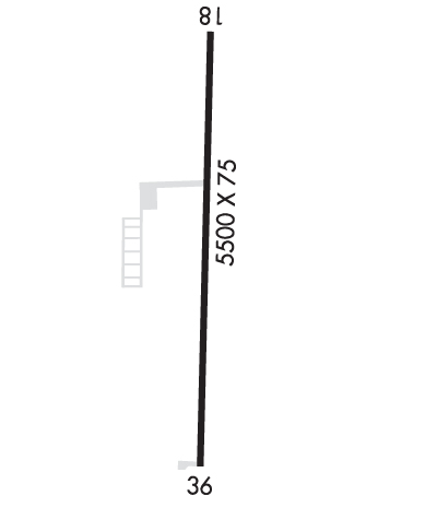
| Lat: N 3818.1 Long: W 09543.5 Elev: 1174 Var: -05 Longest Runway: 5500 | ||
| AWOS: 121.12 CTAF: 123.0 | ||
| |||||||||||||||||||||||
| |||||||||||||||||||||||
| |||||||||||||||||||||||
| Rwy | Rwy | |||||||
| 5500x75 | 5500' | 5500x75 | 5500' | |||||
| Runway ID | Single Wheel | Double Wheel | Double Tandem Wheel | Dual Double Wheel |
| 18/36 | 39,000 | 50,000 | N/A | N/A |
| These numbers are Advisory and are not limits. The Airport Manager should have more accurate Weight Limits | ||||
 Airport Diagram might not be current. | |
| Facility Name: | COFFEY COUNTY |
| City Name: | BURLINGTON |
| County: | COFFEY |
| State abbrev: | KS |
| State Name: | KANSAS |
| Ownership: | PUBLICLY OWNED |
| Use: | OPEN TO THE PUBLIC |
| Owner's Name: | COUNTY OF COFFEY |
| Address: | 1899 HWY 75 |
| BURLINGTON, KS 66839 | |
| Owner's Phone: | 620-364-5346 |
| Manager's Name: | DARREN ISCH |
| Address: | 1899 HWY 75 |
| BURLINGTON, KS 66839 | |
| Phone: | 620-364-5346 |
| FAA Region: | CENTRAL |
| FAA Field Office: | NONE |
| Date | Sunrise | Sunset |
|---|---|---|
| 06/08/26 Monday | 5:59 | 20:45 |
| 06/09/26 Tuesday | 5:59 | 20:45 |
| 06/10/26 Wednesday | 5:59 | 20:46 |
| 06/11/26 Thursday | 5:59 | 20:46 |
| 06/12/26 Friday | 5:59 | 20:47 |
| 06/13/26 Saturday | 5:59 | 20:47 |
| 06/14/26 Sunday | 5:59 | 20:48 |
| 06/15/26 Monday | 5:59 | 20:48 |
| 06/16/26 Tuesday | 5:59 | 20:48 |
| 06/17/26 Wednesday | 5:59 | 20:49 |
| 06/18/26 Thursday | 5:59 | 20:49 |
| 06/19/26 Friday | 5:59 | 20:49 |
| 06/20/26 Saturday | 5:59 | 20:50 |
| 06/21/26 Sunday | 6:00 | 20:50 |
| Airport Attendance Schedule | MON-FRI 0800-1800, SAT-SUN 0800-1700; ARPT UNATNDD THANKSGIVING & CHRISTMAS. |
| Airport Status | OPERATIONAL (This Status can change at any time - please check NOTAMS) |
| Airport Lighting Schedule | MIRL RWY 18/36 OPRS DUSK-2200. AFT 2200 ACTVT PAPI RWY 18 & 36; MIRL RWY 18/36 - CTAF. |
| Airport Storage Available | Tie Downs, Hanger |
| Extra Services Available | Crop Dusting, Flight Instruction, Aircraft Rental, Aircraft Sales |
| Wind Indicator | YES - (unlit) |
| Control Tower | NO |
| CTAF Frequency | 123.000 |
| Unicom Frequency | 123.000 |
| Rotating Beacon Color | WG |
| Segmented Circle | YES |
| Landing Fee |
| Airport Inspected | STATE - performed by PRIVATE CONTRACT PERSONNEL |
| Inspection Date | 09/27/2025 |
| Type of Fuel Available | Grade 100LL, JET A (freeze point -40C) |
| Airframe Repair Service | MAJOR |
| Power Plant Repair Service | MAJOR |
| Latitude | N3818.1 |
| Longitude | W09543.5 (ESTIMATED) |
| Arpt Elevation | 1174ft (SURVEYED) |
| Magnetic Variation | 05E |
| 7 miles N | of BURLINGTON |
| Traffic Pattern Altitude | |
| Sectional Chart | KANSAS CITY |
| Operations (Reported) | Yearly | Avg. Daily |
|---|---|---|
| General Aviation Transient | 0 | 0 |
| General Aviation Local | 0 | 0 |
| Air Taxi | 0 | 0 |
| Commerical | 0 | 0 |
| Commuter | 0 | 0 |
| Military | 0 | 0 |
| Aircraft based on Field | |
|---|---|
| General Aviation Singles | 0 |
| General Aviation Multi | 0 |
| Jet Aircraft | 0 |
| General Aviation Helicopters | 0 |
| Military Aircraft | 0 |
| Gliders | 0 |
| Ultralights | 0 |
| FSS on field | NO |
| FSS tie-in | WICHITA |
| FSS Phone | 1-800-WX-BRIEF |
| Who issues Notams | ICT |
| Notam D service at airport | YES |
| ARTCC Name | KANSAS CITY |
| Airport Certification | |
| Aircraft Rescue & Firefighting Index | None |
| Airport of Entry | No |
| Custom Landing Rights | No |
| Joint Civil/Military | No |
| Military Landing rights | No |
| NATIONAL PLAN OF INTEGRATED AIRPORT SYSTEMS (NPIAS) |
| ULTRALIGHT ACTVTY ON & INVOF ARPT. |
| WILDLIFE ON AND INVOF ARPT. |
| FOR CD CTC KANSAS CITY ARTCC AT 913-254-8508. |
Airport Communications & Frequencies:
| |||||||||
| Runway: 18 | Runway: 36 | ||
| Mag heading: | 175° | Mag heading: | 355° |
| Rwy Slope: | -.03% Down | Rwy Slope: | .03% Up |
| Approach: | Approach: | ||
| Pattern: | Left Traffic | Pattern: | Left Traffic |
| Markings: | NONPRECISION INSTRUMENT | Markings: | NONPRECISION INSTRUMENT |
| Marking Condition: | GOOD | Marking Condition: | GOOD |
| Arresting Dev: | Arresting Dev: | ||
| Lat & Long: | N3818.6 W09543.5 | Lat. & Long.: | N3817.7 W09543.5 |
| Elev: | 1171.8 ft. MSL | Elev: | 1169.9 ft. MSL |
| TCH: | 40 ft. AGL | TCH: | 43 ft. AGL |
| Visual Glide Path: | 3.00 degrees | Visual Glide Path: | 3.00 degrees |
| Displaced Threshold: | No | Displaced Threshold: | No |
| Touchdown Zone: | YES | Touchdown Zone: | YES |
| Touchdown Elev.: | 1174.4 feet | Touchdown Elev.: | 1174.3 feet |
| Visual Glide Slope: | 4-Light PAPI on LEFT side of Runway | Visual Glide Slope: | 4-Light PAPI on LEFT side of Runway |
| RVR Equipment: | RVR Equipment: | ||
| RVV Equipment: | NO | RVV Equipment: | NO |
| Approach Lights: | Approach Lights: | ||
| REIL: | YES | REIL: | YES |
| Centerline Lights: | NO | Centerline Lights: | NO |
| Touchdown lights: | NO | Touchdown lights: | NO |
| Runway Category: | Runway with a Non-precision Approach having visibility minimums greater than 3/4 mile | Runway Category: | Runway with a Non-precision Approach having visibility minimums greater than 3/4 mile |
| Declared Distances: | Declared Distances: |
Thanks for using FltPlan.com
all rights reserved © 1999-2026 by Flight Plan LLC
