
| WAUKEGAN RGNL CHICAGO/WAUKEGAN IL |
| |
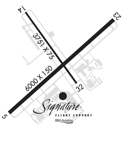
| Lat: N 4225.3 Long: W 08752.1 Elev: 728 Var: +03 Longest Runway: 6001 | ||
| Dept. ATIS: 132.4 Arr. ATIS: 132.4 Ground: 121.65 Tower: 120.05 | ||

| ||||||||||||||||||||||||||||||||||||||||||||
| ||||||||||||||||||||||||||||||||||||||||||||
| ||||||||||||||||||||||||||||||||||||||||||||
| Rwy | Rwy | |||||||
| 6001x150 | 6001' | 6001x150 | 6001' | 110.70 - 231° | ||||
| 3750x75 | 3261' | 3750x75 | 3750' | |||||
| Runway ID | Single Wheel | Double Wheel | Double Tandem Wheel | Dual Double Wheel |
| 05/23 | 95,000 | 120,000 | 200,000 | N/A |
| 14/32 | 16,000 | 23,000 | N/A | N/A |
| These numbers are Advisory and are not limits. The Airport Manager should have more accurate Weight Limits | ||||
 Airport Diagram might not be current. | |
| Facility Name: | WAUKEGAN NTL |
| City Name: | CHICAGO/WAUKEGAN |
| County: | LAKE |
| State abbrev: | IL |
| State Name: | ILLINOIS |
| Ownership: | PUBLICLY OWNED |
| Use: | OPEN TO THE PUBLIC |
| Owner's Name: | WAUKEGAN PORT DISTRICT |
| Address: | PO BOX 620 |
| WAUKEGAN, IL 60079 | |
| Owner's Phone: | 847-244-0055 |
| Manager's Name: | SKIP GOSS |
| Address: | 2601 PLANE REST DRIVE; EMAIL ADDRESS: SGOSS@WAUKEGANPORT.COM |
| WAUKEGAN, IL 60087 | |
| Phone: | 847-244-0055 |
| FAA Region: | GREAT LAKES |
| FAA Field Office: | CHI |
| Date | Sunrise | Sunset |
|---|---|---|
| 09/24/21 Friday | 6:41 | 18:46 |
| 09/25/21 Saturday | 6:42 | 18:44 |
| 09/26/21 Sunday | 6:43 | 18:42 |
| 09/27/21 Monday | 6:44 | 18:40 |
| 09/28/21 Tuesday | 6:45 | 18:39 |
| 09/29/21 Wednesday | 6:46 | 18:37 |
| 09/30/21 Thursday | 6:47 | 18:35 |
| 10/01/21 Friday | 6:48 | 18:33 |
| 10/02/21 Saturday | 6:49 | 18:32 |
| 10/03/21 Sunday | 6:50 | 18:30 |
| 10/04/21 Monday | 6:52 | 18:28 |
| 10/05/21 Tuesday | 6:53 | 18:26 |
| 10/06/21 Wednesday | 6:54 | 18:25 |
| 10/07/21 Thursday | 6:55 | 18:23 |
| Airport Attendance Schedule | CONTINUOUS |
| Airport Status | OPERATIONAL (This Status can change at any time - please check NOTAMS) |
| Airport Lighting Schedule | ACTVT MALSR RWY 23; REIL RWY 05; HIRL RWY 05/23; TWY LGTS - CTAF. WHEN ATCT CLSD, MIRL RWY 14/32 PRESET TO LOW INTST, TO INCR INTST & ACTVT - CTAF. |
| Airport Storage Available | Tie Downs, Hanger |
| Extra Services Available | Air Freight, Avionics, Cargo Handling, Charter, Flight Instruction, Aircraft Rental |
| Wind Indicator | YES - (lighted) |
| Control Tower | YES |
| CTAF Frequency | 120.050 |
| Unicom Frequency | |
| Rotating Beacon Color | CLEAR-GREEN (Light Land Airport) |
| Segmented Circle | YES |
| Landing Fee |
| Airport Inspected | STATE - performed by STATE AERONAUTICAL PERSONNEL |
| Inspection Date | 06/02/2020 |
| Type of Fuel Available | Grade 100LL, JET A (freeze point -40C); -10FUEL IS PRVDD BY A DOD CONTRACT. 100 LL AVBL 24HR WITH CREDIT CARD FM SELF SERVE PUMP ON TSNT RAMP. |
| Airframe Repair Service | MAJOR |
| Power Plant Repair Service | MAJOR |
| Latitude | N4225.3 |
| Longitude | W08752.1 (ESTIMATED) |
| Arpt Elevation | 728ft (SURVEYED) |
| Magnetic Variation | 03W |
| 35 miles N | of CHICAGO/WAUKEGAN |
| Traffic Pattern Altitude | |
| Sectional Chart | CHICAGO |
| Operations (Reported) | Yearly | Avg. Daily |
|---|---|---|
| General Aviation Transient | 21130 | 58 |
| General Aviation Local | 19231 | 53 |
| Air Taxi | 3792 | 10 |
| Commerical | 1 | 0 |
| Commuter | 0 | 0 |
| Military | 861 | 2 |
| Aircraft based on Field | |
|---|---|
| General Aviation Singles | 78 |
| General Aviation Multi | 12 |
| Jet Aircraft | 29 |
| General Aviation Helicopters | 1 |
| Military Aircraft | 0 |
| Gliders | 0 |
| Ultralights | 0 |
| FSS on field | NO |
| FSS tie-in | KANKAKEE |
| FSS Phone | 1-800-WX-BRIEF |
| Who issues Notams | UGN |
| Notam D service at airport | YES |
| ARTCC Name | CHICAGO |
| Airport Certification | |
| Aircraft Rescue & Firefighting Index | None |
| Airport of Entry | No |
| Custom Landing Rights | YES; US CUSTOMS USER FEE ARPT. FOR CUSTOMS CLNC 2 HRS MIN ADVN NOTICE RQRD MON-FRI 11:00 - 19:00 LCL & BY 4PM FRI FOR WKEND ARRS. CTC CBP (224)529-1468. |
| Joint Civil/Military | No |
| Military Landing rights | YES |
| NATIONAL PLAN OF INTEGRATED AIRPORT SYSTEMS (NPIAS) |
| GRANT AGREEMENTS UNDER FAAP/ADAP/AIP |
| ASSURANCES PURSUANT TO TITLE VI, CIVIL RIGHTS ACT OF 1964 |
| BIRDS ON & INVOF ARPT. |
| FOR CD WHEN ATCT IS CLSD CTC CHICAGO APCH AT 847-289-0926. |
Airport Communications & Frequencies:
| |||||||||||||||||||||
| Runway: 05 | Runway: 23 | ||
| Mag heading: | 51° | Mag heading: | 231° |
| Rwy Slope: | -.04% Down | Rwy Slope: | .04% Up |
| Approach: | Approach: | ILS | |
| Pattern: | Left Traffic | Pattern: | Right Traffic |
| Markings: | PRECISION INSTRUMENT | Markings: | PRECISION INSTRUMENT |
| Marking Condition: | GOOD | Marking Condition: | GOOD |
| Arresting Dev: | Arresting Dev: | ||
| Lat & Long: | N4225.0 W08752.5 | Lat. & Long.: | N4225.6 W08751.5 |
| Elev: | 725.8 ft. MSL | Elev: | 723.4 ft. MSL |
| TCH: | 35 ft. AGL | TCH: | 52 ft. AGL |
| Visual Glide Path: | 3.00 degrees | Visual Glide Path: | 3.00 degrees |
| Displaced Threshold: | No | Displaced Threshold: | No |
| Touchdown Zone: | YES | Touchdown Zone: | YES |
| Touchdown Elev.: | 725.8 feet | Touchdown Elev.: | 723.5 feet |
| Visual Glide Slope: | 4-BOX VASI ON LEFT SIDE OF RUNWAY | Visual Glide Slope: | 4-BOX VASI ON LEFT SIDE OF RUNWAY |
| RVR Equipment: | RVR Equipment: | ||
| RVV Equipment: | NO | RVV Equipment: | NO |
| Approach Lights: | Approach Lights: | MALSR - 1,400 foot medium intensity approach lighting system with runway alignment indicator lights | |
| REIL: | YES | REIL: | NO |
| Centerline Lights: | NO | Centerline Lights: | NO |
| Touchdown lights: | NO | Touchdown lights: | NO |
| Runway Category: | Runway with a Non-precision Approach having visibility minimums greater than 3/4 mile | Runway Category: | Precision Instrument Runway |
| Declared Distances: | Declared Distances: | ||
| Obstructions: | ROAD | Obstructions: | TREE |
| Marked: | NOT Marked/Lighted | Marked: | NOT Marked/Lighted |
| Clearance slope: | 6:1 | Clearance slope: | 27:1 |
| Obstruction height: | 12 feet AGL | Obstruction height: | 34 feet AGL |
| Dist. from runway: | 281 feet | Dist. from runway: | 1090 feet |
| Centerline offset: | 502 left of centerline | Centerline offset: | 419 feet right of centerline |
| Comments: | Comments: |
| Runway: 14 | Runway: 32 | ||
| Mag heading: | 147° | Mag heading: | 327° |
| Rwy Slope: | -.42% Down | Rwy Slope: | .42% Up |
| Approach: | Approach: | ||
| Pattern: | Left Traffic | Pattern: | Left Traffic |
| Markings: | BASIC | Markings: | BASIC |
| Marking Condition: | GOOD | Marking Condition: | GOOD |
| Arresting Dev: | Arresting Dev: | ||
| Lat & Long: | N4225.7 W08752.4 | Lat. & Long.: | N4225.2 W08751.9 |
| Elev: | 727.9 ft. MSL | Elev: | 712.0 ft. MSL |
| TCH: | 30 ft. AGL | TCH: | |
| Visual Glide Path: | 3.50 degrees | Visual Glide Path: | |
| Displaced Threshold: | 489 feet | Displaced Threshold: | No |
| Touchdown Zone: | YES | Touchdown Zone: | YES |
| Touchdown Elev.: | 728.1 feet | Touchdown Elev.: | 727.3 feet |
| Visual Glide Slope: | 4-BOX VASI ON LEFT SIDE OF RUNWAY | Visual Glide Slope: | |
| RVR Equipment: | RVR Equipment: | ||
| RVV Equipment: | NO | RVV Equipment: | NO |
| Approach Lights: | Approach Lights: | ||
| REIL: | NO | REIL: | NO |
| Centerline Lights: | NO | Centerline Lights: | NO |
| Touchdown lights: | NO | Touchdown lights: | NO |
| Runway Category: | Runway with a Visual Approach | Runway Category: | Runway with a Visual Approach |
| Declared Distances: | Declared Distances: | ||
| Obstructions: | ROAD | Obstructions: | |
| Marked: | NOT Marked/Lighted | Marked: | |
| Clearance slope: | 1:1; APCH RATIO IS 26:1 AT DSPLCD THLD. | Clearance slope: | 20:1 |
| Obstruction height: | 29 feet AGL | Obstruction height: | |
| Dist. from runway: | 205 feet | Dist. from runway: | |
| Centerline offset: | 125 left of centerline | Centerline offset: | |
| Comments: | Comments: |
Thanks for using FltPlan.com
all rights reserved © 1999-2021 by Flight Plan LLC
