
| BERMUDA DUNES PALM SPRINGS CA |
| |
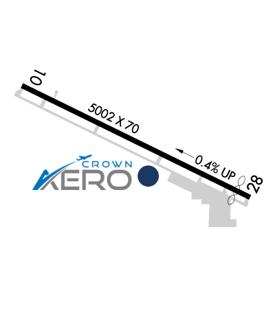
| Lat: N 3344.9 Long: W 11616.5 Elev: 73 Var: -14 Longest Runway: 5002 | ||
| CTAF: 122.8 | ||
| |||||||||||||||||||||||||||||||
| |||||||||||||||||||||||||||||||
| FBOs at nearby airports who want your business: | |||||||||||||||||
| |||||||||||||||||
| Rwy | Rwy | |||||||
| 5002x70 | 5002' | 5002x70 | 4702' | |||||
| Runway ID | Single Wheel | Double Wheel | Double Tandem Wheel | Dual Double Wheel |
| 10/28 | N/A | 70,000 | N/A | N/A |
| These numbers are Advisory and are not limits. The Airport Manager should have more accurate Weight Limits | ||||
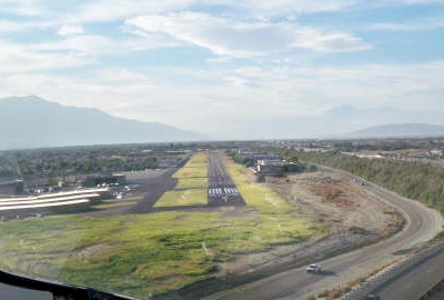
 Airport Diagram might not be current. | |
| Facility Name: | BERMUDA DUNES |
| City Name: | PALM SPRINGS |
| County: | RIVERSIDE |
| State abbrev: | CA |
| State Name: | CALIFORNIA |
| Ownership: | PRIVATELY OWNED |
| Use: | OPEN TO THE PUBLIC |
| Owner's Name: | BERMUDA DUNES AIRPORT CORP |
| Address: | 79-880 AVENUE 42 |
| BERMUDA DUNES, CA 92203 | |
| Owner's Phone: | 760-345-2558 |
| Manager's Name: | ANN GOODWYN |
| Address: | 79-880 AVE. 42 |
| BERMUDA DUNES, CA 92203 | |
| Phone: | 760-345-2558 |
| FAA Region: | WESTERN-PACIFIC |
| FAA Field Office: | LAX |
| Date | Sunrise | Sunset |
|---|---|---|
| 09/24/21 Friday | 6:34 | 18:39 |
| 09/25/21 Saturday | 6:35 | 18:38 |
| 09/26/21 Sunday | 6:36 | 18:36 |
| 09/27/21 Monday | 6:37 | 18:35 |
| 09/28/21 Tuesday | 6:37 | 18:34 |
| 09/29/21 Wednesday | 6:38 | 18:32 |
| 09/30/21 Thursday | 6:39 | 18:31 |
| 10/01/21 Friday | 6:39 | 18:30 |
| 10/02/21 Saturday | 6:40 | 18:28 |
| 10/03/21 Sunday | 6:41 | 18:27 |
| 10/04/21 Monday | 6:42 | 18:26 |
| 10/05/21 Tuesday | 6:42 | 18:24 |
| 10/06/21 Wednesday | 6:43 | 18:23 |
| 10/07/21 Thursday | 6:44 | 18:22 |
| Airport Attendance Schedule | 7 Days A Week SEE RMKS; ATTENDED OCT 1 THRU MAY 31 0600- 2000; JUNE 1 THRU SEPT 30 0600-1930. |
| Airport Status | OPERATIONAL (This Status can change at any time - please check NOTAMS) |
| Airport Lighting Schedule | LIRL RY 10/28 VASI RY 28 ON UNTIL 2200; AFTER 2200 ACTVT - CTAF. |
| Airport Storage Available | Tie Downs, Hanger |
| Extra Services Available | Flight Instruction, Aircraft Rental, Aircraft Sales |
| Wind Indicator | YES - (lighted) |
| Control Tower | NO |
| CTAF Frequency | 122.800 |
| Unicom Frequency | 122.800 |
| Rotating Beacon Color | CLEAR-GREEN (Light Land Airport) |
| Segmented Circle | YES |
| Landing Fee | YES; LNDG FEE BASED ON ACFT TYPE/SIZE. |
| Airport Inspected | STATE - performed by STATE AERONAUTICAL PERSONNEL |
| Inspection Date | 02/12/2020 |
| Type of Fuel Available | Grade 100LL, JET A (freeze point -40C), JET A |
| Airframe Repair Service | MAJOR |
| Power Plant Repair Service | MAJOR |
| Latitude | N3344.9 |
| Longitude | W11616.5 (ESTIMATED) |
| Arpt Elevation | 73ft (SURVEYED) |
| Magnetic Variation | 14E |
| 13 miles E | of PALM SPRINGS |
| Traffic Pattern Altitude | |
| Sectional Chart | LOS ANGELES |
| Operations (Reported) | Yearly | Avg. Daily |
|---|---|---|
| General Aviation Transient | 8960 | 25 |
| General Aviation Local | 5040 | 14 |
| Air Taxi | 0 | 0 |
| Commerical | 0 | 0 |
| Commuter | 0 | 0 |
| Military | 30 | 0 |
| Aircraft based on Field | |
|---|---|
| General Aviation Singles | 56 |
| General Aviation Multi | 5 |
| Jet Aircraft | 0 |
| General Aviation Helicopters | 3 |
| Military Aircraft | 0 |
| Gliders | 1 |
| Ultralights | 1 |
| FSS on field | NO |
| FSS tie-in | RIVERSIDE |
| FSS Phone | 1-800-WX-BRIEF |
| Who issues Notams | RAL |
| Notam D service at airport | YES |
| ARTCC Name | LOS ANGELES |
| Airport Certification | |
| Aircraft Rescue & Firefighting Index | None |
| Airport of Entry | No |
| Custom Landing Rights | No |
| Joint Civil/Military | No |
| Military Landing rights | No |
| THIS AIRPORT HAS BEEN SURVEYED BY THE NATIONAL GEODETIC SURVEY. |
| NO AGRI FLIGHTS EXCP BY PPR ARPT MGR. |
| FOR CD CTC SOCAL APCH AT 800-448-3724. |
| FOR NOISE ABATEMENT PROCEDURES CALL AMGR (760) 345-2558. |
| ARPT CLSD TO TURBINE PWRD ACFT 2300-0600 LCL; EXCP MIL, LAW ENFORCEMENT, EMS ACFT. |
| PARL TWY CLSD ACFT WING SPAN GREATER THAN 68 FT. |
| 24 HR EMERG NR 760-609-8785 |
| FUEL AVBL 0600-2000. |
| ARINC FREQ 129.7 AVBL TO CTC FBO FOR SVCS ONLY |
Airport Communications & Frequencies:
| ||||||||||||||
| Runway: 10 | Runway: 28 | ||
| Mag heading: | 102° | Mag heading: | 282° |
| Rwy Slope: | -.43% Down | Rwy Slope: | .43% Up |
| Approach: | Approach: | ||
| Pattern: | Left Traffic | Pattern: | Left Traffic |
| Markings: | NONPRECISION INSTRUMENT | Markings: | NONPRECISION INSTRUMENT |
| Marking Condition: | GOOD | Marking Condition: | GOOD |
| Arresting Dev: | Arresting Dev: | ||
| Lat & Long: | N3345.1 W11616.9 | Lat. & Long.: | N3344.7 W11616.0 |
| Elev: | 73.0 ft. MSL | Elev: | 51.4 ft. MSL |
| TCH: | TCH: | 33 ft. AGL | |
| Visual Glide Path: | Visual Glide Path: | 3.00 degrees | |
| Displaced Threshold: | No | Displaced Threshold: | 300 feet |
| Touchdown Zone: | YES | Touchdown Zone: | YES |
| Touchdown Elev.: | 73.0 feet | Touchdown Elev.: | 66.0 feet |
| Visual Glide Slope: | Visual Glide Slope: | 2-Box VASI on LEFT side of Runway | |
| RVR Equipment: | RVR Equipment: | ||
| RVV Equipment: | NO | RVV Equipment: | NO |
| Approach Lights: | Approach Lights: | ||
| REIL: | NO | REIL: | YES |
| Centerline Lights: | NO | Centerline Lights: | NO |
| Touchdown lights: | NO | Touchdown lights: | NO |
| Runway Category: | Runway with a Visual Approach | Runway Category: | Runway with a Non-precision Approach |
| Declared Distances: | Declared Distances: | ||
| Obstructions: | FENCE | Obstructions: | ROAD |
| Marked: | NOT Marked/Lighted | Marked: | NOT Marked/Lighted |
| Clearance slope: | Clearance slope: | 14:1; APCH RATIO 28:1 TO DSPLCD THR. | |
| Obstruction height: | 6 feet AGL | Obstruction height: | 37 feet AGL |
| Dist. from runway: | 200 feet | Dist. from runway: | 750 feet |
| Centerline offset: | 125 left of centerline | Centerline offset: | 150 feet right of centerline |
| Comments: | +6' FENCE 125'L. | Comments: | +6' FENCE 125'R. |
Thanks for using FltPlan.com
all rights reserved © 1999-2021 by Flight Plan LLC


