| CUBA MUNI CUBA MO |
| |
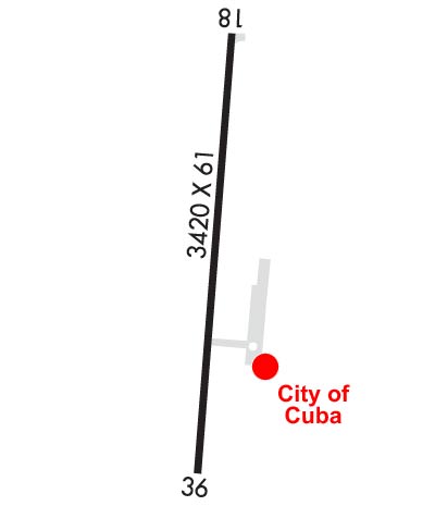
| Lat: N 3804.1 Long: W 09125.7 Elev: 1023 Var: -01 Longest Runway: 3420 | ||
| CTAF: 122.8 | ||
| |||||||||||||||||||||||||||||||||||||||||||||||||||||||||||||
| |||||||||||||||||||||||||||||||||||||||||||||||||||||||||||||
| Rwy | Rwy | |||||||
| 3420x61 | 3420' | 3420x61 | 3420' | |||||
| Runway ID | Single Wheel | Double Wheel | Double Tandem Wheel | Dual Double Wheel |
| 18/36 | 12,500 | N/A | N/A | N/A |
| These numbers are Advisory and are not limits. The Airport Manager should have more accurate Weight Limits | ||||
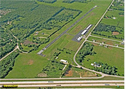
 Airport Diagram might not be current. | |
| Facility Name: | CUBA MUNI |
| City Name: | CUBA |
| County: | CRAWFORD |
| State abbrev: | MO |
| State Name: | MISSOURI |
| Ownership: | PUBLICLY OWNED |
| Use: | OPEN TO THE PUBLIC |
| Owner's Name: | CITY OF CUBA |
| Address: | 202 N SMITH ST., PO BOX K |
| CUBA, MO 65453 | |
| Owner's Phone: | 573-885-7432 |
| Manager's Name: | TRAVIS PRITCHETT |
| Address: | 1312 HWY DD |
| CUBA, MO 65453 | |
| Phone: | 573-885-2479; AFTER HOURS PHONE 573-578-5188 |
| FAA Region: | CENTRAL |
| FAA Field Office: | NONE |
| Date | Sunrise | Sunset |
|---|---|---|
| 09/24/21 Friday | 6:55 | 19:00 |
| 09/25/21 Saturday | 6:56 | 18:58 |
| 09/26/21 Sunday | 6:57 | 18:57 |
| 09/27/21 Monday | 6:58 | 18:55 |
| 09/28/21 Tuesday | 6:58 | 18:54 |
| 09/29/21 Wednesday | 6:59 | 18:52 |
| 09/30/21 Thursday | 7:00 | 18:51 |
| 10/01/21 Friday | 7:01 | 18:49 |
| 10/02/21 Saturday | 7:02 | 18:47 |
| 10/03/21 Sunday | 7:03 | 18:46 |
| 10/04/21 Monday | 7:04 | 18:44 |
| 10/05/21 Tuesday | 7:05 | 18:43 |
| 10/06/21 Wednesday | 7:06 | 18:41 |
| 10/07/21 Thursday | 7:07 | 18:40 |
| Airport Attendance Schedule | SUN 1230-1630, MON-WED 0830-1630, FRI-SAT 0830-1630 |
| Airport Status | OPERATIONAL (This Status can change at any time - please check NOTAMS) |
| Airport Lighting Schedule | MIRL RY 18/36 PRESET ON LOW INTST; TO INCR INTST ACTVT REIL RYS 18 & 36 - CTAF. |
| Airport Storage Available | Tie Downs, Hanger |
| Extra Services Available | Flight Instruction, Aircraft Rental |
| Wind Indicator | YES - (lighted) |
| Control Tower | NO |
| CTAF Frequency | 122.800 |
| Unicom Frequency | 122.800; UNICOM UNMON. |
| Rotating Beacon Color | CLEAR-GREEN (Light Land Airport) |
| Segmented Circle | YES |
| Landing Fee | NO |
| Airport Inspected | STATE - performed by STATE AERONAUTICAL PERSONNEL |
| Inspection Date | 05/28/2019 |
| Type of Fuel Available | Grade 100LL; -10SELF SERVICE FUEL AVBL 24 HRS A DAY |
| Airframe Repair Service | MAJOR |
| Power Plant Repair Service | MAJOR |
| Latitude | N3804.1 |
| Longitude | W09125.7 (ESTIMATED) |
| Arpt Elevation | 1023ft (SURVEYED) |
| Magnetic Variation | 01E |
| 1 miles NW | of CUBA |
| Traffic Pattern Altitude | |
| Sectional Chart | KANSAS CITY |
| Operations (Reported) | Yearly | Avg. Daily |
|---|---|---|
| General Aviation Transient | 1200 | 3 |
| General Aviation Local | 2500 | 7 |
| Air Taxi | 0 | 0 |
| Commerical | 0 | 0 |
| Commuter | 0 | 0 |
| Military | 30 | 0 |
| Aircraft based on Field | |
|---|---|
| General Aviation Singles | 17 |
| General Aviation Multi | 0 |
| Jet Aircraft | 0 |
| General Aviation Helicopters | 0 |
| Military Aircraft | 0 |
| Gliders | 0 |
| Ultralights | 0 |
| FSS on field | NO |
| FSS tie-in | SAINT LOUIS |
| FSS Phone | 1-800-WX-BRIEF |
| Who issues Notams | STL |
| Notam D service at airport | YES |
| ARTCC Name | KANSAS CITY |
| Airport Certification | |
| Aircraft Rescue & Firefighting Index | None |
| Airport of Entry | No |
| Custom Landing Rights | No |
| Joint Civil/Military | No |
| Military Landing rights | YES |
| NATIONAL PLAN OF INTEGRATED AIRPORT SYSTEMS (NPIAS) |
| GRANT AGREEMENTS UNDER FAAP/ADAP/AIP |
| ASSURANCES PURSUANT TO TITLE VI, CIVIL RIGHTS ACT OF 1964 |
| FOR CD CTC KANSAS CITY ARTCC AT 913-254-8508. |
Airport Communications & Frequencies:
| |||||||||
| Runway: 18 | Runway: 36 | ||
| Mag heading: | 185° | Mag heading: | 5° |
| Rwy Slope: | -.11% Down | Rwy Slope: | .11% Up |
| Approach: | Approach: | ||
| Pattern: | Left Traffic | Pattern: | Left Traffic |
| Markings: | NONPRECISION INSTRUMENT | Markings: | NONPRECISION INSTRUMENT |
| Marking Condition: | GOOD | Marking Condition: | GOOD |
| Arresting Dev: | Arresting Dev: | ||
| Lat & Long: | N3804.4 W09125.7 | Lat. & Long.: | N3803.8 W09125.8 |
| Elev: | 1023.0 ft. MSL | Elev: | 1019.4 ft. MSL |
| TCH: | 44 ft. AGL | TCH: | 50 ft. AGL |
| Visual Glide Path: | 3.00 degrees | Visual Glide Path: | 3.00 degrees |
| Displaced Threshold: | No | Displaced Threshold: | No |
| Touchdown Zone: | YES | Touchdown Zone: | YES |
| Touchdown Elev.: | 1023.0 feet | Touchdown Elev.: | 1023.4 feet |
| Visual Glide Slope: | 2-Light PAPI on LEFT side of Runway | Visual Glide Slope: | 2-Light PAPI on LEFT side of Runway |
| RVR Equipment: | RVR Equipment: | ||
| RVV Equipment: | NO | RVV Equipment: | NO |
| Approach Lights: | Approach Lights: | ||
| REIL: | YES; REIL OTS INDEFLY. | REIL: | YES; REIL OTS INDEFLY. |
| Centerline Lights: | NO | Centerline Lights: | NO |
| Touchdown lights: | NO | Touchdown lights: | NO |
| Runway Category: | Runway with a Non-precision Approach | Runway Category: | Runway with a Non-precision Approach |
| Declared Distances: | Declared Distances: | ||
| Obstructions: | Obstructions: | TREES | |
| Marked: | Marked: | NOT Marked/Lighted | |
| Clearance slope: | 20:1 | Clearance slope: | 7:1 |
| Obstruction height: | Obstruction height: | 51 feet AGL | |
| Dist. from runway: | Dist. from runway: | 598 feet | |
| Centerline offset: | Centerline offset: | 150 feet left of centerline | |
| Comments: | Comments: |
Thanks for using FltPlan.com
all rights reserved © 1999-2021 by Flight Plan LLC