
| GLENNS FERRY MUNI GLENNS FERRY ID |
| |
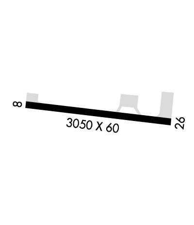
| Lat: N 4256.6 Long: W 11519.8 Elev: 2536 Var: -17 Longest Runway: 3050 | ||
| CTAF: 122.9 | ||
| ||||||||||||||||||||||||||||||||
| ||||||||||||||||||||||||||||||||
| Rwy | Rwy | |||||||
| 3050x60 | 3050' | 3050x60 | 3050' | |||||
| Runway ID | Single Wheel | Double Wheel | Double Tandem Wheel | Dual Double Wheel |
| 08/26 | N/A | N/A | N/A | N/A |
| These numbers are Advisory and are not limits. The Airport Manager should have more accurate Weight Limits | ||||
| FltPlan does not have IFR approach charts available for KU89. |
 Airport Diagram might not be current. | |
| Facility Name: | GLENNS FERRY MUNI |
| City Name: | GLENNS FERRY |
| County: | ELMORE |
| State abbrev: | ID |
| State Name: | IDAHO |
| Ownership: | PUBLICLY OWNED |
| Use: | OPEN TO THE PUBLIC |
| Owner's Name: | CITY OF GLENNS FERRY |
| Address: | 110 E 2ND AVE |
| GLENNS FERRY, ID 83623 | |
| Owner's Phone: | 208-366-7418 |
| Manager's Name: | BRIAN REID |
| Address: | 11850 NW TOUCHNGO AVE |
| BOISE, ID 83716 | |
| Phone: | 208-899-1177 |
| FAA Region: | NORTHWEST MOUNTAIN |
| FAA Field Office: | HLN |
| Date | Sunrise | Sunset |
|---|---|---|
| 06/08/26 Monday | 6:03 | 21:18 |
| 06/09/26 Tuesday | 6:02 | 21:19 |
| 06/10/26 Wednesday | 6:02 | 21:20 |
| 06/11/26 Thursday | 6:02 | 21:20 |
| 06/12/26 Friday | 6:02 | 21:21 |
| 06/13/26 Saturday | 6:02 | 21:21 |
| 06/14/26 Sunday | 6:02 | 21:22 |
| 06/15/26 Monday | 6:02 | 21:22 |
| 06/16/26 Tuesday | 6:02 | 21:22 |
| 06/17/26 Wednesday | 6:02 | 21:23 |
| 06/18/26 Thursday | 6:02 | 21:23 |
| 06/19/26 Friday | 6:02 | 21:23 |
| 06/20/26 Saturday | 6:02 | 21:24 |
| 06/21/26 Sunday | 6:02 | 21:24 |
| Airport Attendance Schedule | UNATTENDED |
| Airport Status | OPERATIONAL (This Status can change at any time - please check NOTAMS) |
| Airport Lighting Schedule | ACTVT MIRL RY 08/26 - CTAF.; ACTIVATE BEACON-CTAF, |
| Airport Storage Available | Tie Downs |
| Extra Services Available | Crop Dusting |
| Wind Indicator | YES - (unlit) |
| Control Tower | NO |
| CTAF Frequency | 122.900 |
| Unicom Frequency | |
| Rotating Beacon Color | WG |
| Segmented Circle | YES; NON-STD PAINTED TIRES. |
| Landing Fee | NO |
| Airport Inspected | STATE - performed by STATE AERONAUTICAL PERSONNEL |
| Inspection Date | 03/28/2024 |
| Type of Fuel Available | None |
| Airframe Repair Service | NONE |
| Power Plant Repair Service | NONE |
| Latitude | N4256.6 |
| Longitude | W11519.8 (ESTIMATED) |
| Arpt Elevation | 2536ft (SURVEYED) |
| Magnetic Variation | 17E |
| 1 miles SW | of GLENNS FERRY |
| Traffic Pattern Altitude | |
| Sectional Chart | SALT LAKE CITY |
| Operations (Reported) | Yearly | Avg. Daily |
|---|---|---|
| General Aviation Transient | 0 | 0 |
| General Aviation Local | 0 | 0 |
| Air Taxi | 0 | 0 |
| Commerical | 0 | 0 |
| Commuter | 0 | 0 |
| Military | 0 | 0 |
| Aircraft based on Field | |
|---|---|
| General Aviation Singles | 0 |
| General Aviation Multi | 0 |
| Jet Aircraft | 0 |
| General Aviation Helicopters | 0 |
| Military Aircraft | 0 |
| Gliders | 0 |
| Ultralights | 0 |
| FSS on field | NO |
| FSS tie-in | BOISE |
| FSS Phone | 1-800-WX-BRIEF |
| Who issues Notams | BOI |
| Notam D service at airport | YES |
| ARTCC Name | SALT LAKE CITY |
| Airport Certification | |
| Aircraft Rescue & Firefighting Index | None |
| Airport of Entry | No |
| Custom Landing Rights | No |
| Joint Civil/Military | No |
| Military Landing rights | No |
| GRANT AGREEMENT HAS EXPIRED; HOWEVER, AGREEMENT REMAINS IN EFFECT FOR THIS FACILITY AS LONG AS IT IS PUBLIC USE. |
| RWY 08 +150' PLINE CROSSES SNAKE RIVER CANYON APPROX 5 MILES DOWNRIVER. |
| RY 08/26 DISTANCE TO GO MARKERS EVERY 1000 FT S SIDE OF RY. |
| FOR CD CTC MUO RAPCON AT 208-828-6096 WHEN OPN. SALT LAKE ARTCC AT 801-320-2568 WHEN CLSD. |
| Runway: 08 | Runway: 26 | ||
| Mag heading: | N/A | Mag heading: | N/A |
| Approach: | Approach: | ||
| Pattern: | Left Traffic | Pattern: | Left Traffic |
| Markings: | BASIC | Markings: | BASIC |
| Marking Condition: | GOOD | Marking Condition: | GOOD |
| Arresting Dev: | Arresting Dev: | ||
| Lat & Long: | N4256.6 W11520.1 | Lat. & Long.: | N4256.6 W11519.5 |
| Elev: | N/A | Elev: | N/A |
| TCH: | TCH: | ||
| Visual Glide Path: | Visual Glide Path: | ||
| Displaced Threshold: | No | Displaced Threshold: | No |
| Touchdown Zone: | NO | Touchdown Zone: | NO |
| Touchdown Elev.: | Touchdown Elev.: | ||
| Visual Glide Slope: | Visual Glide Slope: | ||
| RVR Equipment: | RVR Equipment: | ||
| RVV Equipment: | NO | RVV Equipment: | NO |
| Approach Lights: | Approach Lights: | ||
| REIL: | NO | REIL: | NO |
| Centerline Lights: | NO | Centerline Lights: | NO |
| Touchdown lights: | NO | Touchdown lights: | NO |
| Runway Category: | Runway with a Visual Approach | Runway Category: | Runway with a Visual Approach |
| Declared Distances: | Declared Distances: | ||
| Obstructions: | Obstructions: | TREES | |
| Marked: | Marked: | NOT Marked/Lighted | |
| Clearance slope: | 20:1 | Clearance slope: | 13:1 |
| Obstruction height: | Obstruction height: | 80 feet AGL | |
| Dist. from runway: | Dist. from runway: | 1250 feet | |
| Centerline offset: | Centerline offset: | ||
| Comments: | +4' FENCE AT 95' ON CNTRLN. | Comments: | +4 FT FENCE AT 75 FT ON CNTRLN; 15 FT ROAD AT 85 FT ON CNTRLN. |
Thanks for using FltPlan.com
all rights reserved © 1999-2026 by Flight Plan LLC
