
| ALLEN H TIGERT SODA SPRINGS ID |
| |
| Lat: N 4238.9 Long: W 11134.9 Elev: 5843 Var: -15 Longest Runway: 3500 | ||
| CTAF: 122.8 | ||
| ||||||||||||||||||||||||||||||||||||||||||||
| ||||||||||||||||||||||||||||||||||||||||||||
| Rwy | Rwy | |||||||
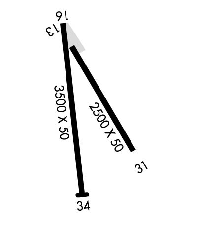
| 2500x50 | 2500' | 2500x50 | 2500' | |||||
| 3500x50 | 3200' | 3500x50 | 3500' | |||||
| Runway ID | Single Wheel | Double Wheel | Double Tandem Wheel | Dual Double Wheel |
| 13/31 | N/A | N/A | N/A | N/A |
| 16/34 | 12,000 | N/A | N/A | N/A |
| These numbers are Advisory and are not limits. The Airport Manager should have more accurate Weight Limits | ||||
| FltPlan does not have IFR approach charts available for KU78. |
 Airport Diagram might not be current. | |
| Facility Name: | ALLEN H TIGERT |
| City Name: | SODA SPRINGS |
| County: | CARIBOU |
| State abbrev: | ID |
| State Name: | IDAHO |
| Ownership: | PUBLICLY OWNED |
| Use: | OPEN TO THE PUBLIC |
| Owner's Name: | CITY OF SODA SPRINGS |
| Address: | 9 WEST 2ND SOUTH |
| SODA SPRINGS, ID 83276 | |
| Owner's Phone: | 208-547-2600 |
| Manager's Name: | ALAN SKINNER |
| Address: | 9 WEST 2ND SOUTH |
| SODA SPRINGS, ID 83276 | |
| Phone: | 208-547-2600 |
| FAA Region: | NORTHWEST MOUNTAIN |
| FAA Field Office: | HLN |
| Date | Sunrise | Sunset |
|---|---|---|
| 09/24/21 Friday | 7:16 | 19:20 |
| 09/25/21 Saturday | 7:17 | 19:19 |
| 09/26/21 Sunday | 7:18 | 19:17 |
| 09/27/21 Monday | 7:19 | 19:15 |
| 09/28/21 Tuesday | 7:20 | 19:13 |
| 09/29/21 Wednesday | 7:21 | 19:11 |
| 09/30/21 Thursday | 7:22 | 19:10 |
| 10/01/21 Friday | 7:23 | 19:08 |
| 10/02/21 Saturday | 7:24 | 19:06 |
| 10/03/21 Sunday | 7:26 | 19:04 |
| 10/04/21 Monday | 7:27 | 19:03 |
| 10/05/21 Tuesday | 7:28 | 19:01 |
| 10/06/21 Wednesday | 7:29 | 18:59 |
| 10/07/21 Thursday | 7:30 | 18:58 |
| Airport Attendance Schedule | UNATTENDED; CALL 208-547-2600 OR 208-221-4494 FOR SVC. |
| Airport Status | OPERATIONAL (This Status can change at any time - please check NOTAMS) |
| Airport Lighting Schedule | SS-SR |
| Airport Storage Available | Tie Downs |
| Extra Services Available | NONE |
| Wind Indicator | YES - (lighted) |
| Control Tower | NO |
| CTAF Frequency | 122.800 |
| Unicom Frequency | 122.800 |
| Rotating Beacon Color | CLEAR-GREEN (Light Land Airport); BEACON OUT OF SERVICE INDEFLY. |
| Segmented Circle | YES |
| Landing Fee | NO |
| Airport Inspected | STATE - performed by STATE AERONAUTICAL PERSONNEL |
| Inspection Date | 06/10/2021 |
| Type of Fuel Available | Grade 100LL |
| Airframe Repair Service | NONE |
| Power Plant Repair Service | NONE |
| Latitude | N4238.9 |
| Longitude | W11134.9 (ESTIMATED) |
| Arpt Elevation | 5843ft (ESTIMATED) |
| Magnetic Variation | 15E |
| 1 miles SE | of SODA SPRINGS |
| Traffic Pattern Altitude | |
| Sectional Chart | SALT LAKE CITY |
| Operations (Reported) | Yearly | Avg. Daily |
|---|---|---|
| General Aviation Transient | 3500 | 10 |
| General Aviation Local | 2300 | 6 |
| Air Taxi | 0 | 0 |
| Commerical | 0 | 0 |
| Commuter | 0 | 0 |
| Military | 0 | 0 |
| Aircraft based on Field | |
|---|---|
| General Aviation Singles | 6 |
| General Aviation Multi | 0 |
| Jet Aircraft | 0 |
| General Aviation Helicopters | 0 |
| Military Aircraft | 0 |
| Gliders | 0 |
| Ultralights | 0 |
| FSS on field | NO |
| FSS tie-in | BOISE |
| FSS Phone | 1-800-WX-BRIEF |
| Who issues Notams | BOI |
| Notam D service at airport | YES |
| ARTCC Name | SALT LAKE CITY |
| Airport Certification | |
| Aircraft Rescue & Firefighting Index | None |
| Airport of Entry | No |
| Custom Landing Rights | No |
| Joint Civil/Military | No |
| Military Landing rights | No |
| GRANT AGREEMENT HAS EXPIRED; HOWEVER, AGREEMENT REMAINS IN EFFECT FOR THIS FACILITY AS LONG AS IT IS PUBLIC USE. |
| SHARPLY DESCENDING TRRN NEAR END RYS 31 & 34. |
| NUMEROUS OBSTNS ON APCH TO RYS 13 & 16. |
| FOR CD CTC SALT LAKE ARTCC AT 801-320-2568. |
| RWY 13/3 1 RWY IS FULL OF CRACKS, OLD, AND NEW, UNTREATED, HAS NO MARKINGS, AND MANY AREAS WHERE THE TOP LAYER OF ASPH IS FLAKING OFF. |
| RWY 16/3 4 RWY IS IN BAD SHAPE DUE TO POOR MARKINGS, UNTREATED CRACKS, AND FLAKING OF THE ASPHALT. |
| RWY 16/3 4 NSTD LIRL FIRST 300 FT RY 16 NOT LIGHTED. RWY 16/34 RWY LIGHTS AND REILS OUT OF SERVICE INDEFLY. NO RWY LIGHTS AVAILABLE. |
| Runway: 13 | Runway: 31 | ||
| Mag heading: | N/A | Mag heading: | N/A |
| Rwy Slope: | .36% Up | Rwy Slope: | -.36% Down |
| Approach: | Approach: | ||
| Pattern: | Left Traffic | Pattern: | Left Traffic |
| Markings: | NONE | Markings: | NONE |
| Marking Condition: | Marking Condition: | ||
| Arresting Dev: | Arresting Dev: | ||
| Lat & Long: | N4239.1 W11135.0 | Lat. & Long.: | N4238.7 W11134.7 |
| Elev: | 5834.0 ft. MSL | Elev: | 5843.0 ft. MSL |
| TCH: | TCH: | ||
| Visual Glide Path: | Visual Glide Path: | ||
| Displaced Threshold: | No | Displaced Threshold: | No |
| Touchdown Zone: | NO | Touchdown Zone: | NO |
| Touchdown Elev.: | Touchdown Elev.: | ||
| Visual Glide Slope: | Visual Glide Slope: | ||
| RVR Equipment: | RVR Equipment: | ||
| RVV Equipment: | NO | RVV Equipment: | NO |
| Approach Lights: | Approach Lights: | ||
| REIL: | NO | REIL: | NO |
| Centerline Lights: | NO | Centerline Lights: | NO |
| Touchdown lights: | NO | Touchdown lights: | NO |
| Runway Category: | Runway with a Visual Approach | Runway Category: | Runway with a Visual Approach |
| Declared Distances: | Declared Distances: | ||
| Obstructions: | POLE | Obstructions: | PLINE |
| Marked: | NOT Marked/Lighted | Marked: | NOT Marked/Lighted |
| Clearance slope: | 5:1 | Clearance slope: | 9:1 |
| Obstruction height: | 45 feet AGL | Obstruction height: | 40 feet AGL |
| Dist. from runway: | 450 feet | Dist. from runway: | 600 feet |
| Centerline offset: | 50 left of centerline | Centerline offset: | |
| Comments: | +12' PARKED ACFT AT 0' 115' L. | Comments: | +9' ROAD AT 60' ON CNTRLN. |
| Runway: 16 | Runway: 34 | ||
| Mag heading: | N/A | Mag heading: | N/A |
| Rwy Slope: | .29% Up | Rwy Slope: | -.29% Down |
| Approach: | Approach: | ||
| Pattern: | Left Traffic | Pattern: | Left Traffic |
| Markings: | BASIC | Markings: | BASIC |
| Marking Condition: | POOR; MARKINGS ARE VERY DFCLT TO SEE - PAINT IS ALMOST ALL GONE. | Marking Condition: | POOR; MARKINGS ARE VERY DFCLT TO SEE - PAINT IS ALMOST ALL GONE. |
| Arresting Dev: | Arresting Dev: | ||
| Lat & Long: | N4239.2 W11135.0 | Lat. & Long.: | N4238.6 W11134.9 |
| Elev: | 5833.0 ft. MSL | Elev: | 5843.0 ft. MSL |
| TCH: | 25 ft. AGL | TCH: | 44 ft. AGL |
| Visual Glide Path: | 4.00 degrees | Visual Glide Path: | 3.00 degrees |
| Displaced Threshold: | 300 feet; DTHR 300 FT AT NIGHT. | Displaced Threshold: | No |
| Touchdown Zone: | NO | Touchdown Zone: | NO |
| Touchdown Elev.: | Touchdown Elev.: | ||
| Visual Glide Slope: | TRI-COLOR VASI ON LEFT SIDE OF RUNWAY; TRI COLOR VASI INOPERABLE INDEFINITELY | Visual Glide Slope: | TRI-COLOR VASI ON LEFT SIDE OF RUNWAY; TRI COLOR VASI INOPERABLE INDEFINITELY |
| RVR Equipment: | RVR Equipment: | ||
| RVV Equipment: | NO | RVV Equipment: | NO |
| Approach Lights: | Approach Lights: | ||
| REIL: | NO | REIL: | NO |
| Centerline Lights: | NO | Centerline Lights: | NO |
| Touchdown lights: | NO | Touchdown lights: | NO |
| Runway Category: | Runway with a Visual Approach | Runway Category: | Runway with a Visual Approach |
| Declared Distances: | Declared Distances: | ||
| Obstructions: | ROAD; +100' BARN/GRAIN ELEVATOR AT 1000', 400'L. | Obstructions: | |
| Marked: | NOT Marked/Lighted | Marked: | |
| Clearance slope: | 31:1 FM DSPLCD THR. | Clearance slope: | 50:1 |
| Obstruction height: | 16 feet AGL | Obstruction height: | |
| Dist. from runway: | 200 feet | Dist. from runway: | |
| Centerline offset: | 100 right of centerline | Centerline offset: | |
| Comments: | +16' HWY CROSSES PRIM SFC 50' FM EOR; NUMEROUS HIGH VEHICLES; NUMEROUS CLOSE IN OBSTNS ON APCH TO RY 16. | Comments: |
Thanks for using FltPlan.com
all rights reserved © 1999-2021 by Flight Plan LLC
