
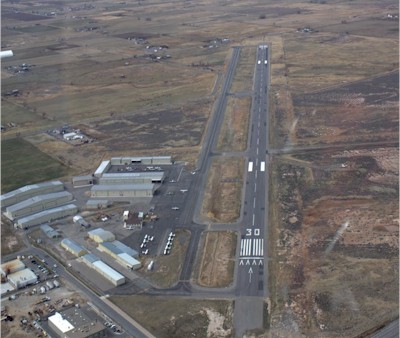
| SPANISH FORK-SPRINGVILLE SPANISH FORK UT |
| |
| Lat: N 4008.7 Long: W 11140.1 Elev: 4529 Var: -14 Longest Runway: 6500 | ||
| CTAF: 122.9 | ||
| |||||||||||||||||||||||||||||||||||||||||||||||||||||||||||||
| |||||||||||||||||||||||||||||||||||||||||||||||||||||||||||||
| Rwy | Rwy | |||||||
| 6500x100 | 6500' | 6500x100 | 6500' | |||||
| Runway ID | Single Wheel | Double Wheel | Double Tandem Wheel | Dual Double Wheel |
| These numbers are Advisory and are not limits. The Airport Manager should have more accurate Weight Limits | ||||
| FltPlan does not have IFR approach charts available for KU77. |
| Facility Name: | SPANISH FORK-SPRINGVILLE-WOODHOUSE FIELD |
| City Name: | SPANISH FORK |
| County: | UTAH |
| State abbrev: | UT |
| State Name: | UTAH |
| Ownership: | PUBLICLY OWNED |
| Use: | OPEN TO THE PUBLIC |
| Owner's Name: | SPANISH FORK & SPRINGVILLE |
| Address: | 2050 N. 300 W |
| SPANISH FORK, UT 84660 | |
| Owner's Phone: | 801-798-5000 |
| Manager's Name: | CRIS CHILD |
| Address: | 2050 NORTH 300 WEST |
| SPANISH FORK, UT 84660 | |
| Phone: | 801-420-8888 |
| FAA Region: | NORTHWEST MOUNTAIN |
| FAA Field Office: | DEN |
| Date | Sunrise | Sunset |
|---|---|---|
| 12/06/17 Wednesday | 7:34 | 17:01 |
| 12/07/17 Thursday | 7:35 | 17:01 |
| 12/08/17 Friday | 7:36 | 17:01 |
| 12/09/17 Saturday | 7:37 | 17:01 |
| 12/10/17 Sunday | 7:38 | 17:01 |
| 12/11/17 Monday | 7:39 | 17:01 |
| 12/12/17 Tuesday | 7:40 | 17:01 |
| 12/13/17 Wednesday | 7:40 | 17:01 |
| 12/14/17 Thursday | 7:41 | 17:02 |
| 12/15/17 Friday | 7:42 | 17:02 |
| 12/16/17 Saturday | 7:42 | 17:02 |
| 12/17/17 Sunday | 7:43 | 17:03 |
| 12/18/17 Monday | 7:44 | 17:03 |
| 12/19/17 Tuesday | 7:44 | 17:03 |
| Airport Attendance Schedule | MON-SAT 0900-1700 |
| Airport Status | OPERATIONAL (This Status can change at any time - please check NOTAMS) |
| Airport Lighting Schedule | ACTVT MIRL, REILS AND PAPI RY 12/30 - CTAF. |
| Airport Storage Available | Tie Downs, Hanger |
| Extra Services Available | Flight Instruction, Aircraft Rental |
| Wind Indicator | YES - (lighted) |
| Control Tower | NO |
| CTAF Frequency | 122.900 |
| Unicom Frequency | |
| Rotating Beacon Color | CLEAR-GREEN (Light Land Airport) |
| Segmented Circle | YES |
| Landing Fee | NO |
| Airport Inspected | STATE - performed by STATE AERONAUTICAL PERSONNEL |
| Inspection Date | 08/09/2017 |
| Type of Fuel Available | Grade 100LL, JET A (freeze point -40C); SELF SERVE 100LL AVAILABLE ANYTIME WITH CREDIT CARD. |
| Airframe Repair Service | MAJOR |
| Power Plant Repair Service | MAJOR |
| Latitude | N4008.7 |
| Longitude | W11140.1 (ESTIMATED) |
| Arpt Elevation | 4529ft (SURVEYED) |
| Magnetic Variation | 14E |
| 2 miles NW | of SPANISH FORK |
| Traffic Pattern Altitude | TPA FOR FIXED WING ACFT IS 1000 FT AGL; TPA FOR ROTARY WING ACFT IS 500 FT AGL. |
| Sectional Chart | SALT LAKE CITY |
| Operations (Reported) | Yearly | Avg. Daily |
|---|---|---|
| General Aviation Transient | 11752 | 32 |
| General Aviation Local | 15412 | 42 |
| Air Taxi | 0 | 0 |
| Commerical | 0 | 0 |
| Commuter | 0 | 0 |
| Military | 100 | 0 |
| Aircraft based on Field | |
|---|---|
| General Aviation Singles | 123 |
| General Aviation Multi | 11 |
| Jet Aircraft | 2 |
| General Aviation Helicopters | 12 |
| Military Aircraft | 0 |
| Gliders | 2 |
| Ultralights | 2 |
| FSS on field | NO |
| FSS tie-in | CEDAR CITY |
| FSS Phone | 1-800-WX-BRIEF |
| Who issues Notams | CDC |
| Notam D service at airport | YES |
| ARTCC Name | SALT LAKE CITY |
| Airport Certification | |
| Aircraft Rescue & Firefighting Index | None |
| Airport of Entry | No |
| Custom Landing Rights | No |
| Joint Civil/Military | No |
| Military Landing rights | YES |
| NATIONAL PLAN OF INTEGRATED AIRPORT SYSTEMS (NPIAS) |
| GRANT AGREEMENTS UNDER FAAP/ADAP/AIP |
| ASSURANCES PURSUANT TO TITLE VI, CIVIL RIGHTS ACT OF 1964 |
| DEER ON & INVOF ARPT. |
| NOISE ABATEMENT PROCEDURES IN EFFECT. CALL AMGR 801-798-9888. |
| DEC-FEB EXPECT UP TO 24 HRS AFTER STORM BEFORE RY PLOWING. RESIDUAL SNOW & ICE ON RY AFTER PLOWING. FOR STATUS CALL 801-798-9888/9. |
| FOR CD CTC SLC APCH AT 801-325-9670. |
| RWY 30 ROTARY WING ACFT ARRIVING RWY 30 MUST CTC ARPT PIOR TO ARRIVAL FOR TFC PATTERN INFORMATION. |
| Runway: 12 | Runway: 30 | ||
| Mag heading: | N/A | Mag heading: | N/A |
| Rwy Slope: | .08% Up | Rwy Slope: | -.08% Down |
| Approach: | Approach: | ||
| Pattern: | Left Traffic | Pattern: | Left Traffic |
| Markings: | NONPRECISION INSTRUMENT | Markings: | NONPRECISION INSTRUMENT |
| Marking Condition: | GOOD | Marking Condition: | GOOD |
| Arresting Dev: | Arresting Dev: | ||
| Lat & Long: | N4009.1 W11140.6 | Lat. & Long.: | N4008.3 W11139.5 |
| Elev: | 4523.9 ft. MSL | Elev: | 4528.8 ft. MSL |
| TCH: | 40 ft. AGL | TCH: | 40 ft. AGL |
| Visual Glide Path: | 3.00 degrees | Visual Glide Path: | 3.00 degrees |
| Displaced Threshold: | No | Displaced Threshold: | No |
| Touchdown Zone: | NO | Touchdown Zone: | NO |
| Touchdown Elev.: | Touchdown Elev.: | ||
| Visual Glide Slope: | 4-Light PAPI on LEFT side of Runway | Visual Glide Slope: | 4-Light PAPI on LEFT side of Runway |
| RVR Equipment: | RVR Equipment: | ||
| RVV Equipment: | NO | RVV Equipment: | NO |
| Approach Lights: | Approach Lights: | ||
| REIL: | YES | REIL: | YES |
| Centerline Lights: | NO | Centerline Lights: | NO |
| Touchdown lights: | NO | Touchdown lights: | NO |
| Runway Category: | Runway with a Visual Approach | Runway Category: | Runway with a Visual Approach |
| Declared Distances: | Declared Distances: |
Thanks for using FltPlan.com
all rights reserved © 1999-2017 by Flight Plan LLC