
| CASCADE CASCADE ID |
| |
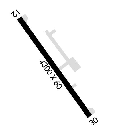
| Lat: N 4429.5 Long: W 11600.9 Elev: 4748 Var: -17 Longest Runway: 4300 | ||
| CTAF: 122.9 | ||
| ||||||||||||||||||||||||||||||||||||||||||||
| ||||||||||||||||||||||||||||||||||||||||||||
| Rwy | Rwy | |||||||
| 4300x60 | 4300' | 4300x60 | 4300' | |||||
| Runway ID | Single Wheel | Double Wheel | Double Tandem Wheel | Dual Double Wheel |
| 12/30 | 12,500 | N/A | N/A | N/A |
| These numbers are Advisory and are not limits. The Airport Manager should have more accurate Weight Limits | ||||
| FltPlan does not have IFR approach charts available for KU70. |
 Airport Diagram might not be current. | |
| Facility Name: | CASCADE |
| City Name: | CASCADE |
| County: | VALLEY |
| State abbrev: | ID |
| State Name: | IDAHO |
| Ownership: | PUBLICLY OWNED |
| Use: | OPEN TO THE PUBLIC |
| Owner's Name: | CITY OF CASCADE |
| Address: | PO BOX 649 |
| CASCADE, ID 83611 | |
| Owner's Phone: | 208-382-4279 |
| Manager's Name: | MIKE ARNOLD |
| Address: | BOX 1094 |
| CASCADE, ID 83611 | |
| Phone: | 208-382-4844 |
| FAA Region: | NORTHWEST MOUNTAIN |
| FAA Field Office: | HLN |
| Date | Sunrise | Sunset |
|---|---|---|
| 06/08/26 Monday | 6:00 | 21:27 |
| 06/09/26 Tuesday | 5:59 | 21:27 |
| 06/10/26 Wednesday | 5:59 | 21:28 |
| 06/11/26 Thursday | 5:59 | 21:29 |
| 06/12/26 Friday | 5:59 | 21:29 |
| 06/13/26 Saturday | 5:59 | 21:30 |
| 06/14/26 Sunday | 5:59 | 21:30 |
| 06/15/26 Monday | 5:59 | 21:31 |
| 06/16/26 Tuesday | 5:59 | 21:31 |
| 06/17/26 Wednesday | 5:59 | 21:31 |
| 06/18/26 Thursday | 5:59 | 21:32 |
| 06/19/26 Friday | 5:59 | 21:32 |
| 06/20/26 Saturday | 5:59 | 21:32 |
| 06/21/26 Sunday | 5:59 | 21:32 |
| Airport Attendance Schedule | DEC-APR 7 Days A Week 0900-1700, MAY-NOV 7 Days A Week 0800-1800 |
| Airport Status | OPERATIONAL (This Status can change at any time - please check NOTAMS) |
| Airport Lighting Schedule | ACTVT MIRL RWY 12/30 AND WINDSOCK LIGHTS - CTAF. |
| Airport Storage Available | Tie Downs |
| Extra Services Available | Charter, Flight Instruction |
| Wind Indicator | YES - (lighted) |
| Control Tower | NO |
| CTAF Frequency | 122.900 |
| Unicom Frequency | |
| Rotating Beacon Color | WG |
| Segmented Circle | YES |
| Landing Fee | NO |
| Airport Inspected | STATE - performed by STATE AERONAUTICAL PERSONNEL |
| Inspection Date | 05/03/2023 |
| Type of Fuel Available | Grade 100LL, JET A (freeze point -40C) |
| Airframe Repair Service | MAJOR |
| Power Plant Repair Service | MAJOR |
| Latitude | N4429.5 |
| Longitude | W11600.9 (ESTIMATED) |
| Arpt Elevation | 4748ft (SURVEYED) |
| Magnetic Variation | 17E |
| 2 miles SE | of CASCADE |
| Traffic Pattern Altitude | |
| Sectional Chart | SALT LAKE CITY |
| Operations (Reported) | Yearly | Avg. Daily |
|---|---|---|
| General Aviation Transient | 0 | 0 |
| General Aviation Local | 0 | 0 |
| Air Taxi | 0 | 0 |
| Commerical | 0 | 0 |
| Commuter | 0 | 0 |
| Military | 0 | 0 |
| Aircraft based on Field | |
|---|---|
| General Aviation Singles | 0 |
| General Aviation Multi | 0 |
| Jet Aircraft | 0 |
| General Aviation Helicopters | 0 |
| Military Aircraft | 0 |
| Gliders | 0 |
| Ultralights | 0 |
| FSS on field | NO |
| FSS tie-in | BOISE |
| FSS Phone | 1-800-WX-BRIEF |
| Who issues Notams | BOI |
| Notam D service at airport | YES |
| ARTCC Name | SALT LAKE CITY |
| Airport Certification | |
| Aircraft Rescue & Firefighting Index | None |
| Airport of Entry | No |
| Custom Landing Rights | No |
| Joint Civil/Military | No |
| Military Landing rights | No |
| NATIONAL PLAN OF INTEGRATED AIRPORT SYSTEMS (NPIAS) |
| GRANT AGREEMENTS UNDER FAAP/ADAP/AIP |
| ASSURANCES PURSUANT TO TITLE VI, CIVIL RIGHTS ACT OF 1964 |
| RETROREFLECTIVE REFLECTORS ON TWYS & RAMP EDGES. |
| RWY 12 +300 FT TIMBERED RDG AT 1.25 MIS ON CNTRLN. |
| RWY 12/3 0 TO AVOID APCH/DEP OVR TOWN; LND RY 30 & DEP RY 12 WHEN WND CONDS PMT. |
| Runway: 12 | Runway: 30 | ||
| Mag heading: | N/A | Mag heading: | N/A |
| Rwy Slope: | .00% | Rwy Slope: | .00% |
| Approach: | Approach: | ||
| Pattern: | Left Traffic | Pattern: | Right Traffic |
| Markings: | BASIC | Markings: | BASIC |
| Marking Condition: | GOOD | Marking Condition: | GOOD |
| Arresting Dev: | Arresting Dev: | ||
| Lat & Long: | N4429.8 W11601.2 | Lat. & Long.: | N4429.3 W11600.5 |
| Elev: | 4742.0 ft. MSL | Elev: | 4742.0 ft. MSL |
| TCH: | TCH: | ||
| Visual Glide Path: | Visual Glide Path: | ||
| Displaced Threshold: | No | Displaced Threshold: | No |
| Touchdown Zone: | YES | Touchdown Zone: | YES |
| Touchdown Elev.: | 4742.0 feet | Touchdown Elev.: | 4742.0 feet |
| Visual Glide Slope: | Visual Glide Slope: | ||
| RVR Equipment: | RVR Equipment: | ||
| RVV Equipment: | NO | RVV Equipment: | NO |
| Approach Lights: | Approach Lights: | ||
| REIL: | NO | REIL: | NO |
| Centerline Lights: | NO | Centerline Lights: | NO |
| Touchdown lights: | NO | Touchdown lights: | NO |
| Runway Category: | Runway with a Visual Approach | Runway Category: | Runway with a Visual Approach |
| Declared Distances: | Declared Distances: |
Thanks for using FltPlan.com
all rights reserved © 1999-2026 by Flight Plan LLC
