
| DUCHESNE MUNI DUCHESNE UT |
| |
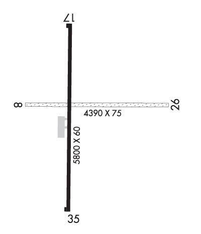
| Lat: N 4011.6 Long: W 11023.0 Elev: 5831 Var: -15 Longest Runway: 5800 | ||
| CTAF: 122.8 | ||
| ||||||||||||||||||||||||||||||||
| ||||||||||||||||||||||||||||||||
| Rwy | Rwy | |||||||
| 3091x75 | 3091' | 3091x75 | 3091' | |||||
| 5800x60 | 5800' | 5800x60 | 5800' | |||||
| Runway ID | Single Wheel | Double Wheel | Double Tandem Wheel | Dual Double Wheel |
| 08/26 | N/A | N/A | N/A | N/A |
| 17/35 | 12,500 | N/A | N/A | N/A |
| These numbers are Advisory and are not limits. The Airport Manager should have more accurate Weight Limits | ||||
 Airport Diagram might not be current. | |
| Facility Name: | DUCHESNE MUNI |
| City Name: | DUCHESNE |
| County: | DUCHESNE |
| State abbrev: | UT |
| State Name: | UTAH |
| Ownership: | PUBLICLY OWNED |
| Use: | OPEN TO THE PUBLIC |
| Owner's Name: | CITY OF DUCHESNE |
| Address: | 500 E MAIN, DRAWER 974 |
| DUCHESNE, UT 84021 | |
| Owner's Phone: | 435-738-2464 |
| Manager's Name: | RODNEY ROWLEY |
| Address: | 500 E MAIN, DRAWER 974 |
| DUCHESNE, UT 84021 | |
| Phone: | 435-823-1292 |
| FAA Region: | NORTHWEST MOUNTAIN |
| FAA Field Office: | DEN |
| Date | Sunrise | Sunset |
|---|---|---|
| 06/08/26 Monday | 5:52 | 20:49 |
| 06/09/26 Tuesday | 5:52 | 20:50 |
| 06/10/26 Wednesday | 5:52 | 20:50 |
| 06/11/26 Thursday | 5:52 | 20:51 |
| 06/12/26 Friday | 5:51 | 20:51 |
| 06/13/26 Saturday | 5:51 | 20:52 |
| 06/14/26 Sunday | 5:51 | 20:52 |
| 06/15/26 Monday | 5:51 | 20:53 |
| 06/16/26 Tuesday | 5:51 | 20:53 |
| 06/17/26 Wednesday | 5:52 | 20:53 |
| 06/18/26 Thursday | 5:52 | 20:54 |
| 06/19/26 Friday | 5:52 | 20:54 |
| 06/20/26 Saturday | 5:52 | 20:54 |
| 06/21/26 Sunday | 5:52 | 20:54 |
| Airport Attendance Schedule | ON CALL |
| Airport Status | OPERATIONAL (This Status can change at any time - please check NOTAMS) |
| Airport Lighting Schedule | ACTVT REIL RWY 17 & 35, PAPI RWY 17 & 35, MIRL RWY 17/35 - CTAF. |
| Airport Storage Available | Tie Downs |
| Extra Services Available | Crop Dusting |
| Wind Indicator | YES - (lighted) |
| Control Tower | NO |
| CTAF Frequency | 122.800 |
| Unicom Frequency | 122.800 |
| Rotating Beacon Color | WG |
| Segmented Circle | YES |
| Landing Fee | NO |
| Airport Inspected | STATE - performed by PRIVATE CONTRACT PERSONNEL |
| Inspection Date | 09/28/2024 |
| Type of Fuel Available | Grade 100LL; -1024 HR SELF SVC. AMERICAN EXPS CREDIT CARD NOT ACPTD. |
| Airframe Repair Service | NONE |
| Power Plant Repair Service | NONE |
| Latitude | N4011.6 |
| Longitude | W11023.0 (ESTIMATED) |
| Arpt Elevation | 5830ft (ESTIMATED) |
| Magnetic Variation | 15E |
| 2 miles NE | of DUCHESNE |
| Traffic Pattern Altitude | |
| Sectional Chart | SALT LAKE CITY |
| Operations (Reported) | Yearly | Avg. Daily |
|---|---|---|
| General Aviation Transient | 0 | 0 |
| General Aviation Local | 0 | 0 |
| Air Taxi | 0 | 0 |
| Commerical | 0 | 0 |
| Commuter | 0 | 0 |
| Military | 0 | 0 |
| Aircraft based on Field | |
|---|---|
| General Aviation Singles | 0 |
| General Aviation Multi | 0 |
| Jet Aircraft | 0 |
| General Aviation Helicopters | 0 |
| Military Aircraft | 0 |
| Gliders | 0 |
| Ultralights | 0 |
| FSS on field | NO |
| FSS tie-in | CEDAR CITY |
| FSS Phone | 1-800-WX-BRIEF |
| Who issues Notams | CDC |
| Notam D service at airport | YES |
| ARTCC Name | SALT LAKE CITY |
| Airport Certification | |
| Aircraft Rescue & Firefighting Index | None |
| Airport of Entry | No |
| Custom Landing Rights | No |
| Joint Civil/Military | No |
| Military Landing rights | No |
| NATIONAL PLAN OF INTEGRATED AIRPORT SYSTEMS (NPIAS) |
| GRANT AGREEMENT HAS EXPIRED; HOWEVER, AGREEMENT REMAINS IN EFFECT FOR THIS FACILITY AS LONG AS IT IS PUBLIC USE. |
| RWY 08/2 6 3000 FT OF USBL RWY LENGTH EAST OF RWY 17/35. |
Airport Communications & Frequencies:
| |||||||||
| Runway: 08 | Runway: 26 | ||
| Mag heading: | 75° | Mag heading: | 255° |
| Rwy Slope: | -.65% Down | Rwy Slope: | .65% Up |
| Approach: | Approach: | ||
| Pattern: | Left Traffic | Pattern: | Left Traffic |
| Markings: | NONE | Markings: | NONE |
| Marking Condition: | POOR | Marking Condition: | POOR |
| Arresting Dev: | Arresting Dev: | ||
| Lat & Long: | N4011.7 W11023.1 | Lat. & Long.: | N4011.7 W11022.4 |
| Elev: | 5819.0 ft. MSL | Elev: | 5798.8 ft. MSL |
| TCH: | TCH: | ||
| Visual Glide Path: | Visual Glide Path: | ||
| Displaced Threshold: | No | Displaced Threshold: | No |
| Touchdown Zone: | YES | Touchdown Zone: | YES |
| Touchdown Elev.: | 5819.7 feet | Touchdown Elev.: | 5819.7 feet |
| Visual Glide Slope: | Visual Glide Slope: | ||
| RVR Equipment: | RVR Equipment: | ||
| RVV Equipment: | NO | RVV Equipment: | NO |
| Approach Lights: | Approach Lights: | ||
| REIL: | NO | REIL: | NO |
| Centerline Lights: | NO | Centerline Lights: | NO |
| Touchdown lights: | NO | Touchdown lights: | NO |
| Runway Category: | Runway with a Visual Approach; 30 FT PLINES & OIL WELLS WEST SIDE RWY 08. | Runway Category: | Runway with a Visual Approach |
| Declared Distances: | Declared Distances: | ||
| Obstructions: | ROAD | Obstructions: | ROAD |
| Marked: | NOT Marked/Lighted | Marked: | NOT Marked/Lighted |
| Clearance slope: | 10 FT PVT RD ACRS APCH. | Clearance slope: | |
| Obstruction height: | 10 feet AGL | Obstruction height: | 10 feet AGL |
| Dist. from runway: | 0 feet | Dist. from runway: | 0 feet |
| Centerline offset: | 125 right of centerline | Centerline offset: | 125 feet right of centerline |
| Comments: | Comments: |
| Runway: 17 | Runway: 35 | ||
| Mag heading: | 165° | Mag heading: | 345° |
| Rwy Slope: | -.64% Down | Rwy Slope: | .64% Up |
| Approach: | Approach: | ||
| Pattern: | Left Traffic | Pattern: | Left Traffic |
| Markings: | NONPRECISION INSTRUMENT | Markings: | NONPRECISION INSTRUMENT |
| Marking Condition: | GOOD | Marking Condition: | GOOD |
| Arresting Dev: | Arresting Dev: | ||
| Lat & Long: | N4012.1 W11023.1 | Lat. & Long.: | N4011.1 W11023.1 |
| Elev: | 5830.9 ft. MSL | Elev: | 5793.5 ft. MSL |
| TCH: | 40 ft. AGL | TCH: | 40 ft. AGL |
| Visual Glide Path: | 3.00 degrees | Visual Glide Path: | 3.00 degrees |
| Displaced Threshold: | No | Displaced Threshold: | No |
| Touchdown Zone: | YES | Touchdown Zone: | YES |
| Touchdown Elev.: | 5830.9 feet | Touchdown Elev.: | 5817.1 feet |
| Visual Glide Slope: | 2-Light PAPI on LEFT side of Runway | Visual Glide Slope: | 2-Light PAPI on LEFT side of Runway |
| RVR Equipment: | RVR Equipment: | ||
| RVV Equipment: | NO | RVV Equipment: | NO |
| Approach Lights: | Approach Lights: | ||
| REIL: | YES | REIL: | YES |
| Centerline Lights: | NO | Centerline Lights: | NO |
| Touchdown lights: | NO | Touchdown lights: | NO |
| Runway Category: | Runway with a Visual Approach | Runway Category: | Runway with a Visual Approach |
| Declared Distances: | Declared Distances: | ||
| Obstructions: | FENCE | Obstructions: | |
| Marked: | NOT Marked/Lighted | Marked: | |
| Clearance slope: | 20:1 | Clearance slope: | 20:1 |
| Obstruction height: | 5 feet AGL | Obstruction height: | |
| Dist. from runway: | 360 feet | Dist. from runway: | |
| Centerline offset: | Centerline offset: | ||
| Comments: | Comments: |
Thanks for using FltPlan.com
all rights reserved © 1999-2026 by Flight Plan LLC
