
| DOWNEY/HYDE MEMORIAL DOWNEY ID |
| |
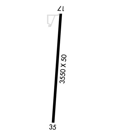
| Lat: N 4225.5 Long: W 11206.6 Elev: 4919 Var: -15 Longest Runway: 3550 | ||
| CTAF: 122.9 | ||
| |||||
|
| Rwy | Rwy | |||||||
| 3550x50 | 3550' | 3550x50 | 3550' | |||||
| Runway ID | Single Wheel | Double Wheel | Double Tandem Wheel | Dual Double Wheel |
| 17/35 | N/A | N/A | N/A | N/A |
| These numbers are Advisory and are not limits. The Airport Manager should have more accurate Weight Limits | ||||
| FltPlan does not have IFR approach charts available for KU58. |
 Airport Diagram might not be current. | |
| Facility Name: | DOWNEY/HYDE MEML/ |
| City Name: | DOWNEY |
| County: | BANNOCK |
| State abbrev: | ID |
| State Name: | IDAHO |
| Ownership: | PUBLICLY OWNED |
| Use: | OPEN TO THE PUBLIC |
| Owner's Name: | CITY OF DOWNEY |
| Address: | PO BOX 204 |
| DOWNEY, ID 83234 | |
| Owner's Phone: | 208-897-5342 |
| Manager's Name: | JOHN HYDE |
| Address: | CITY OF DOWNEY, 15 S. MAIN ST. |
| DOWNEY, ID 83234 | |
| Phone: | 208-851-0348 |
| FAA Region: | NORTHWEST MOUNTAIN |
| FAA Field Office: | HLN |
| Date | Sunrise | Sunset |
|---|---|---|
| 06/08/26 Monday | 5:51 | 21:04 |
| 06/09/26 Tuesday | 5:51 | 21:04 |
| 06/10/26 Wednesday | 5:51 | 21:05 |
| 06/11/26 Thursday | 5:51 | 21:05 |
| 06/12/26 Friday | 5:51 | 21:06 |
| 06/13/26 Saturday | 5:51 | 21:06 |
| 06/14/26 Sunday | 5:51 | 21:07 |
| 06/15/26 Monday | 5:51 | 21:07 |
| 06/16/26 Tuesday | 5:51 | 21:08 |
| 06/17/26 Wednesday | 5:51 | 21:08 |
| 06/18/26 Thursday | 5:51 | 21:08 |
| 06/19/26 Friday | 5:51 | 21:09 |
| 06/20/26 Saturday | 5:51 | 21:09 |
| 06/21/26 Sunday | 5:51 | 21:09 |
| Airport Attendance Schedule | UNATTENDED |
| Airport Status | OPERATIONAL (This Status can change at any time - please check NOTAMS) |
| Airport Lighting Schedule | ACTVT LIRL 17/35 - KEY 122.8 FIVE TIMES.; ACTVT ROTG BCN - KEY 122.8 FIVE TIMES. |
| Airport Storage Available | Tie Downs |
| Extra Services Available | Crop Dusting |
| Wind Indicator | YES - (lighted) |
| Control Tower | NO |
| CTAF Frequency | 122.900 |
| Unicom Frequency | |
| Rotating Beacon Color | WG |
| Segmented Circle | YES |
| Landing Fee | NO |
| Airport Inspected | STATE - performed by STATE AERONAUTICAL PERSONNEL |
| Inspection Date | 03/27/2026 |
| Type of Fuel Available | None |
| Airframe Repair Service | NONE |
| Power Plant Repair Service | NONE |
| Latitude | N4225.5 |
| Longitude | W11206.6 (ESTIMATED) |
| Arpt Elevation | 4919ft (ESTIMATED) |
| Magnetic Variation | 15E |
| 1 miles E | of DOWNEY |
| Traffic Pattern Altitude | |
| Sectional Chart | SALT LAKE CITY |
| Operations (Reported) | Yearly | Avg. Daily |
|---|---|---|
| General Aviation Transient | 0 | 0 |
| General Aviation Local | 0 | 0 |
| Air Taxi | 0 | 0 |
| Commerical | 0 | 0 |
| Commuter | 0 | 0 |
| Military | 0 | 0 |
| Aircraft based on Field | |
|---|---|
| General Aviation Singles | 0 |
| General Aviation Multi | 0 |
| Jet Aircraft | 0 |
| General Aviation Helicopters | 0 |
| Military Aircraft | 0 |
| Gliders | 0 |
| Ultralights | 0 |
| FSS on field | NO |
| FSS tie-in | BOISE |
| FSS Phone | 1-800-WX-BRIEF |
| Who issues Notams | BOI |
| Notam D service at airport | YES |
| ARTCC Name | SALT LAKE CITY |
| Airport Certification | |
| Aircraft Rescue & Firefighting Index | None |
| Airport of Entry | No |
| Custom Landing Rights | No |
| Joint Civil/Military | No |
| Military Landing rights | No |
| FENCES ALL SIDES OF RWY & BTN PARL TO ROAD/RWY. |
| RWY 35 FIRST 900 FT OF RWY IS CURVED 15 DEG TO THE E. |
| FARM MACHINERY TO 20 FT HIGH MAY BE LCTD WITHIN 500 FT OF APCH TO RY 17. |
| RAMP AND TWY ASPH POOR |
| FOR CD CTC SALT LAKE ARTCC AT 801-320-2568. |
| RWY 17/3 5 SOUTH 1000' OF RWY LIGHTS 1'-2' BELOW RWY SURFACE. |
| Runway: 17 | Runway: 35 | ||
| Mag heading: | N/A | Mag heading: | N/A |
| Rwy Slope: | .42% Up | Rwy Slope: | -.42% Down |
| Approach: | Approach: | ||
| Pattern: | Left Traffic | Pattern: | Left Traffic |
| Markings: | NUMBERS ONLY | Markings: | NUMBERS ONLY |
| Marking Condition: | FAIR | Marking Condition: | FAIR |
| Arresting Dev: | Arresting Dev: | ||
| Lat & Long: | N4225.7 W11206.5 | Lat. & Long.: | N4225.2 W11206.6 |
| Elev: | 4904.0 ft. MSL | Elev: | 4919.0 ft. MSL |
| TCH: | TCH: | ||
| Visual Glide Path: | Visual Glide Path: | ||
| Displaced Threshold: | No | Displaced Threshold: | No |
| Touchdown Zone: | NO | Touchdown Zone: | NO |
| Touchdown Elev.: | Touchdown Elev.: | ||
| Visual Glide Slope: | Visual Glide Slope: | ||
| RVR Equipment: | RVR Equipment: | ||
| RVV Equipment: | NO | RVV Equipment: | NO |
| Approach Lights: | Approach Lights: | ||
| REIL: | NO | REIL: | NO |
| Centerline Lights: | NO | Centerline Lights: | NO |
| Touchdown lights: | NO | Touchdown lights: | NO |
| Runway Category: | Runway with a Visual Approach | Runway Category: | Runway with a Visual Approach |
| Declared Distances: | Declared Distances: | ||
| Obstructions: | TANK | Obstructions: | ROAD |
| Marked: | NOT Marked/Lighted | Marked: | NOT Marked/Lighted |
| Clearance slope: | 10:1; 15 FT ROAD PARL TO RWY. | Clearance slope: | |
| Obstruction height: | 25 feet AGL | Obstruction height: | 15 feet AGL |
| Dist. from runway: | 450 feet | Dist. from runway: | 200 feet |
| Centerline offset: | 150 right of centerline | Centerline offset: | 115 feet left of centerline |
| Comments: | RWY 17 +3 FT FENCE 15 FT FM RY END & +3 FT FENCE 45 FT FM RY END; +7 FT PVT ROAD 30 FT FM RY END; +10 BLDG 75 FT R 100 FT FM RY END. | Comments: | RY 35 +15 FT ROAD 0 FT FROM RY END 120 FT L; +2 FT FENCE AT 15 FT ON CNTRLN. |
Thanks for using FltPlan.com
all rights reserved © 1999-2026 by Flight Plan LLC
