
| BEAVER MUNI BEAVER UT |
| |
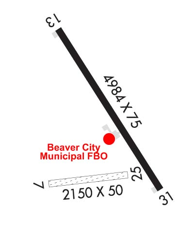
| Lat: N 3813.8 Long: W 11240.5 Elev: 5863 Var: -14 Longest Runway: 4984 | ||
| AWOS: 119.92 CTAF: 122.9 | ||
| |||||||||||||||||||||||||||||||||||||||||||||||||||||||||||||
| |||||||||||||||||||||||||||||||||||||||||||||||||||||||||||||
| |||||||||||||||||||||||||||||||||||||||||||||||||||||||||||||
| Rwy | Rwy | |||||||
| 2150x50 | 2150' | 2150x50 | 2150' | |||||
| 4984x75 | 4984' | 4984x75 | 4984' | |||||
| Runway ID | Single Wheel | Double Wheel | Double Tandem Wheel | Dual Double Wheel |
| 07/25 | N/A | N/A | N/A | N/A |
| 13/31 | 12,500 | N/A | N/A | N/A |
| These numbers are Advisory and are not limits. The Airport Manager should have more accurate Weight Limits | ||||
 Airport Diagram might not be current. | |
| Facility Name: | BEAVER MUNI |
| City Name: | BEAVER |
| County: | BEAVER |
| State abbrev: | UT |
| State Name: | UTAH |
| Ownership: | PUBLICLY OWNED |
| Use: | OPEN TO THE PUBLIC |
| Owner's Name: | BEAVER CITY |
| Address: | PO BOX 271 |
| BEAVER, UT 84713 | |
| Owner's Phone: | 435-438-2451 |
| Manager's Name: | JASON BROWN |
| Address: | 30 WEST 300 NORTH, PO BOX 271 |
| BEAVER, UT 84713 | |
| Phone: | (435) 421-1008 |
| FAA Region: | NORTHWEST MOUNTAIN |
| FAA Field Office: | DEN |
| Date | Sunrise | Sunset |
|---|---|---|
| 09/24/21 Friday | 7:20 | 19:25 |
| 09/25/21 Saturday | 7:21 | 19:23 |
| 09/26/21 Sunday | 7:22 | 19:22 |
| 09/27/21 Monday | 7:23 | 19:20 |
| 09/28/21 Tuesday | 7:24 | 19:19 |
| 09/29/21 Wednesday | 7:24 | 19:17 |
| 09/30/21 Thursday | 7:25 | 19:15 |
| 10/01/21 Friday | 7:26 | 19:14 |
| 10/02/21 Saturday | 7:27 | 19:12 |
| 10/03/21 Sunday | 7:28 | 19:11 |
| 10/04/21 Monday | 7:29 | 19:09 |
| 10/05/21 Tuesday | 7:30 | 19:08 |
| 10/06/21 Wednesday | 7:31 | 19:06 |
| 10/07/21 Thursday | 7:32 | 19:05 |
| Airport Attendance Schedule | UNATTENDED |
| Airport Status | OPERATIONAL (This Status can change at any time - please check NOTAMS) |
| Airport Lighting Schedule | ACTVT REIL RWY 13 & 31; PAPI RWY 13 & 31; MIRL RWY 13/31 - CTAF. |
| Airport Storage Available | Tie Downs |
| Extra Services Available | NONE |
| Wind Indicator | YES - (unlit) |
| Control Tower | NO |
| CTAF Frequency | 122.900 |
| Unicom Frequency | |
| Rotating Beacon Color | CLEAR-GREEN (Light Land Airport) |
| Segmented Circle | YES |
| Landing Fee | NO |
| Airport Inspected | STATE - performed by STATE AERONAUTICAL PERSONNEL |
| Inspection Date | 02/28/2020 |
| Type of Fuel Available | Grade 100LL; -1024 HR FUEL AVBL, SELF SVC CREDIT CARD ADPS. |
| Airframe Repair Service | NONE |
| Power Plant Repair Service | NONE |
| Latitude | N3813.8 |
| Longitude | W11240.5 (ESTIMATED) |
| Arpt Elevation | 5863ft (SURVEYED) |
| Magnetic Variation | 14E |
| 4 miles SW | of BEAVER |
| Traffic Pattern Altitude | |
| Sectional Chart | LAS VEGAS |
| Operations (Reported) | Yearly | Avg. Daily |
|---|---|---|
| General Aviation Transient | 1312 | 4 |
| General Aviation Local | 573 | 2 |
| Air Taxi | 50 | 0 |
| Commerical | 0 | 0 |
| Commuter | 0 | 0 |
| Military | 0 | 0 |
| Aircraft based on Field | |
|---|---|
| General Aviation Singles | 2 |
| General Aviation Multi | 0 |
| Jet Aircraft | 0 |
| General Aviation Helicopters | 0 |
| Military Aircraft | 0 |
| Gliders | 0 |
| Ultralights | 0 |
| FSS on field | NO |
| FSS tie-in | CEDAR CITY |
| FSS Phone | 1-800-WX-BRIEF |
| Who issues Notams | CDC |
| Notam D service at airport | YES |
| ARTCC Name | SALT LAKE CITY |
| Airport Certification | |
| Aircraft Rescue & Firefighting Index | None |
| Airport of Entry | No |
| Custom Landing Rights | No |
| Joint Civil/Military | No |
| Military Landing rights | YES |
| NATIONAL PLAN OF INTEGRATED AIRPORT SYSTEMS (NPIAS) |
| GRANT AGREEMENTS UNDER FAAP/ADAP/AIP |
| CONVEYANCE UNDER SCETION 16, FEDERAL AIRPORT ACT OF 1946 OR SECTION 23, AIRPORT AND AIRWAY DEVELOPMENT ACT OF 1970 |
| ASSURANCES PURSUANT TO TITLE VI, CIVIL RIGHTS ACT OF 1964 |
| CTN - BIRD ACT ON & INVOF ARPT. |
| FOR CD CTC SALT LAKE ARTCC AT 801-320-2568. |
Airport Communications & Frequencies:
| |||||||
| Runway: 07 | Runway: 25 | ||
| Mag heading: | 73° | Mag heading: | 253° |
| Rwy Slope: | .10% Up | Rwy Slope: | -.10% Down |
| Approach: | Approach: | ||
| Pattern: | Left Traffic | Pattern: | Left Traffic |
| Markings: | NONE | Markings: | NONE |
| Marking Condition: | POOR | Marking Condition: | POOR |
| Arresting Dev: | Arresting Dev: | ||
| Lat & Long: | N3813.7 W11240.8 | Lat. & Long.: | N3813.7 W11240.4 |
| Elev: | 5842.3 ft. MSL | Elev: | 5844.5 ft. MSL |
| TCH: | TCH: | ||
| Visual Glide Path: | Visual Glide Path: | ||
| Displaced Threshold: | No | Displaced Threshold: | No |
| Touchdown Zone: | YES | Touchdown Zone: | YES |
| Touchdown Elev.: | 5844.5 feet | Touchdown Elev.: | 5844.5 feet |
| Visual Glide Slope: | Visual Glide Slope: | ||
| RVR Equipment: | RVR Equipment: | ||
| RVV Equipment: | NO | RVV Equipment: | NO |
| Approach Lights: | Approach Lights: | ||
| REIL: | NO | REIL: | NO |
| Centerline Lights: | NO | Centerline Lights: | NO |
| Touchdown lights: | NO | Touchdown lights: | NO |
| Runway Category: | Runway with a Visual Approach | Runway Category: | Runway with a Visual Approach |
| Declared Distances: | Declared Distances: | ||
| Obstructions: | GND | Obstructions: | |
| Marked: | NOT Marked/Lighted; 2 FT DELIMINATORS ACRS RWY 180 FT FM AER 25. | Marked: | |
| Clearance slope: | 27:1 | Clearance slope: | 20:1 |
| Obstruction height: | 7 feet AGL | Obstruction height: | |
| Dist. from runway: | 192 feet | Dist. from runway: | |
| Centerline offset: | Centerline offset: | ||
| Comments: | Comments: |
| Runway: 13 | Runway: 31 | ||
| Mag heading: | 134° | Mag heading: | 314° |
| Rwy Slope: | 1.46% Up | Rwy Slope: | -1.46% Down |
| Approach: | Approach: | ||
| Pattern: | Left Traffic | Pattern: | Left Traffic |
| Markings: | NONPRECISION INSTRUMENT | Markings: | NONPRECISION INSTRUMENT |
| Marking Condition: | GOOD | Marking Condition: | GOOD |
| Arresting Dev: | Arresting Dev: | ||
| Lat & Long: | N3814.3 W11240.8 | Lat. & Long.: | N3813.6 W11240.2 |
| Elev: | 5790.7 ft. MSL | Elev: | 5863.3 ft. MSL |
| TCH: | 40 ft. AGL | TCH: | 59 ft. AGL |
| Visual Glide Path: | 3.00 degrees | Visual Glide Path: | 4.00 degrees |
| Displaced Threshold: | No | Displaced Threshold: | No |
| Touchdown Zone: | YES | Touchdown Zone: | YES |
| Touchdown Elev.: | 5831.4 feet | Touchdown Elev.: | 5863.3 feet |
| Visual Glide Slope: | 2-Light PAPI on LEFT side of Runway | Visual Glide Slope: | 2-Light PAPI on RIGHT side of Runway |
| RVR Equipment: | RVR Equipment: | ||
| RVV Equipment: | NO | RVV Equipment: | NO |
| Approach Lights: | Approach Lights: | ||
| REIL: | YES | REIL: | YES |
| Centerline Lights: | NO | Centerline Lights: | NO |
| Touchdown lights: | NO | Touchdown lights: | NO |
| Runway Category: | Runway with a Non-precision Approach | Runway Category: | Runway with a Non-precision Approach |
| Declared Distances: | Declared Distances: |
Thanks for using FltPlan.com
all rights reserved © 1999-2021 by Flight Plan LLC
