
| STANFORD FIELD ST ANTHONY ID |
| |
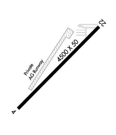
| Lat: N 4357.0 Long: W 11141.1 Elev: 4966 Var: -16 Longest Runway: 4500 | ||
| CTAF: 122.9 | ||
| ||||||
|
| Rwy | Rwy | |||||||
| 4500x50 | 4200' | 4500x50 | 3960' | |||||
| Runway ID | Single Wheel | Double Wheel | Double Tandem Wheel | Dual Double Wheel |
| 04/22 | N/A | N/A | N/A | N/A |
| These numbers are Advisory and are not limits. The Airport Manager should have more accurate Weight Limits | ||||
| FltPlan does not have IFR approach charts available for KU12. |
 Airport Diagram might not be current. | |
| Facility Name: | STANFORD FLD |
| City Name: | ST ANTHONY |
| County: | FREMONT |
| State abbrev: | ID |
| State Name: | IDAHO |
| Ownership: | PUBLICLY OWNED |
| Use: | OPEN TO THE PUBLIC |
| Owner's Name: | CITY OF ST. ANTHONY |
| Address: | 110 W MAIN ST |
| ST ANTHONY, ID 83445 | |
| Owner's Phone: | 208-624-3494 |
| Manager's Name: | DIRK FORBUSH |
| Address: | 110 W MAIN |
| ST. ANTHONY, ID 83445 | |
| Phone: | 208-313-6594 |
| FAA Region: | NORTHWEST MOUNTAIN |
| FAA Field Office: | HLN |
| Date | Sunrise | Sunset |
|---|---|---|
| 09/24/21 Friday | 7:16 | 19:21 |
| 09/25/21 Saturday | 7:17 | 19:19 |
| 09/26/21 Sunday | 7:18 | 19:17 |
| 09/27/21 Monday | 7:19 | 19:15 |
| 09/28/21 Tuesday | 7:21 | 19:13 |
| 09/29/21 Wednesday | 7:22 | 19:12 |
| 09/30/21 Thursday | 7:23 | 19:10 |
| 10/01/21 Friday | 7:24 | 19:08 |
| 10/02/21 Saturday | 7:25 | 19:06 |
| 10/03/21 Sunday | 7:27 | 19:04 |
| 10/04/21 Monday | 7:28 | 19:02 |
| 10/05/21 Tuesday | 7:29 | 19:01 |
| 10/06/21 Wednesday | 7:30 | 18:59 |
| 10/07/21 Thursday | 7:31 | 18:57 |
| Airport Attendance Schedule | UNATTENDED; UNATNDD |
| Airport Status | OPERATIONAL (This Status can change at any time - please check NOTAMS) |
| Airport Lighting Schedule | ACTVT MIRL RY 04/22 - CTAF.; ACTVT BCN - CTAF. |
| Airport Storage Available | Tie Downs |
| Extra Services Available | Crop Dusting |
| Wind Indicator | YES - (lighted) |
| Control Tower | NO |
| CTAF Frequency | 122.900 |
| Unicom Frequency | |
| Rotating Beacon Color | CLEAR-GREEN (Light Land Airport) |
| Segmented Circle | YES; SEGMENTED CRC IS NSTD - PAINTED TIRES. |
| Landing Fee | NO |
| Airport Inspected | STATE - performed by STATE AERONAUTICAL PERSONNEL |
| Inspection Date | 10/30/2020 |
| Type of Fuel Available | Grade 100LL, JET A (freeze point -40C); -10FUEL 24 HR CREDIT CARD SVC AVBL. |
| Airframe Repair Service | NONE |
| Power Plant Repair Service | NONE |
| Latitude | N4357.0 |
| Longitude | W11141.1 (ESTIMATED) |
| Arpt Elevation | 4966ft (SURVEYED) |
| Magnetic Variation | 16E |
| 1 miles SE | of ST ANTHONY |
| Traffic Pattern Altitude | 800 |
| Sectional Chart | SALT LAKE CITY |
| Operations (Reported) | Yearly | Avg. Daily |
|---|---|---|
| General Aviation Transient | 3250 | 9 |
| General Aviation Local | 1550 | 4 |
| Air Taxi | 90 | 0 |
| Commerical | 0 | 0 |
| Commuter | 0 | 0 |
| Military | 20 | 0 |
| Aircraft based on Field | |
|---|---|
| General Aviation Singles | 24 |
| General Aviation Multi | 0 |
| Jet Aircraft | 0 |
| General Aviation Helicopters | 1 |
| Military Aircraft | 0 |
| Gliders | 0 |
| Ultralights | 5 |
| FSS on field | NO |
| FSS tie-in | BOISE |
| FSS Phone | 1-800-WX-BRIEF |
| Who issues Notams | BOI |
| Notam D service at airport | YES |
| ARTCC Name | SALT LAKE CITY |
| Airport Certification | |
| Aircraft Rescue & Firefighting Index | None |
| Airport of Entry | No |
| Custom Landing Rights | No |
| Joint Civil/Military | No |
| Military Landing rights | No |
| ACFT OPER FROM GRAVEL RWY SE OF PAVED RWY DURING AGRI SEASON. |
| FOR CD CTC SALT LAKE ARTCC AT 801-320-2568. |
| Runway: 04 | Runway: 22 | ||
| Mag heading: | N/A | Mag heading: | N/A |
| Approach: | Approach: | ||
| Pattern: | Left Traffic | Pattern: | Left Traffic |
| Markings: | NONSTANDARD | Markings: | NONSTANDARD |
| Marking Condition: | FAIR; RWY 04 RY 04/22 NO DSPLCD THLD ARROW MARKINGS ON DSPLCD THLD. | Marking Condition: | FAIR |
| Arresting Dev: | Arresting Dev: | ||
| Lat & Long: | N4356.8 W11141.5 | Lat. & Long.: | N4357.3 W11140.7 |
| Elev: | N/A | Elev: | N/A |
| TCH: | TCH: | ||
| Visual Glide Path: | Visual Glide Path: | ||
| Displaced Threshold: | 300 feet; 04/22 DSPLCD THRS MKD BY DSPLCD THR LGTS ONLY. | Displaced Threshold: | 540 feet |
| Touchdown Zone: | NO | Touchdown Zone: | NO |
| Touchdown Elev.: | Touchdown Elev.: | ||
| Visual Glide Slope: | Visual Glide Slope: | ||
| RVR Equipment: | RVR Equipment: | ||
| RVV Equipment: | NO | RVV Equipment: | NO |
| Approach Lights: | Approach Lights: | ||
| REIL: | NO | REIL: | NO |
| Centerline Lights: | NO | Centerline Lights: | NO |
| Touchdown lights: | NO | Touchdown lights: | NO |
| Runway Category: | Runway with a Visual Approach | Runway Category: | Runway with a Visual Approach |
| Declared Distances: | Declared Distances: | ||
| Obstructions: | PLINE | Obstructions: | TREE; NMRS ADDNL OBSTNS AT 200 FT INCL FENCES, BLDGS, TREES, ROADS, ETC. |
| Marked: | NOT Marked/Lighted | Marked: | NOT Marked/Lighted |
| Clearance slope: | 18:1; 25:1 TO DSPLCD THR. | Clearance slope: | 1:1; 21:1 TO DSPLCD THLD. |
| Obstruction height: | 70 feet AGL | Obstruction height: | 55 feet AGL |
| Dist. from runway: | 1500 feet | Dist. from runway: | 300 feet |
| Centerline offset: | Centerline offset: | 40 feet left of centerline | |
| Comments: | +5 FT FENCE AT 0 FT; 50 FT L. +8' BERM AT 0', 70' L. | Comments: | NMRS CLOSE-IN OBSTS (TREES & STRUCTURES) LCTD IN PRI SFC. |
Thanks for using FltPlan.com
all rights reserved © 1999-2021 by Flight Plan LLC
