
| BULLFROG BASIN GLEN CANYON NATL REC UT |
| |
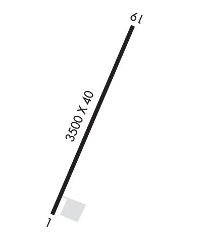
| Lat: N 3732.7 Long: W 11042.8 Elev: 4167 Var: -13 Longest Runway: 3500 | ||
| CTAF: 122.8 | ||
| ||||||||||||||||||||||||||||||||
| ||||||||||||||||||||||||||||||||
| Rwy | Rwy | |||||||
| 3500x40 | 3500' | 3500x40 | 3500' | |||||
| Runway ID | Single Wheel | Double Wheel | Double Tandem Wheel | Dual Double Wheel |
| 01/19 | 12,500 | N/A | N/A | N/A |
| These numbers are Advisory and are not limits. The Airport Manager should have more accurate Weight Limits | ||||
| FltPlan does not have IFR approach charts available for KU07. |
 Airport Diagram might not be current. | |
| Facility Name: | BULLFROG BASIN |
| City Name: | GLEN CANYON NATL REC AREA |
| County: | KANE |
| State abbrev: | UT |
| State Name: | UTAH |
| Ownership: | PUBLICLY OWNED |
| Use: | OPEN TO THE PUBLIC |
| Owner's Name: | US NATIONAL PARK SVC |
| Address: | PO BOX 1507 |
| PAGE, AZ 86040 | |
| Owner's Phone: | 928-608-6253 |
| Manager's Name: | GLEN CANYON DISPATCH |
| Address: | P.O BOX 1507 |
| PAGE, AZ 86040 | |
| Phone: | 928-608-6401 |
| FAA Region: | NORTHWEST MOUNTAIN |
| FAA Field Office: | DEN |
| Date | Sunrise | Sunset |
|---|---|---|
| 09/24/21 Friday | 7:12 | 19:17 |
| 09/25/21 Saturday | 7:13 | 19:15 |
| 09/26/21 Sunday | 7:14 | 19:14 |
| 09/27/21 Monday | 7:15 | 19:12 |
| 09/28/21 Tuesday | 7:16 | 19:11 |
| 09/29/21 Wednesday | 7:16 | 19:09 |
| 09/30/21 Thursday | 7:17 | 19:08 |
| 10/01/21 Friday | 7:18 | 19:06 |
| 10/02/21 Saturday | 7:19 | 19:05 |
| 10/03/21 Sunday | 7:20 | 19:03 |
| 10/04/21 Monday | 7:21 | 19:02 |
| 10/05/21 Tuesday | 7:22 | 19:00 |
| 10/06/21 Wednesday | 7:23 | 18:59 |
| 10/07/21 Thursday | 7:24 | 18:57 |
| Airport Attendance Schedule | UNATTENDED |
| Airport Status | OPERATIONAL (This Status can change at any time - please check NOTAMS) |
| Airport Lighting Schedule | NATIONAL PARK SERVICE USE ONLY. |
| Airport Storage Available | Tie Downs |
| Extra Services Available | NONE |
| Wind Indicator | YES - (unlit) |
| Control Tower | NO |
| CTAF Frequency | 122.800 |
| Unicom Frequency | 122.800; UNICOM MONITORED 0700-1900, AT MARINA. |
| Rotating Beacon Color | |
| Segmented Circle | YES; MKD WITH WHITE TIRES. |
| Landing Fee | NO |
| Airport Inspected | STATE - performed by STATE AERONAUTICAL PERSONNEL |
| Inspection Date | 06/04/2019 |
| Type of Fuel Available | None |
| Airframe Repair Service | NONE |
| Power Plant Repair Service | NONE |
| Latitude | N3732.7 |
| Longitude | W11042.8 (ESTIMATED) |
| Arpt Elevation | 4167ft (ESTIMATED) |
| Magnetic Variation | 13E |
| 5 miles N; 5 NM N OF BULLFROG MARINA. | of GLEN CANYON NATL REC AREA |
| Traffic Pattern Altitude | |
| Sectional Chart | DENVER |
| Operations (Reported) | Yearly | Avg. Daily |
|---|---|---|
| General Aviation Transient | 1596 | 4 |
| General Aviation Local | 876 | 2 |
| Air Taxi | 30 | 0 |
| Commerical | 0 | 0 |
| Commuter | 0 | 0 |
| Military | 0 | 0 |
| Aircraft based on Field | |
|---|---|
| General Aviation Singles | 0 |
| General Aviation Multi | 0 |
| Jet Aircraft | 0 |
| General Aviation Helicopters | 0 |
| Military Aircraft | 0 |
| Gliders | 0 |
| Ultralights | 0 |
| FSS on field | NO |
| FSS tie-in | CEDAR CITY |
| FSS Phone | 1-800-WX-BRIEF |
| Who issues Notams | CDC |
| Notam D service at airport | YES |
| ARTCC Name | DENVER |
| Airport Certification | |
| Aircraft Rescue & Firefighting Index | None |
| Airport of Entry | No |
| Custom Landing Rights | No |
| Joint Civil/Military | No |
| Military Landing rights | YES |
| HILL 800' SW OF S END RWY. |
| BOTH ENDS OF RWY HIGHER THAN CTR. |
| NATIONAL PARK SERVICE ACFT FREQUENTLY USE NSTD TFC PATTERN - MONITOR CTAF. |
| FOR CD IF UNA TO CTC ON FSS FREQ, CTC DENVER ARTCC AT 303-651-4257. |
| Runway: 01 | Runway: 19 | ||
| Mag heading: | N/A | Mag heading: | N/A |
| Approach: | Approach: | ||
| Pattern: | Left Traffic | Pattern: | Left Traffic |
| Markings: | NONSTANDARD | Markings: | NONSTANDARD |
| Marking Condition: | GOOD; RWY 01 & 19 STD VIS MKGS; NO DISPLACED THLD MARKED. | Marking Condition: | GOOD; NSTD LINE WIDTHS ON CENTERLINE, NUMBERS & DSPLCD THLD. |
| Arresting Dev: | Arresting Dev: | ||
| Lat & Long: | Lat. & Long.: | ||
| Elev: | N/A | Elev: | N/A |
| TCH: | TCH: | ||
| Visual Glide Path: | Visual Glide Path: | ||
| Displaced Threshold: | No | Displaced Threshold: | No |
| Touchdown Zone: | NO | Touchdown Zone: | NO |
| Touchdown Elev.: | Touchdown Elev.: | ||
| Visual Glide Slope: | Visual Glide Slope: | ||
| RVR Equipment: | RVR Equipment: | ||
| RVV Equipment: | NO | RVV Equipment: | NO |
| Approach Lights: | Approach Lights: | ||
| REIL: | NO | REIL: | NO |
| Centerline Lights: | NO | Centerline Lights: | NO |
| Touchdown lights: | NO | Touchdown lights: | NO |
| Runway Category: | Runway with a Visual Approach | Runway Category: | Runway with a Visual Approach |
| Declared Distances: | Declared Distances: | ||
| Obstructions: | HILL | Obstructions: | HILL |
| Marked: | NOT Marked/Lighted | Marked: | NOT Marked/Lighted |
| Clearance slope: | 10:1; RWY 01 APCH SLOPE 10:1 TO RWY EDGE. | Clearance slope: | 17:1; RWY 19 APCH SLOPE 17:1 TO RWY EDGE. |
| Obstruction height: | 60 feet AGL | Obstruction height: | 30 feet AGL |
| Dist. from runway: | 870 feet; 60 FT PLUS HILL, 60 FT ON CNTRLN EXTENDED. | Dist. from runway: | 720 feet; +30' HILL ON CNTRLN EXTDD. |
| Centerline offset: | Centerline offset: | ||
| Comments: | Comments: |
Thanks for using FltPlan.com
all rights reserved © 1999-2021 by Flight Plan LLC
