
| BUHL MUNI BUHL ID |
| |
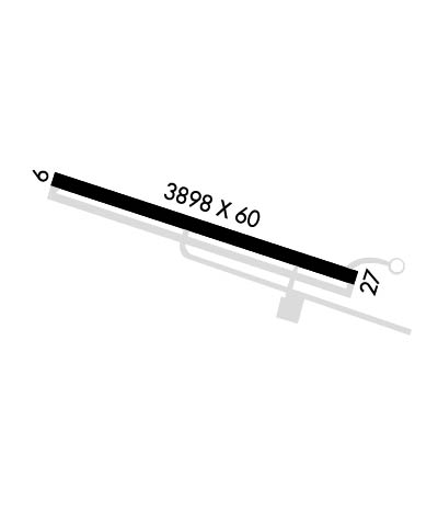
| Lat: N 4235.8 Long: W 11448.0 Elev: 3663 Var: -16 Longest Runway: 3898 | ||
| CTAF: 122.9 | ||
| ||||||
|
| Rwy | Rwy | |||||||
| 3898x60 | 3898' | 3898x60 | 3898' | |||||
| Runway ID | Single Wheel | Double Wheel | Double Tandem Wheel | Dual Double Wheel |
| 09/27 | 12,500 | N/A | N/A | N/A |
| These numbers are Advisory and are not limits. The Airport Manager should have more accurate Weight Limits | ||||
| FltPlan does not have IFR approach charts available for KU03. |
 Airport Diagram might not be current. | |
| Facility Name: | BUHL MUNI |
| City Name: | BUHL |
| County: | TWIN FALLS |
| State abbrev: | ID |
| State Name: | IDAHO |
| Ownership: | PUBLICLY OWNED |
| Use: | OPEN TO THE PUBLIC |
| Owner's Name: | CITY OF BUHL |
| Address: | 203 BROADWAY NORTH |
| BUHL, ID 83316 | |
| Owner's Phone: | 208-543-5650 |
| Manager's Name: | NEIL RING |
| Address: | 203 BROADWAY NORTH |
| BUHL, ID 83316 | |
| Phone: | 208-961-6539 |
| FAA Region: | NORTHWEST MOUNTAIN |
| FAA Field Office: | HLN |
| Date | Sunrise | Sunset |
|---|---|---|
| 06/08/26 Monday | 6:02 | 21:15 |
| 06/09/26 Tuesday | 6:01 | 21:16 |
| 06/10/26 Wednesday | 6:01 | 21:16 |
| 06/11/26 Thursday | 6:01 | 21:17 |
| 06/12/26 Friday | 6:01 | 21:17 |
| 06/13/26 Saturday | 6:01 | 21:18 |
| 06/14/26 Sunday | 6:01 | 21:18 |
| 06/15/26 Monday | 6:01 | 21:19 |
| 06/16/26 Tuesday | 6:01 | 21:19 |
| 06/17/26 Wednesday | 6:01 | 21:19 |
| 06/18/26 Thursday | 6:01 | 21:20 |
| 06/19/26 Friday | 6:01 | 21:20 |
| 06/20/26 Saturday | 6:01 | 21:20 |
| 06/21/26 Sunday | 6:01 | 21:20 |
| Airport Attendance Schedule | 7 Days A Week 0830-1700; PHONE 208-731-3781 FOR SVC WHEN ARPT UNATTENDED. |
| Airport Status | OPERATIONAL (This Status can change at any time - please check NOTAMS) |
| Airport Lighting Schedule | ACTVT MIRL RY 09/27 - CTAF. |
| Airport Storage Available | Tie Downs |
| Extra Services Available | Crop Dusting, Flight Instruction, Aircraft Rental |
| Wind Indicator | YES - (lighted) |
| Control Tower | NO |
| CTAF Frequency | 122.900 |
| Unicom Frequency | |
| Rotating Beacon Color | WG |
| Segmented Circle | YES |
| Landing Fee | NO |
| Airport Inspected | FEDERAL - performed by STATE AERONAUTICAL PERSONNEL |
| Inspection Date | 02/12/2026 |
| Type of Fuel Available | Grade 100LLMOGAS |
| Airframe Repair Service | MAJOR |
| Power Plant Repair Service | MAJOR |
| Latitude | N4235.8 |
| Longitude | W11448.0 (ESTIMATED) |
| Arpt Elevation | 3662ft (SURVEYED) |
| Magnetic Variation | 16E |
| 2 miles W | of BUHL |
| Traffic Pattern Altitude | |
| Sectional Chart | SALT LAKE CITY |
| Operations (Reported) | Yearly | Avg. Daily |
|---|---|---|
| General Aviation Transient | 0 | 0 |
| General Aviation Local | 0 | 0 |
| Air Taxi | 0 | 0 |
| Commerical | 0 | 0 |
| Commuter | 0 | 0 |
| Military | 0 | 0 |
| Aircraft based on Field | |
|---|---|
| General Aviation Singles | 0 |
| General Aviation Multi | 0 |
| Jet Aircraft | 0 |
| General Aviation Helicopters | 0 |
| Military Aircraft | 0 |
| Gliders | 0 |
| Ultralights | 0 |
| FSS on field | NO |
| FSS tie-in | BOISE |
| FSS Phone | 1-800-WX-BRIEF |
| Who issues Notams | BOI |
| Notam D service at airport | YES |
| ARTCC Name | SALT LAKE CITY |
| Airport Certification | |
| Aircraft Rescue & Firefighting Index | None |
| Airport of Entry | No |
| Custom Landing Rights | No |
| Joint Civil/Military | No |
| Military Landing rights | YES |
| NATIONAL PLAN OF INTEGRATED AIRPORT SYSTEMS (NPIAS) |
| GRANT AGREEMENTS UNDER FAAP/ADAP/AIP |
| ASSURANCES PURSUANT TO TITLE VI, CIVIL RIGHTS ACT OF 1964 |
| NO LIGHTS, ONLY REFLECTORS ON PARL TWY. |
| FOR CD CTC TWIN FALLS APCH AT 208-734-7160, WHEN APCH CLSD CTC SALT LAKE ARTCC AT 801-320-2568. |
| RWY 27 +15 FT DIRT PILES, HEAVY EQPT AND SEMI TRAILERS PARKED AT 900 FT ON CNTRLN. |
| CTN: FOR CLOSE-IN/SHORT FINAL OPS FOR RWY 27, BE AWARE OF 20 FT PWR POLE AT 525 FT, 150 FT RT. |
| Runway: 09 | Runway: 27 | ||
| Mag heading: | 93° | Mag heading: | 273° |
| Rwy Slope: | 1.38% Up | Rwy Slope: | -1.38% Down |
| Approach: | Approach: | ||
| Pattern: | Left Traffic | Pattern: | Left Traffic |
| Markings: | BASIC | Markings: | BASIC |
| Marking Condition: | GOOD | Marking Condition: | GOOD |
| Arresting Dev: | Arresting Dev: | ||
| Lat & Long: | N4235.9 W11448.4 | Lat. & Long.: | N4235.7 W11447.6 |
| Elev: | 3608.8 ft. MSL | Elev: | 3662.7 ft. MSL |
| TCH: | TCH: | ||
| Visual Glide Path: | Visual Glide Path: | ||
| Displaced Threshold: | No | Displaced Threshold: | No |
| Touchdown Zone: | YES | Touchdown Zone: | YES |
| Touchdown Elev.: | 3651.0 feet | Touchdown Elev.: | 3662.7 feet |
| Visual Glide Slope: | Visual Glide Slope: | ||
| RVR Equipment: | RVR Equipment: | ||
| RVV Equipment: | NO | RVV Equipment: | NO |
| Approach Lights: | Approach Lights: | ||
| REIL: | NO | REIL: | NO |
| Centerline Lights: | NO | Centerline Lights: | NO |
| Touchdown lights: | NO | Touchdown lights: | NO |
| Runway Category: | Runway with a Visual Approach | Runway Category: | Runway with a Visual Approach |
| Declared Distances: | Declared Distances: | ||
| Obstructions: | FENCE; 20 FT PWR POLE, 525 FT FM RWY END, 150 FT R; 16:1. | Obstructions: | ROAD |
| Marked: | NOT Marked/Lighted | Marked: | NOT Marked/Lighted |
| Clearance slope: | 20:1; 5 FT BARB WIRE FENCE AT 100 FT ON CNTRLN. | Clearance slope: | 21:1 |
| Obstruction height: | 5 feet AGL | Obstruction height: | 15 feet AGL |
| Dist. from runway: | 300 feet | Dist. from runway: | 525 feet |
| Centerline offset: | Centerline offset: | ||
| Comments: | Comments: |
Thanks for using FltPlan.com
all rights reserved © 1999-2026 by Flight Plan LLC
