
| TEXARKANA RGNL-WEBB FIELD TEXARKANA AR |
| |
| Lat: N 3327.2 Long: W 09359.5 Elev: 390 Var: -05 Longest Runway: 6601 | ||
| Dept. ATIS: 120.2 Arr. ATIS: 120.2 Ground: 119.22 Tower: 123.87 | ||
| |||||||||||||||||||||||||||||||||||||||||||||||||||||||||||||||||||||
| |||||||||||||||||||||||||||||||||||||||||||||||||||||||||||||||||||||
| |||||||||||||||||||||||||||||||||||||||||||||||||||||||||||||||||||||
| Rwy | Rwy | |||||||
| 6601x150 | 6601' | 6601x150 | 6601' | 111.90 - 219° | ||||
| 5200x100 | 4559' | 5200x100 | 5200' | |||||
| Runway ID | Single Wheel | Double Wheel | Double Tandem Wheel | Dual Double Wheel |
| 04/22 | 50,000 | 86,000 | 120,000 | N/A |
| 13/31 | 25,000 | N/A | N/A | N/A |
| These numbers are Advisory and are not limits. The Airport Manager should have more accurate Weight Limits | ||||
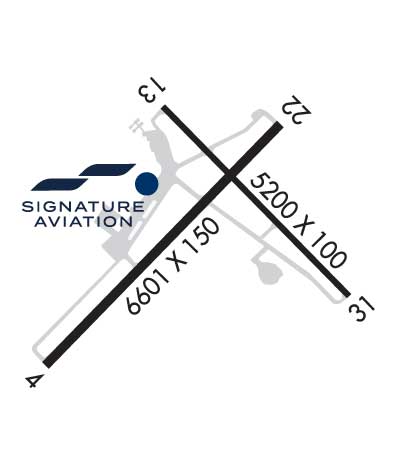 Airport Diagram might not be current. | |
| Facility Name: | TEXARKANA RGNL-WEBB FLD |
| City Name: | TEXARKANA |
| County: | MILLER |
| State abbrev: | AR |
| State Name: | ARKANSAS |
| Ownership: | PUBLICLY OWNED |
| Use: | OPEN TO THE PUBLIC |
| Owner's Name: | TEXARKANA AIRPORT AUTHORITY; FERDINAND MEHRLICH |
| Address: | 201 AIRPORT DR |
| TEXARKANA, AR 71854 | |
| Owner's Phone: | 870-774-2171 |
| Manager's Name: | FERDINAND PAUL MEHRLICH III, CM ACE |
| Address: | 201 AIRPORT DR |
| TEXARKANA, AR 71854 | |
| Phone: | 870-774-2171 |
| FAA Region: | SOUTHWEST |
| FAA Field Office: | AOK |
| Date | Sunrise | Sunset |
|---|---|---|
| 09/24/21 Friday | 7:05 | 19:10 |
| 09/25/21 Saturday | 7:06 | 19:09 |
| 09/26/21 Sunday | 7:07 | 19:07 |
| 09/27/21 Monday | 7:07 | 19:06 |
| 09/28/21 Tuesday | 7:08 | 19:05 |
| 09/29/21 Wednesday | 7:09 | 19:03 |
| 09/30/21 Thursday | 7:09 | 19:02 |
| 10/01/21 Friday | 7:10 | 19:01 |
| 10/02/21 Saturday | 7:11 | 18:59 |
| 10/03/21 Sunday | 7:12 | 18:58 |
| 10/04/21 Monday | 7:12 | 18:57 |
| 10/05/21 Tuesday | 7:13 | 18:55 |
| 10/06/21 Wednesday | 7:14 | 18:54 |
| 10/07/21 Thursday | 7:14 | 18:53 |
| Airport Attendance Schedule | 7 Days A Week 0600-2200 |
| Airport Status | OPERATIONAL (This Status can change at any time - please check NOTAMS) |
| Airport Lighting Schedule | WHEN ATCT CLSD ACTVT MALSR RWY 22; HIRL RWY 04/22; MIRL RWY 13/31 - CTAF. |
| Airport Storage Available | Tie Downs, Hanger |
| Extra Services Available | Air Freight, Charter, Flight Instruction, Aircraft Rental, Aircraft Sales |
| Wind Indicator | YES - (lighted) |
| Control Tower | YES |
| CTAF Frequency | 123.875 |
| Unicom Frequency | |
| Rotating Beacon Color | CLEAR-GREEN (Light Land Airport) |
| Segmented Circle | YES |
| Landing Fee | YES |
| Airport Inspected | FEDERAL - performed by FAA AIRPORTS FIELD PERSONNEL |
| Inspection Date | 09/22/2020 |
| Type of Fuel Available | Grade 100LL, JET A (freeze point -40C) |
| Airframe Repair Service | MAJOR |
| Power Plant Repair Service | MAJOR |
| Latitude | N3327.2 |
| Longitude | W09359.5 (ESTIMATED) |
| Arpt Elevation | 389ft (SURVEYED) |
| Magnetic Variation | 05E |
| 3 miles NE | of TEXARKANA |
| Traffic Pattern Altitude | 1200 |
| Sectional Chart | MEMPHIS |
| Operations (Reported) | Yearly | Avg. Daily |
|---|---|---|
| General Aviation Transient | 11317 | 31 |
| General Aviation Local | 14006 | 38 |
| Air Taxi | 4978 | 14 |
| Commerical | 21 | 0 |
| Commuter | 0 | 0 |
| Military | 2276 | 6 |
| Aircraft based on Field | |
|---|---|
| General Aviation Singles | 31 |
| General Aviation Multi | 7 |
| Jet Aircraft | 10 |
| General Aviation Helicopters | 4 |
| Military Aircraft | 0 |
| Gliders | 0 |
| Ultralights | 0 |
| FSS on field | NO |
| FSS tie-in | JONESBORO |
| FSS Phone | 1-800-WX-BRIEF |
| Who issues Notams | TXK |
| Notam D service at airport | YES |
| ARTCC Name | FORT WORTH |
| Airport Certification | AIRPORT RECEIVING SCHEDULED AIR CARRIER SERVICE FROM CARRIERS CERTIFICATED BY THE CIVIL AERONAUTICS BOARD |
| Aircraft Rescue & Firefighting Index | AIRPORT HAS A CERTIFICATE UNDER CFR PART 139 |
| Airport of Entry | No |
| Custom Landing Rights | No |
| Joint Civil/Military | No |
| Military Landing rights | YES |
| NATIONAL PLAN OF INTEGRATED AIRPORT SYSTEMS (NPIAS) |
| GRANT AGREEMENTS UNDER FAAP/ADAP/AIP |
| SURPLUS PROPERTY AGREEMENT UNDER PUBLIC LAW 289 |
| OBLIGATIONS ASSUMED BY TRANSFER |
| ASSURANCES PURSUANT TO TITLE VI, CIVIL RIGHTS ACT OF 1964 |
| AGREEMENT UNDER DLAND OR DCLA HAS EXPIRED. |
| THIS AIRPORT HAS BEEN SURVEYED BY THE NATIONAL GEODETIC SURVEY. |
| DEER ON & INVOF ARPT. |
| FOR CD IF UNA TO CTC ON FSS FREQ, CTC FORT WORTH ARTCC AT 817-858-7584. |
Airport Communications & Frequencies:
| |||||||||||||||||||
| Runway: 04 | Runway: 22 | ||
| Mag heading: | 40° | Mag heading: | 220° |
| Rwy Slope: | .70% Up | Rwy Slope: | -.70% Down |
| Approach: | Approach: | ILS/DME | |
| Pattern: | Left Traffic | Pattern: | Left Traffic |
| Markings: | PRECISION INSTRUMENT | Markings: | PRECISION INSTRUMENT |
| Marking Condition: | GOOD | Marking Condition: | GOOD |
| Arresting Dev: | Arresting Dev: | ||
| Lat & Long: | N3326.8 W09400.1 | Lat. & Long.: | N3327.5 W09359.2 |
| Elev: | 338.1 ft. MSL | Elev: | 384.3 ft. MSL |
| TCH: | 52 ft. AGL | TCH: | |
| Visual Glide Path: | 3.00 degrees | Visual Glide Path: | |
| Displaced Threshold: | No | Displaced Threshold: | No |
| Touchdown Zone: | YES | Touchdown Zone: | YES |
| Touchdown Elev.: | 359.8 feet | Touchdown Elev.: | 384.3 feet |
| Visual Glide Slope: | 4-BOX VASI ON LEFT SIDE OF RUNWAY | Visual Glide Slope: | |
| RVR Equipment: | RVR Equipment: | ||
| RVV Equipment: | NO | RVV Equipment: | NO |
| Approach Lights: | Approach Lights: | MALSR - 1,400 foot medium intensity approach lighting system with runway alignment indicator lights | |
| REIL: | NO | REIL: | NO |
| Centerline Lights: | NO | Centerline Lights: | NO |
| Touchdown lights: | NO | Touchdown lights: | NO |
| Runway Category: | Runway with a Non-precision Approach having visibility minimums greater than 3/4 mile | Runway Category: | Precision Instrument Runway |
| Declared Distances: | TORA:6601' TODA:6601' ASDA:6601' LDA:6601' | Declared Distances: | TORA:6601' TODA:6601' ASDA:6601' LDA:6601' |
| Obstructions: | TREES | Obstructions: | TREES |
| Marked: | NOT Marked/Lighted | Marked: | NOT Marked/Lighted |
| Clearance slope: | 2:1 | Clearance slope: | 9:1 |
| Obstruction height: | 31 feet AGL | Obstruction height: | 17 feet AGL |
| Dist. from runway: | 263 feet | Dist. from runway: | 358 feet |
| Centerline offset: | 505 left of centerline | Centerline offset: | 511 feet left of centerline |
| Comments: | Comments: |
| Runway: 13 | Runway: 31 | ||
| Mag heading: | 130° | Mag heading: | 310° |
| Rwy Slope: | .48% Up | Rwy Slope: | -.48% Down |
| Approach: | Approach: | ||
| Pattern: | Left Traffic | Pattern: | Left Traffic |
| Markings: | NONPRECISION INSTRUMENT | Markings: | NONPRECISION INSTRUMENT |
| Marking Condition: | GOOD | Marking Condition: | GOOD |
| Arresting Dev: | Arresting Dev: | ||
| Lat & Long: | N3327.6 W09359.6 | Lat. & Long.: | N3327.0 W09358.9 |
| Elev: | 360.8 ft. MSL | Elev: | 385.8 ft. MSL |
| TCH: | 54 ft. AGL | TCH: | 39 ft. AGL |
| Visual Glide Path: | 3.00 degrees | Visual Glide Path: | 3.00 degrees |
| Displaced Threshold: | 641 feet | Displaced Threshold: | No |
| Touchdown Zone: | YES | Touchdown Zone: | YES |
| Touchdown Elev.: | 386.7 feet | Touchdown Elev.: | 389.5 feet |
| Visual Glide Slope: | 4-Light PAPI on LEFT side of Runway | Visual Glide Slope: | 4-Light PAPI on LEFT side of Runway |
| RVR Equipment: | RVR Equipment: | ||
| RVV Equipment: | NO | RVV Equipment: | NO |
| Approach Lights: | Approach Lights: | ||
| REIL: | NO | REIL: | NO |
| Centerline Lights: | NO | Centerline Lights: | NO |
| Touchdown lights: | NO | Touchdown lights: | NO |
| Runway Category: | Runway with a Non-precision Approach having visibility minimums greater than 3/4 mile | Runway Category: | Runway with a Non-precision Approach having visibility minimums greater than 3/4 mile |
| Declared Distances: | TORA:5200' TODA:5200' ASDA:5200' LDA:4559' | Declared Distances: | TORA:5200' TODA:5200' ASDA:4559' LDA:4559' |
| Obstructions: | RR | Obstructions: | TREE |
| Marked: | NOT Marked/Lighted | Marked: | NOT Marked/Lighted |
| Clearance slope: | 22:1; +55 FT TREE 1215 FT 475 FT LEFT. APCH RATIO 22:1 BASED ON DSPLCD THR. | Clearance slope: | 20:1 |
| Obstruction height: | 15 feet AGL | Obstruction height: | 40 feet AGL |
| Dist. from runway: | 350 feet | Dist. from runway: | 750 feet |
| Centerline offset: | Centerline offset: | 300 feet left of centerline | |
| Comments: | Comments: |
Thanks for using FltPlan.com
all rights reserved © 1999-2021 by Flight Plan LLC