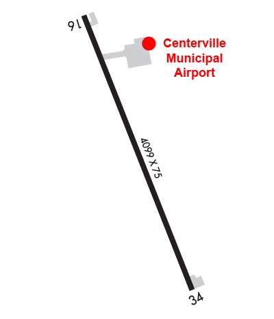
| CENTERVILLE MUNI CENTERVILLE IA |
| |
| Lat: N 4041.1 Long: W 09254.1 Elev: 1023 Var: -01 Longest Runway: 4099 | ||
| CTAF: 122.8 | ||
| ||||||||||||||||||||||||||||||||||||||||||||||||||||||||||||||||||||
| ||||||||||||||||||||||||||||||||||||||||||||||||||||||||||||||||||||
| ||||||||||||||||||||||||||||||||||||||||||||||||||||||||||||||||||||
| Rwy | Rwy | |||||||
| 4099x75 | 4099' | 4099x75 | 4099' | |||||
| Runway ID | Single Wheel | Double Wheel | Double Tandem Wheel | Dual Double Wheel |
| 16/34 | 42,000 | 65,000 | 120,000 | N/A |
| These numbers are Advisory and are not limits. The Airport Manager should have more accurate Weight Limits | ||||
 Airport Diagram might not be current. | |
| Facility Name: | CENTERVILLE MUNI |
| City Name: | CENTERVILLE |
| County: | APPANOOSE |
| State abbrev: | IA |
| State Name: | IOWA |
| Ownership: | PUBLICLY OWNED |
| Use: | OPEN TO THE PUBLIC |
| Owner's Name: | CITY OF CENTERVILLE; CHMN ARPT COMM, MARILYN VANDERLINDEN |
| Address: | PO BOX 578 312 EAST MAPLE |
| CENTERVILLE, IA 52544 | |
| Owner's Phone: | 641-895-6844 |
| Manager's Name: | KEN MERCER; OR TONY KURY |
| Address: | 20320 545TH STREET |
| CENTERVILLE, IA 52544 | |
| Phone: | 641-437-4580 |
| FAA Region: | CENTRAL |
| FAA Field Office: | NONE |
| Date | Sunrise | Sunset |
|---|---|---|
| 09/24/21 Friday | 7:01 | 19:06 |
| 09/25/21 Saturday | 7:02 | 19:04 |
| 09/26/21 Sunday | 7:03 | 19:02 |
| 09/27/21 Monday | 7:04 | 19:01 |
| 09/28/21 Tuesday | 7:05 | 18:59 |
| 09/29/21 Wednesday | 7:06 | 18:57 |
| 09/30/21 Thursday | 7:07 | 18:56 |
| 10/01/21 Friday | 7:08 | 18:54 |
| 10/02/21 Saturday | 7:09 | 18:52 |
| 10/03/21 Sunday | 7:10 | 18:51 |
| 10/04/21 Monday | 7:11 | 18:49 |
| 10/05/21 Tuesday | 7:12 | 18:47 |
| 10/06/21 Wednesday | 7:13 | 18:46 |
| 10/07/21 Thursday | 7:14 | 18:44 |
| Airport Attendance Schedule | MON - FRI 0800-1630, SAT-SUN UNATNDD; ARPT ON CALL HOLS. AFT HRS CALL AMGR ON 641-895-6844. |
| Airport Status | OPERATIONAL (This Status can change at any time - please check NOTAMS) |
| Airport Lighting Schedule | ACTVT REIL RWY 16 & 34; PAPI RWY 16 & 34; MIRL RWY 16/34- CTAF. |
| Airport Storage Available | Tie Downs, Hanger |
| Extra Services Available | Flight Instruction, Aircraft Rental |
| Wind Indicator | YES - (lighted) |
| Control Tower | NO |
| CTAF Frequency | 122.800 |
| Unicom Frequency | 122.800 |
| Rotating Beacon Color | CLEAR-GREEN (Light Land Airport) |
| Segmented Circle | NO |
| Landing Fee | NO |
| Airport Inspected | STATE - performed by STATE AERONAUTICAL PERSONNEL |
| Inspection Date | 08/06/2020 |
| Type of Fuel Available | Grade 100LL, JET A (freeze point -40C)MOGAS; -1024-HR CREDIT CARD FUEL PUMP. |
| Airframe Repair Service | None |
| Power Plant Repair Service | None |
| Latitude | N4041.1 |
| Longitude | W09254.1 (ESTIMATED) |
| Arpt Elevation | 1023ft (SURVEYED) |
| Magnetic Variation | 01E |
| 3 miles SW | of CENTERVILLE |
| Traffic Pattern Altitude | |
| Sectional Chart | CHICAGO |
| Operations (Reported) | Yearly | Avg. Daily |
|---|---|---|
| General Aviation Transient | 1875 | 5 |
| General Aviation Local | 1875 | 5 |
| Air Taxi | 0 | 0 |
| Commerical | 0 | 0 |
| Commuter | 0 | 0 |
| Military | 0 | 0 |
| Aircraft based on Field | |
|---|---|
| General Aviation Singles | 15 |
| General Aviation Multi | 0 |
| Jet Aircraft | 0 |
| General Aviation Helicopters | 0 |
| Military Aircraft | 0 |
| Gliders | 0 |
| Ultralights | 0 |
| FSS on field | NO |
| FSS tie-in | FORT DODGE |
| FSS Phone | 1-800-WX-BRIEF |
| Who issues Notams | FOD |
| Notam D service at airport | YES |
| ARTCC Name | CHICAGO |
| Airport Certification | |
| Aircraft Rescue & Firefighting Index | None |
| Airport of Entry | No |
| Custom Landing Rights | No |
| Joint Civil/Military | No |
| Military Landing rights | YES |
| NATIONAL PLAN OF INTEGRATED AIRPORT SYSTEMS (NPIAS) |
| ASSURANCES PURSUANT TO TITLE VI, CIVIL RIGHTS ACT OF 1964 |
| GRANT AGREEMENT HAS EXPIRED; HOWEVER, AGREEMENT REMAINS IN EFFECT FOR THIS FACILITY AS LONG AS IT IS PUBLIC USE. |
| (E81) TWY LGTS ONLY AT EXIT OF RWY 15. |
| FOR CD CTC CHICAGO ARTCC AT 630-906-8921. |
Airport Communications & Frequencies:
| |||||||||
| Runway: 16 | Runway: 34 | ||
| Mag heading: | 158° | Mag heading: | 338° |
| Rwy Slope: | -.01% Down | Rwy Slope: | .01% Up |
| Approach: | Approach: | ||
| Pattern: | Left Traffic | Pattern: | Left Traffic |
| Markings: | NONPRECISION INSTRUMENT | Markings: | NONPRECISION INSTRUMENT |
| Marking Condition: | FAIR | Marking Condition: | FAIR |
| Arresting Dev: | Arresting Dev: | ||
| Lat & Long: | N4041.4 W09254.2 | Lat. & Long.: | N4040.8 W09253.9 |
| Elev: | 1020.5 ft. MSL | Elev: | 1020.1 ft. MSL |
| TCH: | 40 ft. AGL | TCH: | 40 ft. AGL |
| Visual Glide Path: | 3.00 degrees | Visual Glide Path: | 3.00 degrees |
| Displaced Threshold: | No | Displaced Threshold: | No |
| Touchdown Zone: | YES | Touchdown Zone: | YES |
| Touchdown Elev.: | 1023.0 feet | Touchdown Elev.: | 1023.0 feet |
| Visual Glide Slope: | 2-Light PAPI on LEFT side of Runway | Visual Glide Slope: | 2-Light PAPI on LEFT side of Runway |
| RVR Equipment: | RVR Equipment: | ||
| RVV Equipment: | NO | RVV Equipment: | NO |
| Approach Lights: | Approach Lights: | ||
| REIL: | YES | REIL: | YES |
| Centerline Lights: | NO | Centerline Lights: | NO |
| Touchdown lights: | NO | Touchdown lights: | NO |
| Runway Category: | Runway with a Non-precision Approach having visibility minimums greater than 3/4 mile | Runway Category: | Runway with a Non-precision Approach having visibility minimums greater than 3/4 mile |
| Declared Distances: | Declared Distances: | ||
| Obstructions: | TREES | Obstructions: | |
| Marked: | NOT Marked/Lighted | Marked: | |
| Clearance slope: | 27:1 | Clearance slope: | 50:1 |
| Obstruction height: | 20 feet AGL | Obstruction height: | |
| Dist. from runway: | 744 feet | Dist. from runway: | |
| Centerline offset: | 131 right of centerline | Centerline offset: | |
| Comments: | Comments: |
Thanks for using FltPlan.com
all rights reserved © 1999-2021 by Flight Plan LLC