
| CHERRY CAPITAL TRAVERSE CITY MI |
| |
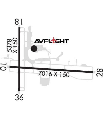
| Lat: N 4444.5 Long: W 08534.9 Elev: 624 Var: +05 Longest Runway: 7016 | ||
| Dept. ATIS: 119.17 Arr. ATIS: 119.17 Ground: 121.8 Tower: 124.2 | ||
| ||||||||||||||||||||||||||||||||||||||||||||||||||||||||||||||||||||
| ||||||||||||||||||||||||||||||||||||||||||||||||||||||||||||||||||||
| ||||||||||||||||||||||||||||||||||||||||||||||||||||||||||||||||||||
| ||||||||||||||||||||||||||||||||||||||||||||||||||||||||||||||||||||
| Rwy | Rwy | |||||||
| 7016x150 | 7016' | 110.70 - 098° | 7016x150 | 7016' | 110.70 - 278° | |||
| 5378x150 | 5106' | 5378x150 | 5378' | |||||
| Runway ID | Single Wheel | Double Wheel | Double Tandem Wheel | Dual Double Wheel |
| 10/28 | 116,000 | 193,000 | 326,000 | N/A |
| 18/36 | 79,000 | 127,000 | 215,000 | N/A |
| These numbers are Advisory and are not limits. The Airport Manager should have more accurate Weight Limits | ||||
 Airport Diagram might not be current. | |
| Facility Name: | CHERRY CAPITAL |
| City Name: | TRAVERSE CITY |
| County: | GRAND TRAVERSE |
| State abbrev: | MI |
| State Name: | MICHIGAN |
| Ownership: | PUBLICLY OWNED |
| Use: | OPEN TO THE PUBLIC |
| Owner's Name: | NORTHWEST RGNL AIRPORT AUTHORITY |
| Address: | 727 FLY DONT DR |
| TRAVERSE CITY, MI 49686-3591 | |
| Owner's Phone: | 231-947-2250 |
| Manager's Name: | KEVIN C KLEIN, AAE |
| Address: | 727 FLY DONT DR |
| TRAVERSE CITY, MI 49686-3591 | |
| Phone: | 231-947-2250 |
| FAA Region: | GREAT LAKES |
| FAA Field Office: | DET |
| Date | Sunrise | Sunset |
|---|---|---|
| 06/08/26 Monday | 5:57 | 21:26 |
| 06/09/26 Tuesday | 5:57 | 21:27 |
| 06/10/26 Wednesday | 5:56 | 21:27 |
| 06/11/26 Thursday | 5:56 | 21:28 |
| 06/12/26 Friday | 5:56 | 21:28 |
| 06/13/26 Saturday | 5:56 | 21:29 |
| 06/14/26 Sunday | 5:56 | 21:29 |
| 06/15/26 Monday | 5:56 | 21:30 |
| 06/16/26 Tuesday | 5:56 | 21:30 |
| 06/17/26 Wednesday | 5:56 | 21:30 |
| 06/18/26 Thursday | 5:56 | 21:31 |
| 06/19/26 Friday | 5:56 | 21:31 |
| 06/20/26 Saturday | 5:56 | 21:31 |
| 06/21/26 Sunday | 5:57 | 21:32 |
| Airport Attendance Schedule | 7 Days A Week 0400-0100; DURG HRS WHEN ARPT IS UNATNDD CALL ARPT OPNS 231-313-0928. FOR FBO HRS OF OPS CALL 231-929-1126. |
| Airport Status | OPERATIONAL (This Status can change at any time - please check NOTAMS) |
| Airport Lighting Schedule | WHEN ATCT CLSD ACTVT MALSR RWY 10 & 28; HIRL RWY 10/28; MIRL RWY 18/36 - CTAF. PAPI RWY 10 & 28; VASI RWY 18 & 36 OPR CONSLY. |
| Airport Storage Available | Tie Downs, Hanger |
| Extra Services Available | Air Freight, Crop Dusting, Air Ambulance, Avionics, Cargo Handling, Charter, Flight Instruction, Aircraft Rental |
| Wind Indicator | YES - (lighted) |
| Control Tower | YES |
| CTAF Frequency | 124.200 |
| Unicom Frequency | 122.950 |
| Rotating Beacon Color | WG |
| Segmented Circle | YES |
| Landing Fee | YES |
| Airport Inspected | FEDERAL - performed by FAA AIRPORTS FIELD PERSONNEL |
| Inspection Date | 09/18/2025 |
| Type of Fuel Available | Grade 100LL, JET A; -10100LL SELF SVC FUEL AVBL WITH CREDIT CARD DURG FBO HRS ONLY. |
| Airframe Repair Service | MAJOR |
| Power Plant Repair Service | MAJOR |
| Latitude | N4444.5 |
| Longitude | W08534.9 (ESTIMATED) |
| Arpt Elevation | 623ft (SURVEYED) |
| Magnetic Variation | 05W |
| 2 miles S | of TRAVERSE CITY |
| Traffic Pattern Altitude | |
| Sectional Chart | GREEN BAY |
| Operations (Reported) | Yearly | Avg. Daily |
|---|---|---|
| General Aviation Transient | 0 | 0 |
| General Aviation Local | 0 | 0 |
| Air Taxi | 0 | 0 |
| Commerical | 0 | 0 |
| Commuter | 0 | 0 |
| Military | 0 | 0 |
| Aircraft based on Field | |
|---|---|
| General Aviation Singles | 0 |
| General Aviation Multi | 0 |
| Jet Aircraft | 0 |
| General Aviation Helicopters | 0 |
| Military Aircraft | 0 |
| Gliders | 0 |
| Ultralights | 0 |
| FSS on field | NO |
| FSS tie-in | LANSING |
| FSS Phone | 1-800-WX-BRIEF |
| Who issues Notams | TVC |
| Notam D service at airport | YES |
| ARTCC Name | MINNEAPOLIS |
| Airport Certification | AIRPORT RECEIVING SCHEDULED AIR CARRIER SERVICE FROM CARRIERS CERTIFICATED BY THE CIVIL AERONAUTICS BOARD; 48 HR PPR FOR UNSKED ACR OPS WITH OVER 30 PSGR SEATS - CALL AMGR. |
| Aircraft Rescue & Firefighting Index | AIRPORT HAS A CERTIFICATE UNDER CFR PART 139 |
| Airport of Entry | No |
| Custom Landing Rights | No |
| Joint Civil/Military | No |
| Military Landing rights | YES |
| NATIONAL PLAN OF INTEGRATED AIRPORT SYSTEMS (NPIAS) |
| GRANT AGREEMENTS UNDER FAAP/ADAP/AIP |
| SURPLUS PROPERTY AGREEMENT UNDER PUBLIC LAW 289 |
| ADVANCE PLANNING AGREEMENT UNDER FAAP |
| ASSURANCES PURSUANT TO TITLE VI, CIVIL RIGHTS ACT OF 1964 |
| AGREEMENT UNDER DLAND OR DCLA HAS EXPIRED. |
| ALL TSNT ACFT CHRGD LDG, OVNGT RAMP PRKG FEE EXC MIL. |
| FOR CD WHEN ATCT IS CLSD CTC FSS VIA RCO, IF UNA CTC MINNEAPOLIS ARTCC AT 651-463-5588. |
| COLD TEMPERATURE AIRPORT. ALTITUDE CORRECTION REQUIRED AT OR BELOW -21C. |
| 48 HR PPR FOR UNSKED ACR OPS GTR THAN 100000 LB. PPR FOR ACFT OPS WITH WINGSPAN GTR THAN 118 FT. PPR FOR ACFT OPS GTR THAN 12500 LB FOR TWY J & EAST RAMP. TWY C-2/C-3 EAST OF TWY C NOT AVBL TO ACR ACFT. PPR FOR ACFT OPS GTR THAN 60000 LB ON NORTH RAMP. NORTH RAMP CLSD TO ACFT OPS GTR THAN 100000 LB. NO GA ACFT ON THE ACR RAMP. NO ACFT WITH WINGSPAN GTR THAN 40 FT BTN GA RAMP & SOUTH RAMP. PUSHBACK ADZYS ON THE TRML RAMP ARE NOT PRVDD BY ATC. DIVERTING NON-BASED ACR ACFT CTC ARPT OPS AT 231-313-0928 PRIOR TO DIVERTING. NO CUST SVC AVBL. |
| BIRDS ON AND INVOF ARPT. |
| SNOW REMOVAL OPNS IN PROGRESS WINTER MONTHS; SNOW COMMAND WILL BE MONITORING CTAF DURING NON-ATCT HOURS. ACFT LNDG/DEPARTING TVC SHOULD ANNOUNCE THEIR INTENTIONS ON CTAF WHEN ATCT CLSD. |
| TWY C-2/C-3 EAST OF TWY C NOT AVBL TO ACR ACFT. |
| FLIGHT CREWS SHOULD READ BACK ALL ADZY INFO PRVDD BY SNOW COMMAND. |
| ARPT SFC COND UNMON BTN 0100 - 0400. |
| USCG - PPR CTC TRAVERSE CITY FM 21 PRIMARY, 345.0 SECONDARY 15 MINS PRIOR TO ENTERING CG RAMP. |
| PARASAILING OPNS 1.5 NM NORTHEAST OF ARPT FROM MEMORIAL DAY TO LABOR DAY 600 FT AGL FROM SR-SS DAILY. |
| RWY 10/2 8 PCR VALUE: 470/F/B/X/T |
| RWY 18/3 6 PCR VALUE: 310/F/B/X/T |
Airport Communications & Frequencies:
| |||||||||||||||||||
| Runway: 10 | Runway: 28 | ||
| Mag heading: | 99° | Mag heading: | 279° |
| Rwy Slope: | -.24% Down | Rwy Slope: | .24% Up |
| Approach: | ILS/DME | Approach: | ILS |
| Pattern: | Left Traffic | Pattern: | Left Traffic |
| Markings: | PRECISION INSTRUMENT | Markings: | PRECISION INSTRUMENT |
| Marking Condition: | GOOD | Marking Condition: | GOOD |
| Arresting Dev: | Arresting Dev: | ||
| Lat & Long: | N4444.5 W08535.5 | Lat. & Long.: | N4444.4 W08533.8 |
| Elev: | 623.9 ft. MSL | Elev: | 606.9 ft. MSL |
| TCH: | 55 ft. AGL | TCH: | 45 ft. AGL |
| Visual Glide Path: | 3.00 degrees | Visual Glide Path: | 3.00 degrees |
| Displaced Threshold: | No | Displaced Threshold: | No |
| Touchdown Zone: | YES | Touchdown Zone: | YES |
| Touchdown Elev.: | 623.9 feet | Touchdown Elev.: | 616.0 feet |
| Visual Glide Slope: | 4-Light PAPI on LEFT side of Runway | Visual Glide Slope: | 4-Light PAPI on LEFT side of Runway |
| RVR Equipment: | RVR Equipment: | ||
| RVV Equipment: | NO | RVV Equipment: | NO |
| Approach Lights: | MALSR - 1,400 foot medium intensity approach lighting system with runway alignment indicator lights | Approach Lights: | MALSR - 1,400 foot medium intensity approach lighting system with runway alignment indicator lights |
| REIL: | NO | REIL: | NO |
| Centerline Lights: | NO | Centerline Lights: | NO |
| Touchdown lights: | NO | Touchdown lights: | NO |
| Runway Category: | Runway with a Non-precision Approach having visibility minimums greater than 3/4 mile | Runway Category: | Precision Instrument Runway |
| Declared Distances: | TORA:7016' TODA:7016' ASDA:7016' LDA:7016' | Declared Distances: | TORA:7016' TODA:7016' ASDA:7016' LDA:7016' |
| Obstructions: | TREE | Obstructions: | TOWER |
| Marked: | NOT Marked/Lighted | Marked: | LIGHTED |
| Clearance slope: | 37:1 | Clearance slope: | 36:1 |
| Obstruction height: | 80 feet AGL | Obstruction height: | 452 feet AGL |
| Dist. from runway: | 3209 feet | Dist. from runway: | 16493 feet |
| Centerline offset: | 187 right of centerline | Centerline offset: | 2359 feet left of centerline |
| Comments: | Comments: |
| Runway: 18 | Runway: 36 | ||
| Mag heading: | 185° | Mag heading: | 5° |
| Rwy Slope: | .12% Up | Rwy Slope: | -.12% Down |
| Approach: | Approach: | ||
| Pattern: | Left Traffic | Pattern: | Left Traffic |
| Markings: | NONPRECISION INSTRUMENT | Markings: | NONPRECISION INSTRUMENT |
| Marking Condition: | GOOD | Marking Condition: | GOOD |
| Arresting Dev: | Arresting Dev: | ||
| Lat & Long: | N4445.0 W08535.3 | Lat. & Long.: | N4444.1 W08535.3 |
| Elev: | 616.8 ft. MSL | Elev: | 623.4 ft. MSL |
| TCH: | 47 ft. AGL | TCH: | 53 ft. AGL |
| Visual Glide Path: | 3.00 degrees | Visual Glide Path: | 3.50 degrees |
| Displaced Threshold: | 272 feet | Displaced Threshold: | No |
| Touchdown Zone: | YES | Touchdown Zone: | YES |
| Touchdown Elev.: | 622.4 feet | Touchdown Elev.: | 623.6 feet |
| Visual Glide Slope: | 4-BOX VASI ON LEFT SIDE OF RUNWAY | Visual Glide Slope: | 4-BOX VASI ON LEFT SIDE OF RUNWAY |
| RVR Equipment: | RVR Equipment: | ||
| RVV Equipment: | NO | RVV Equipment: | NO |
| Approach Lights: | Approach Lights: | ||
| REIL: | NO | REIL: | NO |
| Centerline Lights: | NO | Centerline Lights: | NO |
| Touchdown lights: | NO | Touchdown lights: | NO |
| Runway Category: | Runway with a Non-precision Approach having visibility minimums greater than 3/4 mile | Runway Category: | Runway with a Non-precision Approach having visibility minimums greater than 3/4 mile |
| Declared Distances: | TORA:5378' TODA:5378' ASDA:5108' LDA:4838' | Declared Distances: | TORA:5378' TODA:5378' ASDA:5108' LDA:5108' |
| Obstructions: | TREE | Obstructions: | FENCE |
| Marked: | NOT Marked/Lighted | Marked: | NOT Marked/Lighted |
| Clearance slope: | 14:1; DTHR APCH SLOPE 19:1. | Clearance slope: | 40:1 |
| Obstruction height: | 70 feet AGL | Obstruction height: | 14 feet AGL |
| Dist. from runway: | 1199 feet | Dist. from runway: | 769 feet |
| Centerline offset: | 148 left of centerline | Centerline offset: | |
| Comments: | Comments: |
Thanks for using FltPlan.com
all rights reserved © 1999-2026 by Flight Plan LLC


