| TUCSON INTL TUCSON AZ |
| |
| Lat: N 3207.0 Long: W 11056.5 Elev: 2643 Var: -09 Longest Runway: 10996 | ||
| Clr Del: 126.65 Dept. ATIS: 123.8 Arr. ATIS: 123.8 Ground: 120.02 Tower: 118.3/119.0 | ||
| |||||||||||||||||||||||||||||||||||||||||||||||||||||||||||||||||||||
| |||||||||||||||||||||||||||||||||||||||||||||||||||||||||||||||||||||
| |||||||||||||||||||||||||||||||||||||||||||||||||||||||||||||||||||||
| |||||||||||||||||||||||||||||||||||||||||||||||||||||||||||||||||||||
| |||||||||||||||||||||||||||||||||||||||||||||||||||||||||||||||||||||
| |||||||||||||||||||||||||||||||||||||||||||||||||||||||||||||||||||||
| |||||||||||||||||||||||||||||||||||||||||||||||||||||||||||||||||||||
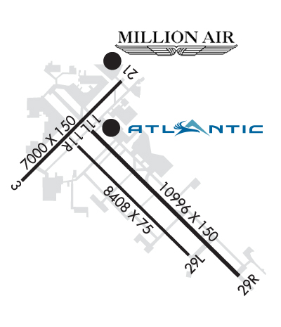
| Rwy | Rwy | |||||||
| 7000x150 | 6150' | 7000x150 | 7000' | |||||
| 10996x150 | 10996' | 111.70 - 126° | 10996x150 | 10996' | ||||
| Runway ID | Single Wheel | Double Wheel | Double Tandem Wheel | Dual Double Wheel |
| 04/22 | 119,000 | 209,000 | 393,000 | 830,000 |
| 12/30 | 120,000 | 214,000 | 405,000 | 918,000 |
| These numbers are Advisory and are not limits. The Airport Manager should have more accurate Weight Limits | ||||
 Airport Diagram might not be current. | |
| Facility Name: | TUCSON INTL |
| City Name: | TUCSON |
| County: | PIMA |
| State abbrev: | AZ |
| State Name: | ARIZONA |
| Ownership: | PUBLICLY OWNED |
| Use: | OPEN TO THE PUBLIC |
| Owner's Name: | TUCSON AIRPORT AUTHORITY |
| Address: | 7250 SOUTH TUCSON BLVD, SUITE 300 |
| TUCSON, AZ 85756 | |
| Owner's Phone: | 520-573-8100 |
| Manager's Name: | DANETTE BEWLEY; ADAM MERRILL 520-573-5112. |
| Address: | TUCSON APT AUTH 7250 S TUCSON BLVD, SUITE 300 |
| TUCSON, AZ 85756 | |
| Phone: | 520-573-4820 |
| FAA Region: | WESTERN-PACIFIC |
| FAA Field Office: | PHX |

| Date | Sunrise | Sunset |
|---|---|---|
| 06/07/26 Sunday | 5:17 | 19:28 |
| 06/08/26 Monday | 5:17 | 19:29 |
| 06/09/26 Tuesday | 5:17 | 19:29 |
| 06/10/26 Wednesday | 5:17 | 19:30 |
| 06/11/26 Thursday | 5:17 | 19:30 |
| 06/12/26 Friday | 5:17 | 19:30 |
| 06/13/26 Saturday | 5:17 | 19:31 |
| 06/14/26 Sunday | 5:17 | 19:31 |
| 06/15/26 Monday | 5:17 | 19:32 |
| 06/16/26 Tuesday | 5:17 | 19:32 |
| 06/17/26 Wednesday | 5:17 | 19:32 |
| 06/18/26 Thursday | 5:17 | 19:32 |
| 06/19/26 Friday | 5:17 | 19:33 |
| 06/20/26 Saturday | 5:18 | 19:33 |
| Airport Attendance Schedule | CONTINUOUS |
| Airport Status | OPERATIONAL (This Status can change at any time - please check NOTAMS) |
| Airport Lighting Schedule | SS-SR |
| Airport Storage Available | Tie Downs |
| Extra Services Available | Air Freight, Air Ambulance, Avionics, Cargo Handling, Charter, Flight Instruction, Aircraft Rental, Aircraft Sales, Annual Surveying |
| Wind Indicator | YES - (lighted) |
| Control Tower | YES |
| CTAF Frequency | |
| Unicom Frequency | 122.950 |
| Rotating Beacon Color | WG |
| Segmented Circle | NO |
| Landing Fee | NO |
| Airport Inspected | FEDERAL - performed by FAA AIRPORTS FIELD PERSONNEL |
| Inspection Date | 03/20/2025 |
| Type of Fuel Available | Grade 100LL, JET A (freeze point -40C)A++ |
| Airframe Repair Service | MAJOR |
| Power Plant Repair Service | MAJOR |
| Latitude | N3207.0 |
| Longitude | W11056.5 (ESTIMATED) |
| Arpt Elevation | 2643ft (SURVEYED) |
| Magnetic Variation | 09E |
| 6 miles S | of TUCSON |
| Traffic Pattern Altitude | 800; TPA 800 FT AGL SMALL ACFT; 1400 FT AGL LARGE/HEAVY TURBOJET ACFT. |
| Sectional Chart | PHOENIX |
| Operations (Reported) | Yearly | Avg. Daily |
|---|---|---|
| General Aviation Transient | 0 | 0 |
| General Aviation Local | 0 | 0 |
| Air Taxi | 0 | 0 |
| Commerical | 0 | 0 |
| Commuter | 0 | 0 |
| Military | 0 | 0 |
| Aircraft based on Field | |
|---|---|
| General Aviation Singles | 0 |
| General Aviation Multi | 0 |
| Jet Aircraft | 0 |
| General Aviation Helicopters | 0 |
| Military Aircraft | 0 |
| Gliders | 0 |
| Ultralights | 0 |
| FSS on field | NO |
| FSS tie-in | PRESCOTT |
| FSS Phone | 1-800-WX-BRIEF |
| Who issues Notams | TUS |
| Notam D service at airport | YES |
| ARTCC Name | ALBUQUERQUE |
| Airport Certification | AIRPORT RECEIVING SCHEDULED AIR CARRIER SERVICE FROM CARRIERS CERTIFICATED BY THE CIVIL AERONAUTICS BOARD |
| Aircraft Rescue & Firefighting Index | AIRPORT HAS A CERTIFICATE UNDER CFR PART 139 |
| Airport of Entry | YES |
| Custom Landing Rights | No |
| Joint Civil/Military | No |
| Military Landing rights | YES |
| NATIONAL PLAN OF INTEGRATED AIRPORT SYSTEMS (NPIAS) |
| GRANT AGREEMENTS UNDER FAAP/ADAP/AIP |
| SURPLUS PROPERTY AGREEMENT UNDER PUBLIC LAW 289 |
| CONVEYANCE UNDER SCETION 16, FEDERAL AIRPORT ACT OF 1946 OR SECTION 23, AIRPORT AND AIRWAY DEVELOPMENT ACT OF 1970 |
| ASSURANCES PURSUANT TO TITLE VI, CIVIL RIGHTS ACT OF 1964 |
| AGREEMENT UNDER DLAND OR DCLA HAS EXPIRED. |
| CTN: NW ARR & DEP DO NOT MISTAKE TWY A FOR LNDG SFC; TWY A N & PARL TO RWY 30. |
| GROUP V TAX WITH INBOARD ENG ONLY. TRML RAMP CLSD TO ADG IV & ABV WO PPR. |
| PTNS TWY D NOT VIS FM ATCT. |
| A GEAR - BAK-14 BAK-12B APCH END RWY 12, BAK-14 BAK-12B APCH END RWY 30 & BAK-14 BAK-12B APCH END RWY 22 AVBL DURG ANG DUTY HR: 5 MIN PN. |
| TWY A5 LTD 70000 LB OR LESS. |
| MIL: ANG OFFL BUS ONLY; 72 HR PPR - D844-6731/C520-295-6731; FAX EXTN 6732. BASE OPS 1300Z-2230Z MON-FRI & DRILL WKEND 1300Z-2130Z; CLSD OTR WKENDS, HOL & SKED OFF DAYS. TRAN ALERT MAINT NA. TSNT SI FSL ONLY. CONTR FUEL NA. |
| USE UPPER ANT UNTIL AIRBORNE. |
| CHARTER, SPORT TEAM, CARGO & MIL PPR - FBO. LNDG & PRKG FEE 12500 LBS & UP. |
| MIL/COMM/BASE OPS ARR CTC TITAN OR PUMA - ANG BASE OPS/COMD POST FREQ. |
| MIL: BIRD ACT PHASE II IN EFCT 1 JUL-31 AUG. |
| USCBP INSP RAMP RFLG NA EXC MED EMERG. |
| GEN INFO - 520-573-8182. |
| CTN: REVIEW ARPT DIAGRAM HOT SPOT INFO. |
| OPR PARROT ALL SFCS, PUSHBACK & GATE ARR. |
| N RAMP CLSD TO WINGSPAN GTR THAN 79 FT. |
| TXL K CLSD TO WINGSPAN GTR THAN 104 FT. |
| TWY C CLSD TO WINGSPAN GTR THAN 118 FT & TAIL HGT GTR THAN 45 FT. |
| FLT TRNG 2200-0600 NA EXC PPR - 520-573-8190. |
| RWY 12/3 0 FIXED WING JET VSTOL/VTOL OPS NA. DSTC RMNG MKRS NE SIDE. |
| RWY 30 CTN: ENSURE DEP RWY; DO NOT MISTAKE FOR DEMOL RWY. |
| RWY 04/2 2 PCR VALUE: 470/F/A/X/T |
| RWY 12/3 0 PCR VALUE: 650/R/A/W/T |
| RWY 12/3 0 EXCEEDS 200 FT SPACING AT TWY INTXN ON N & S SIDE OF RWY. |
Airport Communications & Frequencies:
| ||||||||||||||||||||||||||||||||||||||||||||||||||||||||||||||||||||||||||||||
| Runway: 04 | Runway: 22 | ||
| Mag heading: | 36° | Mag heading: | 216° |
| Rwy Slope: | .12% Up | Rwy Slope: | -.12% Down |
| Approach: | Approach: | ||
| Pattern: | Left Traffic | Pattern: | Right Traffic |
| Markings: | NONPRECISION INSTRUMENT | Markings: | NONPRECISION INSTRUMENT |
| Marking Condition: | GOOD | Marking Condition: | GOOD |
| Arresting Dev: | BAK-12B,BAK-14; BAK-14 BAK-12B(B) (1500). | Arresting Dev: | |
| Lat & Long: | N3207.0 W11057.5 | Lat. & Long.: | N3207.8 W11056.6 |
| Elev: | 2560.2 ft. MSL | Elev: | 2568.8 ft. MSL |
| TCH: | TCH: | 53 ft. AGL | |
| Visual Glide Path: | Visual Glide Path: | 3.00 degrees | |
| Displaced Threshold: | 850 feet | Displaced Threshold: | No |
| Touchdown Zone: | YES | Touchdown Zone: | YES |
| Touchdown Elev.: | 2572.1 feet | Touchdown Elev.: | 2572.4 feet |
| Visual Glide Slope: | Visual Glide Slope: | 4-Light PAPI on LEFT side of Runway | |
| RVR Equipment: | RVR Equipment: | ||
| RVV Equipment: | NO | RVV Equipment: | NO |
| Approach Lights: | Approach Lights: | ||
| REIL: | NO | REIL: | YES |
| Centerline Lights: | NO | Centerline Lights: | NO |
| Touchdown lights: | NO | Touchdown lights: | NO |
| Runway Category: | Runway with a Non-precision Approach having visibility minimums greater than 3/4 mile | Runway Category: | Runway with a Non-precision Approach having visibility minimums greater than 3/4 mile |
| Declared Distances: | TORA:7000' TODA:7000' ASDA:7000' LDA:6150' | Declared Distances: | TORA:6000' TODA:7000' ASDA:6000' LDA:6000' |
| Obstructions: | RR | Obstructions: | Unknown |
| Marked: | NOT Marked/Lighted | Marked: | NOT Marked/Lighted |
| Clearance slope: | 3:1 | Clearance slope: | 30:1 |
| Obstruction height: | 21 feet AGL | Obstruction height: | 40 feet AGL |
| Dist. from runway: | 270 feet | Dist. from runway: | 1400 feet |
| Centerline offset: | 250 left of centerline | Centerline offset: | 300 feet right of centerline |
| Comments: | Comments: |
| Runway: 12 | Runway: 30 | ||
| Mag heading: | 126° | Mag heading: | 306° |
| Rwy Slope: | .59% Up | Rwy Slope: | -.59% Down |
| Approach: | ILS/DME | Approach: | |
| Pattern: | Left Traffic | Pattern: | Right Traffic |
| Markings: | PRECISION INSTRUMENT | Markings: | NONPRECISION INSTRUMENT |
| Marking Condition: | GOOD | Marking Condition: | GOOD |
| Arresting Dev: | BAK-14; BAK-14 BAK-12B(B) (1000). | Arresting Dev: | BAK-12B,BAK-14; BAK-14 BAK-12(B) (1215) HOOK BAK 12B(B) (128 OVRN). |
| Lat & Long: | N3207.4 W11056.9 | Lat. & Long.: | N3206.1 W11055.4 |
| Elev: | 2577.7 ft. MSL | Elev: | 2643.0 ft. MSL |
| TCH: | 73 ft. AGL | TCH: | 81 ft. AGL |
| Visual Glide Path: | 3.00 degrees | Visual Glide Path: | 3.00 degrees |
| Displaced Threshold: | No | Displaced Threshold: | No |
| Touchdown Zone: | YES | Touchdown Zone: | YES |
| Touchdown Elev.: | 2598.6 feet | Touchdown Elev.: | 2643.0 feet |
| Visual Glide Slope: | 4-Light PAPI on LEFT side of Runway | Visual Glide Slope: | 4-Light PAPI on LEFT side of Runway |
| RVR Equipment: | TOUCHDOWN | RVR Equipment: | ROLLOUT |
| RVV Equipment: | NO | RVV Equipment: | NO |
| Approach Lights: | MALSR - 1,400 foot medium intensity approach lighting system with runway alignment indicator lights | Approach Lights: | |
| REIL: | NO | REIL: | YES |
| Centerline Lights: | NO | Centerline Lights: | NO |
| Touchdown lights: | NO | Touchdown lights: | NO |
| Runway Category: | Precision Instrument Runway | Runway Category: | Runway with a Non-precision Approach having visibility minimums greater than 3/4 mile |
| Declared Distances: | TORA:10996' TODA:10996' ASDA:10996' LDA:10996' | Declared Distances: | TORA:10996' TODA:10996' ASDA:10996' LDA:10996' |
| Obstructions: | Obstructions: | GND | |
| Marked: | Marked: | NOT Marked/Lighted | |
| Clearance slope: | 50:1 | Clearance slope: | 25:1 |
| Obstruction height: | Obstruction height: | 8 feet AGL | |
| Dist. from runway: | Dist. from runway: | 400 feet | |
| Centerline offset: | Centerline offset: | 500 feet right of centerline | |
| Comments: | Comments: |
Thanks for using FltPlan.com
all rights reserved © 1999-2026 by Flight Plan LLC