
| TUPELO RGNL TUPELO MS |
| |
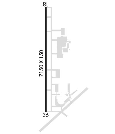
| Lat: N 3416.1 Long: W 08846.2 Elev: 347 Var: +02 Longest Runway: 7150 | ||
| AWOS: 133.52 Ground: 121.82 Tower: 118.77 | ||
| ||||||
| ||||||
|
| Rwy | Rwy | |||||||
| 7150x150 | 7150' | 7150x150 | 7150' | 108.50 - 001° | ||||
| Runway ID | Single Wheel | Double Wheel | Double Tandem Wheel | Dual Double Wheel |
| 18/36 | 69,000 | 91,000 | 168,000 | N/A |
| These numbers are Advisory and are not limits. The Airport Manager should have more accurate Weight Limits | ||||
 Airport Diagram might not be current. | |
| Facility Name: | TUPELO RGNL |
| City Name: | TUPELO |
| County: | LEE |
| State abbrev: | MS |
| State Name: | MISSISSIPPI |
| Ownership: | PUBLICLY OWNED |
| Use: | OPEN TO THE PUBLIC |
| Owner's Name: | TUPELO AIRPORT AUTHORITY |
| Address: | 2704 W JACKSON ST |
| TUPELO, MS 38801 | |
| Owner's Phone: | 662-823-2375; EXT 8. |
| Manager's Name: | BRANDON PANNELL |
| Address: | 2704 W JACKSON ST |
| TUPELO, MS 38801 | |
| Phone: | 662-841-6570 |
| FAA Region: | SOUTHERN |
| FAA Field Office: | JAN |
| Date | Sunrise | Sunset |
|---|---|---|
| 06/08/26 Monday | 5:43 | 20:06 |
| 06/09/26 Tuesday | 5:43 | 20:06 |
| 06/10/26 Wednesday | 5:43 | 20:07 |
| 06/11/26 Thursday | 5:43 | 20:07 |
| 06/12/26 Friday | 5:42 | 20:07 |
| 06/13/26 Saturday | 5:42 | 20:08 |
| 06/14/26 Sunday | 5:43 | 20:08 |
| 06/15/26 Monday | 5:43 | 20:09 |
| 06/16/26 Tuesday | 5:43 | 20:09 |
| 06/17/26 Wednesday | 5:43 | 20:09 |
| 06/18/26 Thursday | 5:43 | 20:09 |
| 06/19/26 Friday | 5:43 | 20:10 |
| 06/20/26 Saturday | 5:43 | 20:10 |
| 06/21/26 Sunday | 5:43 | 20:10 |
| Airport Attendance Schedule | 7 Days A Week 0600-2200 |
| Airport Status | OPERATIONAL (This Status can change at any time - please check NOTAMS) |
| Airport Lighting Schedule | ACTVT MALSR RWY 36; REIL RWY 18; HIRL 18/36 - CTAF. PAPI RWY 18 & 36 OPR CONSLY. |
| Airport Storage Available | Tie Downs, Hanger, Buoys |
| Extra Services Available | Crop Dusting, Flight Instruction, Aircraft Rental |
| Wind Indicator | YES - (lighted) |
| Control Tower | YES |
| CTAF Frequency | 118.775 |
| Unicom Frequency | |
| Rotating Beacon Color | WG |
| Segmented Circle | YES |
| Landing Fee | NO |
| Airport Inspected | FEDERAL - performed by FAA AIRPORTS FIELD PERSONNEL |
| Inspection Date | 04/17/2026 |
| Type of Fuel Available | Grade 100LL, JET A (freeze point -40C), JET A, JET A-1 (icing inhibitor, freeze point -50C); -A+FUEL SVC AVBL 24 HRS WITH CREDIT CARD. |
| Airframe Repair Service | MAJOR |
| Power Plant Repair Service | MAJOR |
| Latitude | N3416.1 |
| Longitude | W08846.2 (ESTIMATED) |
| Arpt Elevation | 346ft (SURVEYED) |
| Magnetic Variation | 02W |
| 3 miles W | of TUPELO |
| Traffic Pattern Altitude | |
| Sectional Chart | MEMPHIS |
| Operations (Reported) | Yearly | Avg. Daily |
|---|---|---|
| General Aviation Transient | 0 | 0 |
| General Aviation Local | 0 | 0 |
| Air Taxi | 0 | 0 |
| Commerical | 0 | 0 |
| Commuter | 0 | 0 |
| Military | 0 | 0 |
| Aircraft based on Field | |
|---|---|
| General Aviation Singles | 0 |
| General Aviation Multi | 0 |
| Jet Aircraft | 0 |
| General Aviation Helicopters | 0 |
| Military Aircraft | 0 |
| Gliders | 0 |
| Ultralights | 0 |
| FSS on field | NO |
| FSS tie-in | GREENWOOD |
| FSS Phone | 1-800-WX-BRIEF |
| Who issues Notams | TUP |
| Notam D service at airport | YES |
| ARTCC Name | MEMPHIS |
| Airport Certification | AIRPORT RECEIVING SCHEDULED AIR CARRIER SERVICE FROM CARRIERS CERTIFICATED BY THE CIVIL AERONAUTICS BOARD; PPR FOR UNSKED ACR OPS WITH MORE THAN 30 PAX SEATS CALL AMGR 662-841-6570. INDEX B ARFF EQPT AVBL ONLY DURING SKED ACR OPS. |
| Aircraft Rescue & Firefighting Index | AIRPORT HAS A CERTIFICATE UNDER CFR PART 139 |
| Airport of Entry | No |
| Custom Landing Rights | No |
| Joint Civil/Military | No |
| Military Landing rights | YES |
| NATIONAL PLAN OF INTEGRATED AIRPORT SYSTEMS (NPIAS) |
| GRANT AGREEMENTS UNDER FAAP/ADAP/AIP |
| ASSURANCES PURSUANT TO TITLE VI, CIVIL RIGHTS ACT OF 1964 |
| CAUTION: HEL OPS ALL HRS 700 FT AGL E OF RWY 18/36 - CTC CTAF FOR ADZY. |
| ACR RAMP RSTRD TO ACR OPS EXCP WITH PPR. CALL AMGR MON-FRI 0800-1700; 662-841-6570. |
| ARNG: SUPPORT FAC OPR 1300-2200Z++ MON-FRI EXC HOL. LTD PRK AVBL. NO TSNT FUEL AVBL. DSN 293-3438, C662-891-4438. |
| RWY 18/3 6 PCR VALUE: 72/F/C/W/T |
Airport Communications & Frequencies:
| |||||||||||||||
| Runway: 18 | Runway: 36 | ||
| Mag heading: | 182° | Mag heading: | 2° |
| Rwy Slope: | .05% Up | Rwy Slope: | -.05% Down |
| Approach: | Approach: | ILS/DME | |
| Pattern: | Left Traffic | Pattern: | Left Traffic |
| Markings: | NONPRECISION INSTRUMENT | Markings: | PRECISION INSTRUMENT |
| Marking Condition: | GOOD | Marking Condition: | GOOD |
| Arresting Dev: | Arresting Dev: | ||
| Lat & Long: | N3416.7 W08846.2 | Lat. & Long.: | N3415.6 W08846.2 |
| Elev: | 342.9 ft. MSL | Elev: | 346.5 ft. MSL |
| TCH: | 45 ft. AGL | TCH: | 55 ft. AGL |
| Visual Glide Path: | 3.00 degrees | Visual Glide Path: | 3.00 degrees |
| Displaced Threshold: | No | Displaced Threshold: | No |
| Touchdown Zone: | YES | Touchdown Zone: | YES |
| Touchdown Elev.: | 344.0 feet | Touchdown Elev.: | 346.5 feet |
| Visual Glide Slope: | 4-Light PAPI on LEFT side of Runway | Visual Glide Slope: | 4-Light PAPI on LEFT side of Runway |
| RVR Equipment: | RVR Equipment: | ||
| RVV Equipment: | NO | RVV Equipment: | NO |
| Approach Lights: | Approach Lights: | MALSR - 1,400 foot medium intensity approach lighting system with runway alignment indicator lights | |
| REIL: | YES | REIL: | NO |
| Centerline Lights: | NO | Centerline Lights: | NO |
| Touchdown lights: | NO | Touchdown lights: | NO |
| Runway Category: | Runway with a Non-precision Approach having visibility minimums greater than 3/4 mile | Runway Category: | Precision Instrument Runway |
| Declared Distances: | Declared Distances: |
Thanks for using FltPlan.com
all rights reserved © 1999-2026 by Flight Plan LLC
