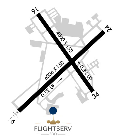
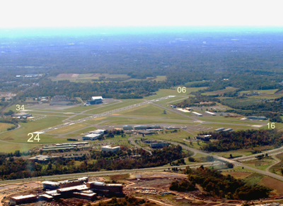
TTN  /  KTTN Airport & FBO Info       TRENTON MERCER     TRENTON NJ
FltPlan.com
Airport/FBO Info
  Tutorial    Disclaimer    E-Mail Support
Using the 3 or 4 Letter Airport ID:

Printout Size
Full
Compact
 OR
Using the Airport or City Name:  
Minimum 4 letters
Do not use the state in search.

 Airport / FBO Information  
TTN       TRENTON MERCER       TRENTON       NJ
  Time Zone: ET 
Lat: N 4016.6     Long: W 07448.8     Elev: 213     Var: +12  Longest Runway: 6006
Clr Del: 121.9       Dept. ATIS: 126.77     Arr. ATIS: 126.77     AWOS: 133.7   Ground: 121.9     Tower: 120.7

FBO info for KTTN:      
Complete 24 Hour Line Service, Professionally Trained Line Crew, Quick Turnarounds, Pilot Lounge with Internet Access and Satellite TV, Executive Conference Room, Passenger Lounge, Flight Planning Room, Tie-down and Heated Hangars, Customs On Site, Courtesy Van and Crew Cars, Limousine and Taxi Services, Avis, Budget and Hertz On Site with Reservation, Hotel Reservations, Catering Coordination
Ph: 609-771-9500   website E-Mail Ronson Aviation, Inc. Fax: 609-771-0885 Freq: 122.95
ASOS Ph: 609-538-8690
-
Freq: 133.7


FBO's at nearby airports who want your business:
KMMU

A Great Alternative to KTTN.
PLEASE CALL AHEAD FOR RESERVATIONS.
Our Jet-A fuel is $.50 a gallon over wholesale, the least expensive of any FBO at any major metropolitan NY airport.
All FBO services are included in the Terminal fee.
Our world-class surveillance system provides an unmatched level of security and privacy.
Our ramp is vehicle accessible.
Ph: 973-401-0106  E-Mail KMMU Fax: 973-401-0109 Freq: 130.95
KBLM

Avoid Delays, Visit BLM - 7300 foot Runway
Quick Turns - Self Serve - Wireless Internet - Crew & Passenger Lounge - Courtesy Car - Concierge Services - Catering - Volume Fuel Discounts - Phillips Pre-blended Fuel - Ground Support - Complimentary Coffee, Ice and Newspapers - Aircraft Sales
Ph: 732-751-0044  E-Mail KBLM Fax: 732-751-0199 Freq: 129.72

 Runway & Approach Info
  Rwy  
    Length    
  Land Dist Avail  
  Approach*  
    Rwy  
Length
  Land Dist Avail  
 Approach* 
06
6006x150  6006'          
ILS
 111.30 - 058º  
  
24
  6006x150  6006'          
 
16
4800x150  4800'          
 
  
34
  4800x150  4800'          
 
 * only ILS, LOC, LDA, and SDF approaches to a specific runway are shown

Runway Weight Capability   (lbs.)
Runway IDSingle WheelDouble WheelDouble Tandem WheelDual Double Wheel
06/24120,000180,000320,000N/A
16/34120,000180,000320,000N/A
H1N/AN/AN/AN/A
H2N/AN/AN/AN/A
H3N/AN/AN/AN/A


Database effective date: 06/05/2008

Airport Diagram might not be current.
Airport Diagram of KTTN
Facility Name: TRENTON MERCER
City Name: TRENTON
County: MERCER
State abbrev: NJ
State Name: NEW JERSEY
   
Ownership: PUBLICLY OWNED
Use: OPEN TO THE PUBLIC
Owner's Name: COUNTY OF MERCER
Address: 640 S BROAD ST
 TRENTON, NJ 08650
Owner's Phone: 609-989-6518
  
Manager's Name: JUSTIN P. EDWARDS
Address: 1100 TERMINAL CIRCLE DRIVE,STE. 301
 WEST TRENTON, NJ 08628
Phone: 609-882-1601
   
FAA Region: EASTERN
FAA Field Office: NYC

Click here to submit your photo
Area Map of TTN
Click Here for Rand McNally Map of TTN

Sunrise / Sunset times for:
TRENTON MERCER
Date: Sunrise Sunset
May 01, 2008 5:5819:55
June 01, 2008 5:3120:23
July 01, 2008 5:3420:33
August 01, 2008 5:5820:13
September 01, 2008 6:2719:30
October 01, 2008 6:5618:40
November 01, 2008 7:3017:55
December 01, 2008 7:0316:34
January 01, 2009 7:2216:44
February 01, 2009 7:0917:18
March 01, 2009 6:3317:51
April 01, 2009 6:4419:24

 Airport Facilities
Airport Attendance Schedule: CONTINUOUS
Airport Status: OPERATIONAL (This Status can change at any time - please check NOTAMS)
Airport Lighting Schedule: DUSK-DAWN; WHEN ATCT CLSD ACTVT HIRL RY 06/24; HIRL RY 16/34; MALSR RY 06; VASI RYS 24; 16; 34; REIL RYS 24; 16; 34 & TWY LGTS - CTAF.
Airport Storage Available: Tie Downs, Hanger
Extra Services Available: NONEFlight Instruction, Aircraft Rental, Aircraft SalesFlight Instruction, Aircraft Rental, Aircraft SalesFlight Instruction, Aircraft Rental, Aircraft SalesAvionics, Charter, Flight Instruction, Aircraft Rental, Aircraft SalesFlight Instruction, Aircraft Rental, Aircraft SalesCharter, Flight Instruction, Aircraft RentalCharter, Flight Instruction, Aircraft Rental, Aircraft SalesAvionics, Flight Instruction, Parachute Jumping, Aircraft Rental, Aircraft SalesAvionics, Cargo Handling, Charter, Aircraft SalesFlight Instruction, Aircraft Rental, Aircraft SalesCharter, Flight Instruction, Aircraft Rental, Aircraft Sales
Wind Indicator: YES - (lighted)
Control Tower: YES
CTAF Frequency: 120.700
Unicom Frequency: 122.950
Rotating Beacon Color: CLEAR-GREEN (Light Land Airport)
Segmented Circle: NO
Landing Fee: YES; LDG FEE FOR ALL TRANSIENT ACFT.

Airport Services
Type of Fuel Available: Grade 100LL, JET A (freeze point -40C); FUEL AVBL ON 24/7.
Airframe Repair Service: MAJOR
Power Plant Repair Service: MAJOR

Geographic Data
Latitude: N4016.6   Longitude: W07448.8  (ESTIMATED)
Arpt Elevation: 213ft (SURVEYED)
Magnetic Variation: 12W
4 miles NW of TRENTON
Traffic Pattern Altitude: TPA FOR ACFT UNDER 12500 LBS 1200 FT MSL; ACFT 12500 LBS & OVER 1700 FT MSL.
Sectional Chart: NEW YORK

  Aircraft Data
Operations (reported)
YearlyAvg. Daily
General Aviation transient: 59313163
General Aviation Local: 2846378
Air Taxi: 00
Commercial: 687519
Commuter: 00
Military: 30288
Aircraft based on Field
General Aviation Singles: 76
General Aviation Multi: 21
Jet Aircraft: 16
General Aviation Helicopters: 33
Military Aircraft: 19
Gliders: 0
Ultralights: 0

  FAA Services
FSS on field: NO
FSS tie-in: MILLVILLE
FSS Phone: 1-800-WX-BRIEF
Who issues Notams: TTN
Notam D service at airport: YES
ARTCC Name: WASHINGTON
 
  Federal Status
Airport Certification: AIRPORT RECEIVING SCHEDULED AIR CARRIER SERVICE FROM CARRIERS CERTIFICATED BY THE CIVIL AERONAUTICS BOARD
Aircraft Rescue & Firefighting Index: AIRPORT HAS A CERTIFICATE UNDER CFR PART 139
Airport of Entry: No
Custom Landing Rights: No; US CUSTOMS USER FEE ARPT.
Joint Civil/Military: YES
Military Landing rights: YES

Runway Identification: 06/24
Length: 6006 ft
Width: 150 ft
Surface: ASPHALT-GOOD CONDITION
Edge lights: High Intensity

Treatment: GROOVED


Runway: 06
 
Runway: 24
Mag heading:  58ºMag heading:  238º
Rwy Slope:  .53% UpRwy Slope:  -.53% Down
Approach:  ILSApproach:  
Pattern:  Left TrafficPattern:  Left Traffic
Markings:  PRECISION INSTRUMENTMarkings:  PRECISION INSTRUMENT
Marking Condition:  GOODMarking Condition:  GOOD
Arresting Dev:  Arresting Dev:  
Lat & Long:  N4016.2  W07449.3Lat. & Long.:  N4016.9  W07448.4
Elev:  160.3 ft. MSLElev:  192.4 ft. MSL
TCH:  TCH:  39 ft. AGL
Visual Glide Path:  Visual Glide Path:  3.00 degrees
Displaced Threshold:  NoDisplaced Threshold:  No
Touchdown Zone:  YESTouchdown Zone:  YES
Touchdown Elev.:  186 feetTouchdown Elev.:  192 feet
Visual Glide Slope:  Visual Glide Slope:  4-Light PAPI on LEFT side of Runway
RVR Equipment:  RVR Equipment:  
RVV Equipment:  NORVV Equipment:  NO
Approach Lights:  MALSR - 1,400 foot medium intensity approach lighting system with runway alignment indicator lightsApproach Lights:  
REIL:  NOREIL:  YES
Centerline Lights:  NOCenterline Lights:  NO
Touchdown lights:  NOTouchdown lights:  NO
Runway Catagory:  PRECISION INSTRUMENT RUNWAYRunway Catagory:  OTHER THAN UTILITY RUNWAY WITH A NON PRECISION APPROACH HAVING VISIBILITY MINIMUNS GREATHER THAN 3/4 MILE
Obstructions:  TREEObstructions:  TREE
Marked:  NOT Marked/LightedMarked:  NOT Marked/Lighted
Clearance slope:  14:1Clearance slope:  15:1
Obstruction height:  14 feet AGLObstruction height:  22 feet AGL
Dist. from runway:  400 feetDist. from runway:  550 feet
Centerline offset:  420 left of centerlineCenterline offset:  490 feet left of centerline
Comments:  RWY 06, 185 FT LGTD POLE; 100 FT FROM THRESHOLD, 500 FT R.Comments:  

Runway Identification: 16/34
Length: 4800 ft
Width: 150 ft
Surface: ASPHALT-GOOD CONDITION
Edge lights: High Intensity

Treatment: GROOVED


Runway: 16
 
Runway: 34
Mag heading:  158ºMag heading:  338º
Rwy Slope:  -.79% DownRwy Slope:  .79% Up
Approach:  Approach:  
Pattern:  Left TrafficPattern:  Left Traffic
Markings:  NONPRECISION INSTRUMENTMarkings:  NONPRECISION INSTRUMENT
Marking Condition:  GOODMarking Condition:  GOOD
Arresting Dev:  Arresting Dev:  
Lat & Long:  N4017.0  W07449.1Lat. & Long.:  N4016.4  W07448.5
Elev:  212.0 ft. MSLElev:  174.0 ft. MSL
TCH:  40 ft. AGLTCH:  50 ft. AGL
Visual Glide Path:  3.00 degreesVisual Glide Path:  3.00 degrees
Displaced Threshold:  NoDisplaced Threshold:  No
Touchdown Zone:  YESTouchdown Zone:  YES
Touchdown Elev.:  212 feetTouchdown Elev.:  203 feet
Visual Glide Slope:  4-Light PAPI on LEFT side of RunwayVisual Glide Slope:  4-Light PAPI on LEFT side of Runway
RVR Equipment:  RVR Equipment:  
RVV Equipment:  NORVV Equipment:  NO
Approach Lights:  Approach Lights:  
REIL:  YESREIL:  YES
Centerline Lights:  NOCenterline Lights:  NO
Touchdown lights:  NOTouchdown lights:  NO
Runway Catagory:  OTHER THAN UTILITY RUNWAY WITH A NON PRECISION APPROACH HAVING VISIBILITY MINIMUNS GREATHER THAN 3/4 MILERunway Catagory:  OTHER THAN UTILITY RUNWAY WITH A NON PRECISION APPROACH HAVING VISIBILITY MINIMUNS GREATHER THAN 3/4 MILE
Obstructions:  TREESObstructions:  TREE
Marked:  NOT Marked/LightedMarked:  NOT Marked/Lighted
Clearance slope:  15:1Clearance slope:  
Obstruction height:  21 feet AGLObstruction height:  26 feet AGL
Dist. from runway:  535 feetDist. from runway:  210 feet
Centerline offset:  300 left of centerlineCenterline offset:  250 feet right of centerline
Comments:  Comments:  

Runway Identification: H1 HELIPAD
Length: 64 ft
Width: 64 ft
Surface: ASPHALT-GOOD CONDITION
Edge lights:


Runway Identification: H2 HELIPAD
Length: 64 ft
Width: 64 ft
Surface: ASPHALT-GOOD CONDITION
Edge lights:


Runway Identification: H3 HELIPAD
Length: 64 ft
Width: 64 ft
Surface: ASPHALT-GOOD CONDITION
Edge lights:


Remarks
  • THIS AIRPORT HAS BEEN SURVEYED BY THE NATIONAL GEODETIC SURVEY.
  • GEESE & FLOCKS OF SEA GULLS & DEER ON & INVOF ARPT.
  • NOISE ABATEMENT PROCS IN EFCT; DEPS OVER 12500 LBS FLY RY HEADING UNTIL 1700 FT MSL; DEPS UNDER 12500 LBS FLY RY HEADING UNTIL 1200 FT MSL.
  • NO TGL OR TRAINING OPNS 2200-0700.
  • RCMD ACFT DEPG NE CLIMB AS EXPEDITIOUSLY AS PSBL TO 1500 MSL TO AVOID TWIN PINES TFC PAT; & ACFT LNDG RY 24 MAINT AT LEAST 1500 MSL TIL CLEARING THE TWIN PINES TFC PAT.
  • RWY H1 LCTD AT INTERSECTION OF TWYS 'A' & 'H'.
  • RWY H2 LCTD AT NORTHEAST END OF TWY 'B'.
  • RWY H3 LCTD ON SOUTH APRON AT TWY F.

  • Federal Agreements
  • NATIONAL PLAN OF INTEGRATED AIRPORT SYSTEMS (NPIAS)
  • GRANT AGREEMENTS UNDER FAAP/ADAP/AIP
  • SURPLUS PROPERTY AGREEMENT UNDER PUBLIC LAW 289
  • COMPLIANCE WITH ACCESSIBILITY TO THE HANDICAPPED
  • ASSURANCES PURSUANT TO TITLE VI, CIVIL RIGHTS ACT OF 1964
  • AGREEMENT UNDER DLAND OR DCLA HAS EXPIRED.

  • Airport Inspection Data
    Airport Inspected:: FEDERAL - performed by FAA AIRPORTS FIELD PERSONNEL
    Inspection Date: 07/26/2006


    Airport Communications & Frequencies:
    ATIS Frequencies:   Hours(local) of Operation: CONTINUOUS
    126.775
    TRENTON Tower Frequencies:   Hours(local) of operation: 0600-2200   
    120.7
    257.8
    TRENTON Ground Frequencies:
    121.9
    257.8
    Clearance Delivery Frequencies:
    121.9
    257.8
    Emergency Frequencies:
    121.5
    243.0
    CTAF Frequency: 120.700
    Unicom Frequency: 122.950

    Remarks
  • CLEARANCE DELIVERY PHILADELPHIA APCH TF 800-354-9884.

  • PHILADELPHIA Primary Approach Frequencies:  
    123.8
    291.7
    PHILADELPHIA Primary Departure Frequencies:  
    123.8
    291.7