
| CUSTER MONROE MI |
| |
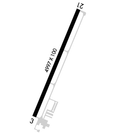
| Lat: N 4156.4 Long: W 08326.1 Elev: 616 Var: +05 Longest Runway: 4997 | ||
| AWOS: 119.07 CTAF: 122.7 | ||
| ||||||
| ||||||
|
| Rwy | Rwy | |||||||
| 4997x100 | 4997' | 4997x100 | 4997' | |||||
| Runway ID | Single Wheel | Double Wheel | Double Tandem Wheel | Dual Double Wheel |
| 03/21 | 60,000 | 80,000 | N/A | N/A |
| These numbers are Advisory and are not limits. The Airport Manager should have more accurate Weight Limits | ||||
 Airport Diagram might not be current. | |
| Facility Name: | CUSTER |
| City Name: | MONROE |
| County: | MONROE |
| State abbrev: | MI |
| State Name: | MICHIGAN |
| Ownership: | PUBLICLY OWNED |
| Use: | OPEN TO THE PUBLIC |
| Owner's Name: | CITY OF MONROE |
| Address: | 222 JONES AVE |
| MONROE, MI 48161 | |
| Owner's Phone: | (734) 384-9616 |
| Manager's Name: | JERARD E. DELANEY II. |
| Address: | 2800 N CUSTER RD |
| MONROE, MI 48161 | |
| Phone: | (734) 384-9616 |
| FAA Region: | GREAT LAKES |
| FAA Field Office: | DET |
| Date | Sunrise | Sunset |
|---|---|---|
| 09/24/21 Friday | 7:23 | 19:28 |
| 09/25/21 Saturday | 7:24 | 19:26 |
| 09/26/21 Sunday | 7:25 | 19:24 |
| 09/27/21 Monday | 7:26 | 19:23 |
| 09/28/21 Tuesday | 7:27 | 19:21 |
| 09/29/21 Wednesday | 7:28 | 19:19 |
| 09/30/21 Thursday | 7:29 | 19:17 |
| 10/01/21 Friday | 7:30 | 19:16 |
| 10/02/21 Saturday | 7:31 | 19:14 |
| 10/03/21 Sunday | 7:33 | 19:12 |
| 10/04/21 Monday | 7:34 | 19:11 |
| 10/05/21 Tuesday | 7:35 | 19:09 |
| 10/06/21 Wednesday | 7:36 | 19:07 |
| 10/07/21 Thursday | 7:37 | 19:06 |
| Airport Attendance Schedule | 7 Days A Week 0800-1700 |
| Airport Status | OPERATIONAL (This Status can change at any time - please check NOTAMS) |
| Airport Lighting Schedule | ACTVT MIRL RY 03/21, REIL RY 21, VASI RY 03 & PAPI RY 21 - CTAF. |
| Airport Storage Available | Tie Downs, Hanger |
| Extra Services Available | Charter, Flight Instruction, Aircraft Rental |
| Wind Indicator | YES - (lighted) |
| Control Tower | NO |
| CTAF Frequency | 122.700 |
| Unicom Frequency | 122.700 |
| Rotating Beacon Color | CLEAR-GREEN (Light Land Airport) |
| Segmented Circle | YES |
| Landing Fee | NO |
| Airport Inspected | STATE - performed by STATE AERONAUTICAL PERSONNEL |
| Inspection Date | 07/03/2018 |
| Type of Fuel Available | Grade 100LL, JET A (freeze point -40C) |
| Airframe Repair Service | MAJOR |
| Power Plant Repair Service | MAJOR |
| Latitude | N4156.4 |
| Longitude | W08326.1 (ESTIMATED) |
| Arpt Elevation | 615ft (SURVEYED) |
| Magnetic Variation | 05W |
| 2 miles NW | of MONROE |
| Traffic Pattern Altitude | |
| Sectional Chart | DETROIT |
| Operations (Reported) | Yearly | Avg. Daily |
|---|---|---|
| General Aviation Transient | 6000 | 16 |
| General Aviation Local | 6000 | 16 |
| Air Taxi | 0 | 0 |
| Commerical | 0 | 0 |
| Commuter | 0 | 0 |
| Military | 0 | 0 |
| Aircraft based on Field | |
|---|---|
| General Aviation Singles | 30 |
| General Aviation Multi | 4 |
| Jet Aircraft | 0 |
| General Aviation Helicopters | 0 |
| Military Aircraft | 0 |
| Gliders | 0 |
| Ultralights | 0 |
| FSS on field | NO |
| FSS tie-in | LANSING |
| FSS Phone | 1-800-WX-BRIEF |
| Who issues Notams | TTF |
| Notam D service at airport | YES |
| ARTCC Name | CLEVELAND |
| Airport Certification | |
| Aircraft Rescue & Firefighting Index | None |
| Airport of Entry | No |
| Custom Landing Rights | No |
| Joint Civil/Military | No |
| Military Landing rights | YES |
| NATIONAL PLAN OF INTEGRATED AIRPORT SYSTEMS (NPIAS) |
| GRANT AGREEMENTS UNDER FAAP/ADAP/AIP |
| SURPLUS PROPERTY AGREEMENT UNDER REGULATION 16-WAA |
| ASSURANCES PURSUANT TO TITLE VI, CIVIL RIGHTS ACT OF 1964 |
| THIS AIRPORT HAS BEEN SURVEYED BY THE NATIONAL GEODETIC SURVEY. |
| BIRDS & DEER INVOF RWY. |
| NOISE SENSITIVE AREAS. DEP ACFT MAX RATE OF CLIMB TO TPA. |
| FOR CD CTC DETROIT APCH AT 800-499-8181. |
Airport Communications & Frequencies:
| ||||||||||||||
| Runway: 03 | Runway: 21 | ||
| Mag heading: | 27° | Mag heading: | 207° |
| Rwy Slope: | .09% Up | Rwy Slope: | -.09% Down |
| Approach: | Approach: | ||
| Pattern: | Left Traffic | Pattern: | Left Traffic |
| Markings: | NONPRECISION INSTRUMENT | Markings: | NONPRECISION INSTRUMENT |
| Marking Condition: | FAIR | Marking Condition: | FAIR |
| Arresting Dev: | Arresting Dev: | ||
| Lat & Long: | N4156.0 W08326.3 | Lat. & Long.: | N4156.8 W08325.9 |
| Elev: | 611.1 ft. MSL | Elev: | 615.4 ft. MSL |
| TCH: | 58 ft. AGL | TCH: | 49 ft. AGL |
| Visual Glide Path: | 4.00 degrees | Visual Glide Path: | 3.50 degrees |
| Displaced Threshold: | No | Displaced Threshold: | No |
| Touchdown Zone: | YES | Touchdown Zone: | YES |
| Touchdown Elev.: | 614.2 feet | Touchdown Elev.: | 615.6 feet |
| Visual Glide Slope: | 2-Box VASI on LEFT side of Runway | Visual Glide Slope: | 2-Light PAPI on LEFT side of Runway |
| RVR Equipment: | RVR Equipment: | ||
| RVV Equipment: | NO | RVV Equipment: | NO |
| Approach Lights: | Approach Lights: | ||
| REIL: | NO | REIL: | YES |
| Centerline Lights: | NO | Centerline Lights: | NO |
| Touchdown lights: | NO | Touchdown lights: | NO |
| Runway Category: | Runway with a Non-precision Approach | Runway Category: | Runway with a Non-precision Approach |
| Declared Distances: | Declared Distances: | ||
| Obstructions: | TREES | Obstructions: | |
| Marked: | NOT Marked/Lighted | Marked: | |
| Clearance slope: | 25:1 | Clearance slope: | 34:1 |
| Obstruction height: | 64 feet AGL | Obstruction height: | |
| Dist. from runway: | 1800 feet | Dist. from runway: | |
| Centerline offset: | B | Centerline offset: | |
| Comments: | Comments: |
Thanks for using FltPlan.com
all rights reserved © 1999-2021 by Flight Plan LLC
