
| TRUCKEE-TAHOE TRUCKEE CA |
| |
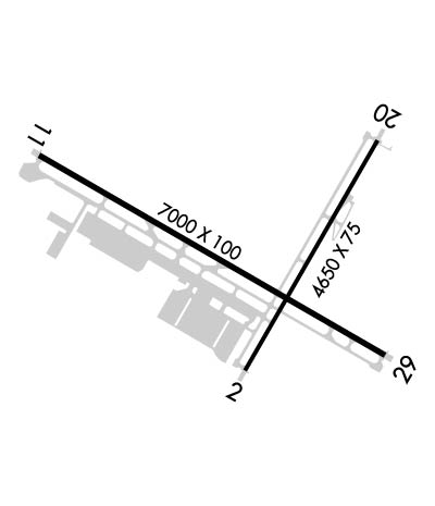
| Lat: N 3919.2 Long: W 12008.4 Elev: 5904 Var: -14 Longest Runway: 7001 | ||
| Dept. ATIS: 118.0 Arr. ATIS: 118.0 AWOS: 118.0 Ground: 118.3 Tower: 120.57 | ||
| ||||||||||||||||||||||||||||||||||||||||||||
| ||||||||||||||||||||||||||||||||||||||||||||
| ||||||||||||||||||||||||||||||||||||||||||||
| Rwy | Rwy | |||||||
| 4654x75 | 4654' | 4654x75 | 4539' | |||||
| 7001x100 | 7001' | 7001x100 | 7001' | |||||
| Runway ID | Single Wheel | Double Wheel | Double Tandem Wheel | Dual Double Wheel |
| 02/20 | 35,000 | 50,000 | N/A | N/A |
| 11/29 | 50,000 | 80,000 | N/A | N/A |
| These numbers are Advisory and are not limits. The Airport Manager should have more accurate Weight Limits | ||||
 Airport Diagram might not be current. | |
| Facility Name: | TRUCKEE-TAHOE |
| City Name: | TRUCKEE |
| County: | PLACER |
| State abbrev: | CA |
| State Name: | CALIFORNIA |
| Ownership: | PUBLICLY OWNED |
| Use: | OPEN TO THE PUBLIC |
| Owner's Name: | TRUCKEE-TAHOE AIRPORT DIST |
| Address: | 10356 TRUCKEE AIRPORT RD |
| TRUCKEE, CA 96161 | |
| Owner's Phone: | 530-587-4540 |
| Manager's Name: | ROBB ETNYRE |
| Address: | 10356 TRUCKEE AIRPORT RD |
| TRUCKEE, CA 96161 | |
| Phone: | 530-587-4119 |
| FAA Region: | WESTERN-PACIFIC |
| FAA Field Office: | SFO |

| Date | Sunrise | Sunset |
|---|---|---|
| 06/08/26 Monday | 5:34 | 20:26 |
| 06/09/26 Tuesday | 5:34 | 20:26 |
| 06/10/26 Wednesday | 5:33 | 20:27 |
| 06/11/26 Thursday | 5:33 | 20:27 |
| 06/12/26 Friday | 5:33 | 20:28 |
| 06/13/26 Saturday | 5:33 | 20:28 |
| 06/14/26 Sunday | 5:33 | 20:28 |
| 06/15/26 Monday | 5:33 | 20:29 |
| 06/16/26 Tuesday | 5:33 | 20:29 |
| 06/17/26 Wednesday | 5:33 | 20:30 |
| 06/18/26 Thursday | 5:33 | 20:30 |
| 06/19/26 Friday | 5:34 | 20:30 |
| 06/20/26 Saturday | 5:34 | 20:30 |
| 06/21/26 Sunday | 5:34 | 20:31 |
| Airport Attendance Schedule | NOV-FEB 7 Days A Week 0700-2000, MAR-OCT 7 Days A Week 0700-2100; ATNDNC HRS DRG PST. |
| Airport Status | OPERATIONAL (This Status can change at any time - please check NOTAMS) |
| Airport Lighting Schedule | WHEN ATCT CLSD ACTVT REIL RWY 11; MIRL RWY 2/20 & 11/29; VASI RWY 20 - CTAF. |
| Airport Storage Available | Tie Downs, Hanger |
| Extra Services Available | Charter, Glider, Flight Instruction, Aircraft Rental, Glider Towing |
| Wind Indicator | YES - (lighted) |
| Control Tower | YES |
| CTAF Frequency | 120.575; WHEN ATCT CLSD. |
| Unicom Frequency | 122.950 |
| Rotating Beacon Color | WG |
| Segmented Circle | YES |
| Landing Fee | YES |
| Airport Inspected | STATE - performed by STATE AERONAUTICAL PERSONNEL |
| Inspection Date | 08/01/2025 |
| Type of Fuel Available | Grade 100LL, JET A (freeze point -40C), JET A; -10MOBILE FUEL AVBL 0700-1900; SELF-SERVE AVBL 0700-2000.; -A JETA/SAF |
| Airframe Repair Service | MAJOR |
| Power Plant Repair Service | MINOR |
| Latitude | N3919.2 |
| Longitude | W12008.4 (ESTIMATED) |
| Arpt Elevation | 5904ft (SURVEYED) |
| Magnetic Variation | 14E |
| 2 miles E | of TRUCKEE |
| Traffic Pattern Altitude | 1100 |
| Sectional Chart | SAN FRANCISCO |
| Operations (Reported) | Yearly | Avg. Daily |
|---|---|---|
| General Aviation Transient | 0 | 0 |
| General Aviation Local | 0 | 0 |
| Air Taxi | 0 | 0 |
| Commerical | 0 | 0 |
| Commuter | 0 | 0 |
| Military | 0 | 0 |
| Aircraft based on Field | |
|---|---|
| General Aviation Singles | 0 |
| General Aviation Multi | 0 |
| Jet Aircraft | 0 |
| General Aviation Helicopters | 0 |
| Military Aircraft | 0 |
| Gliders | 0 |
| Ultralights | 0 |
| FSS on field | NO |
| FSS tie-in | RENO |
| FSS Phone | 1-800-WX-BRIEF |
| Who issues Notams | TRK |
| Notam D service at airport | YES |
| ARTCC Name | OAKLAND |
| Airport Certification | |
| Aircraft Rescue & Firefighting Index | None |
| Airport of Entry | No |
| Custom Landing Rights | No |
| Joint Civil/Military | No |
| Military Landing rights | YES |
| NATIONAL PLAN OF INTEGRATED AIRPORT SYSTEMS (NPIAS) |
| GRANT AGREEMENTS UNDER FAAP/ADAP/AIP |
| CONVEYANCE UNDER SCETION 16, FEDERAL AIRPORT ACT OF 1946 OR SECTION 23, AIRPORT AND AIRWAY DEVELOPMENT ACT OF 1970 |
| ASSURANCES PURSUANT TO TITLE VI, CIVIL RIGHTS ACT OF 1964 |
| RWY 20 & RWY 11 DIST-TO-GO MKRS INSTLD ON LEFT SIDE. |
| ACFT & HEL NOISE ABATEMENT RULES IN EFCT. PLS AVOID FLT OVER RESIDENTIAL AREAS, N, W, & S; CTC ARPT NOISE ABATEMENT OFC 530-587-4119 EXT 106 OR CHECK ARPT WEBSITE FOR COPY OF PROCS & RULES PRIOR TO ARR OR DEP. |
| NO DE-ICE SER AVAIL INDEF |
| SIMUL OPS ON RWYS 11/29 AND 2/20 MAY-SEP. |
| CLSD TO ULTRALIGHT ACT EXC BY PRIOR PMSN. |
| ACFT CPBL OF OPERG ABV 80,000 LBS MUST SMT CERTIF TO AMGR VFYG ACFT OPERG WT IS LESS THAN 80,000 LBS. |
| VOLUNTARY CURFEW: NO ENG STARTS ARR OR DEP EXC PPR OR LIFEGUARD/FIRE FIGHTING FLTS 2200-0700. |
| PREF CALM WIND RWY USE RWY 02. |
| NO ASR COVERAGE BLO 10,000 FT OVER KTRK |
| SPECIAL HAZARD: MOUNTAINOUS TRRN SRNDS ARPT AND RWYS; EXPC WINDSHEAR AND DOWNDRAFTS. |
| SUMMER DENSITY ALTS IN AFTNS FRQLY EXCEED 9000 FT. |
| COLD TEMPERATURE AIRPORT. ALTITUDE CORRECTION REQUIRED AT OR BELOW -17C. |
| WHEN ATCT CLSD, FOR CD CTC OAKLAND ARTCC AT 510-745-3380. |
| WILDLIFE ON AND INVOF ARPT. |
| GLDR OPNS NE OF ARPT MAY-SEP. |
Airport Communications & Frequencies:
| |||||||||||||||
| Runway: 02 | Runway: 20 | ||
| Mag heading: | 16° | Mag heading: | 196° |
| Rwy Slope: | .00% Up | Rwy Slope: | .00% Down |
| Approach: | Approach: | ||
| Pattern: | Left Traffic | Pattern: | Right Traffic; GLDRS USE LEFT TFC RWY 20. |
| Markings: | NONPRECISION INSTRUMENT | Markings: | NONPRECISION INSTRUMENT |
| Marking Condition: | GOOD | Marking Condition: | GOOD |
| Arresting Dev: | Arresting Dev: | ||
| Lat & Long: | N3918.9 W12008.4 | Lat. & Long.: | N3919.5 W12007.9 |
| Elev: | 5890.2 ft. MSL | Elev: | 5890.3 ft. MSL |
| TCH: | TCH: | 25 ft. AGL | |
| Visual Glide Path: | Visual Glide Path: | 3.50 degrees | |
| Displaced Threshold: | No | Displaced Threshold: | 115 feet |
| Touchdown Zone: | YES | Touchdown Zone: | YES |
| Touchdown Elev.: | 5897.8 feet | Touchdown Elev.: | 5897.8 feet |
| Visual Glide Slope: | Visual Glide Slope: | 2-Box VASI on LEFT side of Runway; UNUSBL BYD 2 DEGS LEFT OF CNTRLN. | |
| RVR Equipment: | RVR Equipment: | ||
| RVV Equipment: | NO | RVV Equipment: | NO |
| Approach Lights: | Approach Lights: | ||
| REIL: | NO | REIL: | NO |
| Centerline Lights: | NO | Centerline Lights: | NO |
| Touchdown lights: | NO | Touchdown lights: | NO |
| Runway Category: | Runway with a Visual Approach | Runway Category: | Runway with a Non-precision Approach |
| Declared Distances: | Declared Distances: |
| Runway: 11 | Runway: 29 | ||
| Mag heading: | 106° | Mag heading: | 286° |
| Rwy Slope: | -.12% Down | Rwy Slope: | .12% Up |
| Approach: | Approach: | ||
| Pattern: | Left Traffic | Pattern: | Left Traffic |
| Markings: | NONPRECISION INSTRUMENT | Markings: | NONPRECISION INSTRUMENT |
| Marking Condition: | GOOD | Marking Condition: | GOOD |
| Arresting Dev: | Arresting Dev: | ||
| Lat & Long: | N3919.5 W12009.2 | Lat. & Long.: | N3918.9 W12007.9 |
| Elev: | 5901.3 ft. MSL | Elev: | 5892.6 ft. MSL |
| TCH: | TCH: | ||
| Visual Glide Path: | Visual Glide Path: | ||
| Displaced Threshold: | No | Displaced Threshold: | No |
| Touchdown Zone: | YES | Touchdown Zone: | YES |
| Touchdown Elev.: | 5904.3 feet | Touchdown Elev.: | 5900.8 feet |
| Visual Glide Slope: | Visual Glide Slope: | ||
| RVR Equipment: | RVR Equipment: | ||
| RVV Equipment: | NO | RVV Equipment: | NO |
| Approach Lights: | Approach Lights: | ||
| REIL: | YES | REIL: | NO |
| Centerline Lights: | NO | Centerline Lights: | NO |
| Touchdown lights: | NO | Touchdown lights: | NO |
| Runway Category: | Runway with a Non-precision Approach having visibility minimums greater than 3/4 mile | Runway Category: | Runway with a Visual Approach |
| Declared Distances: | Declared Distances: |
Thanks for using FltPlan.com
all rights reserved © 1999-2026 by Flight Plan LLC