
| DRAUGHON-MILLER REGNL TEMPLE TX |
| |
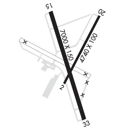
| Lat: N 3109.1 Long: W 09724.5 Elev: 682 Var: -03 Longest Runway: 7000 | ||
| Clr Del: 125.9 AWOS: 134.97 CTAF: 123.0 | ||
| ||||||
| ||||||
|
| Rwy | Rwy | |||||||
| 4740x100 | 4740' | 4740x100 | 4740' | |||||
| 7000x150 | 7000' | 111.50 - 159° | 7000x150 | 7000' | ||||
| Runway ID | Single Wheel | Double Wheel | Double Tandem Wheel | Dual Double Wheel |
| 02/20 | 31,000 | 37,000 | N/A | N/A |
| 15/33 | 55,000 | 70,000 | 110,000 | N/A |
| These numbers are Advisory and are not limits. The Airport Manager should have more accurate Weight Limits | ||||
 Airport Diagram might not be current. | |
| Facility Name: | DRAUGHON-MILLER CENTRAL TEXAS RGNL |
| City Name: | TEMPLE |
| County: | BELL |
| State abbrev: | TX |
| State Name: | TEXAS |
| Ownership: | PUBLICLY OWNED |
| Use: | OPEN TO THE PUBLIC |
| Owner's Name: | CITY OF TEMPLE |
| Address: | 2 N. MAIN |
| TEMPLE, TX 76501 | |
| Owner's Phone: | 254-298-5660 |
| Manager's Name: | SEAN PARKER |
| Address: | 7720-F AIRPORT ROAD |
| TEMPLE, TX 76501 | |
| Phone: | 254-298-5350 |
| FAA Region: | SOUTHWEST |
| FAA Field Office: | TEX |
| Date | Sunrise | Sunset |
|---|---|---|
| 09/24/21 Friday | 7:19 | 19:24 |
| 09/25/21 Saturday | 7:20 | 19:23 |
| 09/26/21 Sunday | 7:20 | 19:21 |
| 09/27/21 Monday | 7:21 | 19:20 |
| 09/28/21 Tuesday | 7:21 | 19:19 |
| 09/29/21 Wednesday | 7:22 | 19:18 |
| 09/30/21 Thursday | 7:23 | 19:16 |
| 10/01/21 Friday | 7:23 | 19:15 |
| 10/02/21 Saturday | 7:24 | 19:14 |
| 10/03/21 Sunday | 7:24 | 19:12 |
| 10/04/21 Monday | 7:25 | 19:11 |
| 10/05/21 Tuesday | 7:26 | 19:10 |
| 10/06/21 Wednesday | 7:26 | 19:09 |
| 10/07/21 Thursday | 7:27 | 19:08 |
| Airport Attendance Schedule | 7 Days A Week 0500-2200 |
| Airport Status | OPERATIONAL (This Status can change at any time - please check NOTAMS) |
| Airport Lighting Schedule | DUSK-2200. ACTVT PAPI RY 20 - CTAF. AFT 2200 MIRL RY 15/33 PRESET LOW INTST; TO INCR INTST & ACTVT MALSR RY 15 - CTAF. MIRL RY 02/20 NOT AVBL AFT 2200. |
| Airport Storage Available | Tie Downs |
| Extra Services Available | Avionics, Flight Instruction, Parachute Jumping, Aircraft Rental |
| Wind Indicator | YES - (lighted) |
| Control Tower | NO |
| CTAF Frequency | 123.000 |
| Unicom Frequency | 123.000 |
| Rotating Beacon Color | CLEAR-GREEN (Light Land Airport) |
| Segmented Circle | YES |
| Landing Fee | NO |
| Airport Inspected | FEDERAL - performed by PRIVATE CONTRACT PERSONNEL |
| Inspection Date | 04/17/2019 |
| Type of Fuel Available | Grade 100LL, JET A (freeze point -40C), JET A-1 (icing inhibitor, freeze point -50C) |
| Airframe Repair Service | MAJOR |
| Power Plant Repair Service | MAJOR |
| Latitude | N3109.1 |
| Longitude | W09724.5 (ESTIMATED) |
| Arpt Elevation | 682ft (SURVEYED) |
| Magnetic Variation | 03E |
| 5 miles NW | of TEMPLE |
| Traffic Pattern Altitude | |
| Sectional Chart | SAN ANTONIO |
| Operations (Reported) | Yearly | Avg. Daily |
|---|---|---|
| General Aviation Transient | 8400 | 23 |
| General Aviation Local | 25200 | 69 |
| Air Taxi | 0 | 0 |
| Commerical | 0 | 0 |
| Commuter | 0 | 0 |
| Military | 7524 | 21 |
| Aircraft based on Field | |
|---|---|
| General Aviation Singles | 76 |
| General Aviation Multi | 5 |
| Jet Aircraft | 8 |
| General Aviation Helicopters | 7 |
| Military Aircraft | 147 |
| Gliders | 1 |
| Ultralights | 0 |
| FSS on field | NO |
| FSS tie-in | SAN ANGELO |
| FSS Phone | 1-800-WX-BRIEF |
| Who issues Notams | TPL |
| Notam D service at airport | YES |
| ARTCC Name | HOUSTON |
| Airport Certification | ARFF PROTECTION MEETS INDEX B. |
| Aircraft Rescue & Firefighting Index | ARFF NOT AVBL 2200-0500. |
| Airport of Entry | No |
| Custom Landing Rights | No |
| Joint Civil/Military | No |
| Military Landing rights | YES |
| NATIONAL PLAN OF INTEGRATED AIRPORT SYSTEMS (NPIAS) |
| GRANT AGREEMENTS UNDER FAAP/ADAP/AIP |
| SURPLUS PROPERTY AGREEMENT UNDER PUBLIC LAW 289 |
| SURPLUS PROPERTY AGREEMENT UNDER REGULATION 16-WAA |
| ASSURANCES PURSUANT TO TITLE VI, CIVIL RIGHTS ACT OF 1964 |
| AGREEMENT UNDER DLAND OR DCLA HAS EXPIRED. |
| ARFF NOT AVBL 2200-0500. |
| MILITARY CONTRACT FUEL AVBL. |
| GLIDER OPERATION 1.5 MILES NORTH OF RY 15 THLD. |
| PAEW ADJ ALL TWYS & RWYS . |
Airport Communications & Frequencies:
| ||||||||||||||||
| Runway: 02 | Runway: 20 | ||
| Mag heading: | 25° | Mag heading: | 205° |
| Rwy Slope: | -.20% Down | Rwy Slope: | .20% Up |
| Approach: | Approach: | ||
| Pattern: | Left Traffic | Pattern: | Left Traffic |
| Markings: | BASIC | Markings: | BASIC |
| Marking Condition: | GOOD | Marking Condition: | GOOD |
| Arresting Dev: | Arresting Dev: | ||
| Lat & Long: | N3108.9 W09724.6 | Lat. & Long.: | N3109.6 W09724.1 |
| Elev: | 674.4 ft. MSL | Elev: | 665.1 ft. MSL |
| TCH: | TCH: | 47 ft. AGL | |
| Visual Glide Path: | Visual Glide Path: | 3.00 degrees | |
| Displaced Threshold: | No | Displaced Threshold: | No |
| Touchdown Zone: | YES | Touchdown Zone: | YES |
| Touchdown Elev.: | 674.9 feet | Touchdown Elev.: | 668.5 feet |
| Visual Glide Slope: | Visual Glide Slope: | 4-Light PAPI on LEFT side of Runway | |
| RVR Equipment: | RVR Equipment: | ||
| RVV Equipment: | NO | RVV Equipment: | NO |
| Approach Lights: | Approach Lights: | ||
| REIL: | NO | REIL: | NO |
| Centerline Lights: | NO | Centerline Lights: | NO |
| Touchdown lights: | NO | Touchdown lights: | NO |
| Runway Category: | Runway with a Non-precision Approach having visibility minimums greater than 3/4 mile | Runway Category: | Runway with a Visual Approach |
| Declared Distances: | TORA:4740' TODA:4740' ASDA:4740' LDA:4740' | Declared Distances: | TORA:4740' TODA:4740' ASDA:4740' LDA:4740' |
| Obstructions: | Obstructions: | TREES | |
| Marked: | Marked: | NOT Marked/Lighted | |
| Clearance slope: | 50:1 | Clearance slope: | 34:1 |
| Obstruction height: | Obstruction height: | 33 feet AGL | |
| Dist. from runway: | Dist. from runway: | 1350 feet | |
| Centerline offset: | Centerline offset: | 220 feet right of centerline | |
| Comments: | Comments: |
| Runway: 15 | Runway: 33 | ||
| Mag heading: | 160° | Mag heading: | 340° |
| Rwy Slope: | -.19% Down | Rwy Slope: | .19% Up |
| Approach: | ILS/DME | Approach: | |
| Pattern: | Left Traffic | Pattern: | Left Traffic |
| Markings: | PRECISION INSTRUMENT | Markings: | PRECISION INSTRUMENT |
| Marking Condition: | GOOD | Marking Condition: | GOOD |
| Arresting Dev: | Arresting Dev: | ||
| Lat & Long: | N3109.6 W09724.7 | Lat. & Long.: | N3108.5 W09724.3 |
| Elev: | 682.3 ft. MSL | Elev: | 669.0 ft. MSL |
| TCH: | TCH: | 34 ft. AGL | |
| Visual Glide Path: | Visual Glide Path: | 3.00 degrees | |
| Displaced Threshold: | No | Displaced Threshold: | No |
| Touchdown Zone: | YES | Touchdown Zone: | YES |
| Touchdown Elev.: | 682.3 feet | Touchdown Elev.: | 674.0 feet |
| Visual Glide Slope: | Visual Glide Slope: | 4-Light PAPI on LEFT side of Runway | |
| RVR Equipment: | RVR Equipment: | ||
| RVV Equipment: | NO | RVV Equipment: | NO |
| Approach Lights: | MALSR - 1,400 foot medium intensity approach lighting system with runway alignment indicator lights | Approach Lights: | |
| REIL: | NO | REIL: | NO |
| Centerline Lights: | NO | Centerline Lights: | NO |
| Touchdown lights: | NO | Touchdown lights: | NO |
| Runway Category: | Precision Instrument Runway | Runway Category: | D |
| Declared Distances: | TORA:6301' TODA:6301' ASDA:6301' LDA:6301' | Declared Distances: | TORA:6301' TODA:6301' ASDA:6301' LDA:6301' |
Thanks for using FltPlan.com
all rights reserved © 1999-2021 by Flight Plan LLC