
| TONOPAH TONOPAH NV |
| |
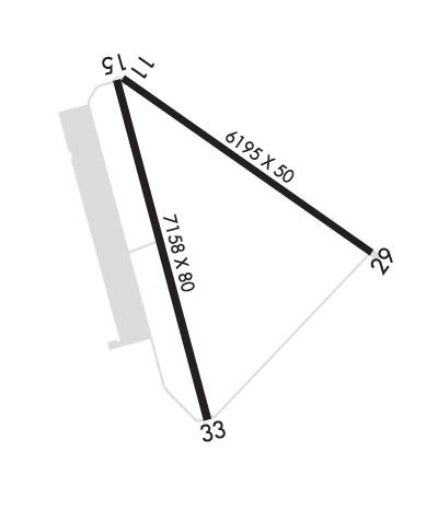
| Lat: N 3803.6 Long: W 11705.2 Elev: 5430 Var: -15 Longest Runway: 7160 | ||
| AWOS: 118.87 CTAF: 123.0 | ||
| ||||||
| ||||||
|
| Rwy | Rwy | |||||||
| 5660x50 | 5660' | 5660x50 | 5660' | |||||
| 7160x75 | 7160' | 7160x75 | 7160' | |||||
| Runway ID | Single Wheel | Double Wheel | Double Tandem Wheel | Dual Double Wheel |
| 11/29 | 30,000 | 66,000 | 77,000 | N/A |
| 15/33 | 30,000 | N/A | N/A | N/A |
| H1 | N/A | N/A | N/A | N/A |
| These numbers are Advisory and are not limits. The Airport Manager should have more accurate Weight Limits | ||||
 Airport Diagram might not be current. | |
| Facility Name: | TONOPAH |
| City Name: | TONOPAH |
| County: | NYE |
| State abbrev: | NV |
| State Name: | NEVADA |
| Ownership: | PUBLICLY OWNED |
| Use: | OPEN TO THE PUBLIC |
| Owner's Name: | NYE COUNTY; EMERG CTC 775-513-3107. |
| Address: | P O BOX 1031 |
| TONOPAH, NV 89049 | |
| Owner's Phone: | (775) 209-4174; OTR CTC (775) 482-3626. |
| Manager's Name: | THOMAS BOLLING |
| Address: | PUBLIC WORKS, 250 N. HWY 160 #2 |
| PAHRUMP, NV 89060 | |
| Phone: | (775) 751-6262 |
| FAA Region: | WESTERN-PACIFIC |
| FAA Field Office: | PHX |
| Date | Sunrise | Sunset |
|---|---|---|
| 09/24/21 Friday | 6:38 | 18:42 |
| 09/25/21 Saturday | 6:39 | 18:41 |
| 09/26/21 Sunday | 6:39 | 18:39 |
| 09/27/21 Monday | 6:40 | 18:38 |
| 09/28/21 Tuesday | 6:41 | 18:36 |
| 09/29/21 Wednesday | 6:42 | 18:35 |
| 09/30/21 Thursday | 6:43 | 18:33 |
| 10/01/21 Friday | 6:44 | 18:32 |
| 10/02/21 Saturday | 6:45 | 18:30 |
| 10/03/21 Sunday | 6:46 | 18:28 |
| 10/04/21 Monday | 6:47 | 18:27 |
| 10/05/21 Tuesday | 6:47 | 18:25 |
| 10/06/21 Wednesday | 6:48 | 18:24 |
| 10/07/21 Thursday | 6:49 | 18:22 |
| Airport Attendance Schedule | 7 Days A Week 0600-2300 |
| Airport Status | OPERATIONAL (This Status can change at any time - please check NOTAMS) |
| Airport Lighting Schedule | ACTVT PAPI RWY 15; MIRL RWY 15/33 & 11/29 - CTAF. |
| Airport Storage Available | Tie Downs, Buoys |
| Extra Services Available | Air Ambulance |
| Wind Indicator | YES - (lighted) |
| Control Tower | NO |
| CTAF Frequency | 123.000 |
| Unicom Frequency | 123.000 |
| Rotating Beacon Color | CLEAR-GREEN (Light Land Airport) |
| Segmented Circle | YES |
| Landing Fee | NO |
| Airport Inspected | STATE - performed by STATE AERONAUTICAL PERSONNEL |
| Inspection Date | 05/30/2019 |
| Type of Fuel Available | Grade 100LL, JET A (freeze point -40C); -10FUEL AVBL 0700-1800; AFT HRS O/R CALL (775) 482-3626. |
| Airframe Repair Service | MAJOR |
| Power Plant Repair Service | MAJOR |
| Latitude | N3803.6 |
| Longitude | W11705.2 (ESTIMATED) |
| Arpt Elevation | 5430ft (SURVEYED) |
| Magnetic Variation | 15E |
| 7 miles E | of TONOPAH |
| Traffic Pattern Altitude | |
| Sectional Chart | LAS VEGAS |
| Operations (Reported) | Yearly | Avg. Daily |
|---|---|---|
| General Aviation Transient | 3650 | 10 |
| General Aviation Local | 1080 | 3 |
| Air Taxi | 1825 | 5 |
| Commerical | 0 | 0 |
| Commuter | 0 | 0 |
| Military | 320 | 1 |
| Aircraft based on Field | |
|---|---|
| General Aviation Singles | 7 |
| General Aviation Multi | 1 |
| Jet Aircraft | 0 |
| General Aviation Helicopters | 1 |
| Military Aircraft | 0 |
| Gliders | 0 |
| Ultralights | 0 |
| FSS on field | NO |
| FSS tie-in | RENO |
| FSS Phone | 1-800-WX-BRIEF |
| Who issues Notams | TPH |
| Notam D service at airport | YES |
| ARTCC Name | LOS ANGELES |
| Airport Certification | |
| Aircraft Rescue & Firefighting Index | None |
| Airport of Entry | No |
| Custom Landing Rights | No |
| Joint Civil/Military | No |
| Military Landing rights | YES |
| NATIONAL PLAN OF INTEGRATED AIRPORT SYSTEMS (NPIAS) |
| GRANT AGREEMENTS UNDER FAAP/ADAP/AIP |
| SURPLUS PROPERTY AGREEMENT UNDER PUBLIC LAW 289 |
| ASSURANCES PURSUANT TO TITLE VI, CIVIL RIGHTS ACT OF 1964 |
| FOR CD IF UNA TO CTC ON FSS FREQ, CTC LOS ANGELES ARTCC AT 661-575-2079. |
| RWY 11/2 9 RWY CRACKING FULL-LEN; LATERAL & LONGL CRACKS IN EXCESS OF 4 INCHES. |
Airport Communications & Frequencies:
|
| Runway: 11 | Runway: 29 | ||
| Mag heading: | 110° | Mag heading: | 290° |
| Rwy Slope: | -.32% Down | Rwy Slope: | .32% Up |
| Approach: | Approach: | ||
| Pattern: | Left Traffic | Pattern: | Left Traffic |
| Markings: | BASIC | Markings: | BASIC |
| Marking Condition: | FAIR | Marking Condition: | FAIR |
| Arresting Dev: | Arresting Dev: | ||
| Lat & Long: | N3804.0 W11705.5 | Lat. & Long.: | N3803.5 W11704.5 |
| Elev: | 5428.4 ft. MSL | Elev: | 5410.4 ft. MSL |
| TCH: | TCH: | ||
| Visual Glide Path: | Visual Glide Path: | ||
| Displaced Threshold: | No | Displaced Threshold: | No |
| Touchdown Zone: | YES | Touchdown Zone: | YES |
| Touchdown Elev.: | 5428.4 feet | Touchdown Elev.: | 5421.2 feet |
| Visual Glide Slope: | Visual Glide Slope: | ||
| RVR Equipment: | RVR Equipment: | ||
| RVV Equipment: | NO | RVV Equipment: | NO |
| Approach Lights: | Approach Lights: | ||
| REIL: | NO | REIL: | NO |
| Centerline Lights: | NO | Centerline Lights: | NO |
| Touchdown lights: | NO | Touchdown lights: | NO |
| Runway Category: | Runway with a Visual Approach | Runway Category: | Runway with a Visual Approach |
| Declared Distances: | Declared Distances: |
| Runway: 15 | Runway: 33 | ||
| Mag heading: | 150° | Mag heading: | 330° |
| Rwy Slope: | -.48% Down | Rwy Slope: | .48% Up |
| Approach: | Approach: | ||
| Pattern: | Left Traffic | Pattern: | Left Traffic |
| Markings: | NONPRECISION INSTRUMENT | Markings: | NONPRECISION INSTRUMENT |
| Marking Condition: | GOOD | Marking Condition: | GOOD |
| Arresting Dev: | Arresting Dev: | ||
| Lat & Long: | N3804.1 W11705.6 | Lat. & Long.: | N3802.9 W11705.2 |
| Elev: | 5430.2 ft. MSL | Elev: | 5396.0 ft. MSL |
| TCH: | 41 ft. AGL | TCH: | |
| Visual Glide Path: | 3.00 degrees | Visual Glide Path: | |
| Displaced Threshold: | No | Displaced Threshold: | No |
| Touchdown Zone: | YES | Touchdown Zone: | YES |
| Touchdown Elev.: | 5430.3 feet | Touchdown Elev.: | 5410.6 feet |
| Visual Glide Slope: | 2-Light PAPI on LEFT side of Runway | Visual Glide Slope: | |
| RVR Equipment: | RVR Equipment: | ||
| RVV Equipment: | NO | RVV Equipment: | NO |
| Approach Lights: | Approach Lights: | ||
| REIL: | NO | REIL: | NO |
| Centerline Lights: | NO | Centerline Lights: | NO |
| Touchdown lights: | NO | Touchdown lights: | NO |
| Runway Category: | Runway with a Non-precision Approach | Runway Category: | Runway with a Visual Approach |
| Declared Distances: | Declared Distances: |
Thanks for using FltPlan.com
all rights reserved © 1999-2021 by Flight Plan LLC
