
| TONOPAH TEST RANGE (PVT) TONOPAH NV |
| |
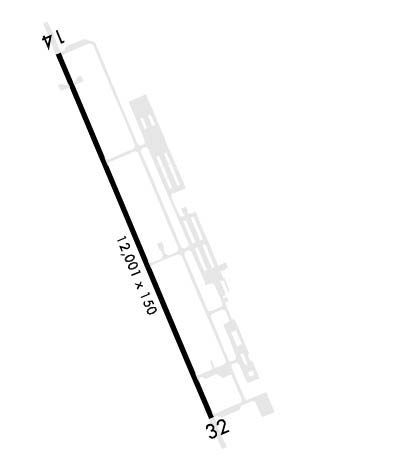
| Lat: N 3747.9 Long: W 11646.8 Elev: 5550 Var: -16 Longest Runway: 12001 | ||
| Ground: 127.25 Tower: 124.75 | ||
| |||||
|
| Rwy | Rwy | |||||||
| 12001x150 | 12001' | 108.30 - 141° | 12001x150 | 12001' | 111.70 - 321° | |||
| Runway ID | Single Wheel | Double Wheel | Double Tandem Wheel | Dual Double Wheel |
| 15/33 | N/A | N/A | N/A | N/A |
| These numbers are Advisory and are not limits. The Airport Manager should have more accurate Weight Limits | ||||
 Airport Diagram might not be current. | |
| Facility Name: | TONOPAH TEST RANGE |
| City Name: | TONOPAH |
| County: | NYE |
| State abbrev: | NV |
| State Name: | NEVADA |
| Ownership: | AIR FORCE OWNED |
| Use: | PRIVATE |
| Owner's Name: | US AIR FORCE |
| Address: | HQ AIR COMBAT COMMAND |
| LANGLEY AFB, VA 23665 | |
| Owner's Phone: | 804-764-3120 |
| Manager's Name: | VERNON GABBARD JR |
| Address: | SANDIA LAB PO BOX 871 |
| TONOPAH, NV 89049 | |
| Phone: | 702-295-8313 |
| FAA Region: | WESTERN-PACIFIC |
| FAA Field Office: | PHX |
| Date | Sunrise | Sunset |
|---|---|---|
| 06/12/26 Friday | 5:25 | 20:09 |
| 06/13/26 Saturday | 5:24 | 20:10 |
| 06/14/26 Sunday | 5:24 | 20:10 |
| 06/15/26 Monday | 5:25 | 20:11 |
| 06/16/26 Tuesday | 5:25 | 20:11 |
| 06/17/26 Wednesday | 5:25 | 20:11 |
| 06/18/26 Thursday | 5:25 | 20:12 |
| 06/19/26 Friday | 5:25 | 20:12 |
| 06/20/26 Saturday | 5:25 | 20:12 |
| 06/21/26 Sunday | 5:25 | 20:12 |
| 06/22/26 Monday | 5:26 | 20:13 |
| 06/23/26 Tuesday | 5:26 | 20:13 |
| 06/24/26 Wednesday | 5:26 | 20:13 |
| 06/25/26 Thursday | 5:26 | 20:13 |
| Airport Attendance Schedule | ALL; 1300Z++ MON - 0305Z++ FRI; CLSD WKEND & HOL; OTR TIMES BY NOTAM. |
| Airport Status | OPERATIONAL (This Status can change at any time - please check NOTAMS) |
| Airport Lighting Schedule | ACTVT ALSF-1 RWY 15 & 33; PAPI RWY 15 & 33; HIRL RWY 15/33 - 257.95. ALSF-1 RWY 15 & 33 HI INTST ONLY. |
| Airport Storage Available | NONE |
| Extra Services Available | NONE |
| Wind Indicator | YES - (unlit) |
| Control Tower | YES |
| CTAF Frequency | |
| Unicom Frequency | |
| Rotating Beacon Color | |
| Segmented Circle | YES |
| Landing Fee | NO |
| Airport Inspected | No Inspection Data Available performed by the OWNER |
| Inspection Date | 12/14/1983 |
| Type of Fuel Available | ++ |
| Airframe Repair Service | NONE |
| Power Plant Repair Service | NONE |
| Latitude | N3747.9 |
| Longitude | W11646.8 (ESTIMATED) |
| Arpt Elevation | 5550ft (SURVEYED) |
| Magnetic Variation | 16E |
| 27 miles SE | of TONOPAH |
| Traffic Pattern Altitude | RECTANGULAR 7000 FT MSL 1500 FT AGL; OVHD 7500 FT MSL 2000 FT AGL. |
| Sectional Chart | LAS VEGAS |
| Operations (Reported) | Yearly | Avg. Daily |
|---|---|---|
| General Aviation Transient | 0 | 0 |
| General Aviation Local | 0 | 0 |
| Air Taxi | 0 | 0 |
| Commerical | 0 | 0 |
| Commuter | 0 | 0 |
| Military | 0 | 0 |
| Aircraft based on Field | |
|---|---|
| General Aviation Singles | 0 |
| General Aviation Multi | 0 |
| Jet Aircraft | 0 |
| General Aviation Helicopters | 0 |
| Military Aircraft | 0 |
| Gliders | 0 |
| Ultralights | 0 |
| FSS on field | NO |
| FSS tie-in | RENO |
| FSS Phone | 1-800-WX-BRIEF |
| Who issues Notams | RNO |
| Notam D service at airport | YES |
| ARTCC Name | LOS ANGELES |
| Airport Certification | |
| Aircraft Rescue & Firefighting Index | None |
| Airport of Entry | No |
| Custom Landing Rights | No |
| Joint Civil/Military | No |
| Military Landing rights | No |
| RSTRD: AFLD LCTD WITHIN R4809; CTC 98 RANGE WING/XPR D348-5537/C702-653-5537; 72 HR PPR - AFLD OPS D384-5937/C702-653-5937. |
| MISC: NO CLASSIFIED MTRL STORAGE. |
| CTN: HI PER MIL OPS R4809A. |
| BASH MIGRATORY BIRD ACT OCT- MAR PHASE II. |
| RSTRD: DOWNWARD THRUST JET BLAST RSTD FM FULL PWR FIRST 500 FT RWY 15 & 33. |
| MISC: AD VER TKOF/LDG NA. |
| PPR - COORD THRU POC/SPONSOR. |
| WX BRIEF AFT OPS HRS - 25 OWS DAVIS MONTHAN AFB D228-6598/6599/C520-228-6598/6599. |
| RSTD: DELTA RAMP SFC MARKING NSTD. |
| RSTD: ALL TRAN ACFT MUST OBTAIN PPR PRIOR TO ARR. ACFT MUST ADHERE TO PPR ARR BLOCK +/- 30 MIN OF SKED LDG. |
| JASU-3 (AM32A-60A). |
| FLUID-DE-ICE. |
| OIL- O-148. |
| TRAN ALERT: 1300-0300Z++ WKDAY; CLSD WKEND & HOL; FLEET SVC & MAINT UNAVBL. |
Airport Communications & Frequencies:
| ||||||||||
| Runway: 15 | Runway: 33 | ||
| Mag heading: | 141° | Mag heading: | 321° |
| Rwy Slope: | .64% Up | Rwy Slope: | -.64% Down |
| Approach: | LOC/GS | Approach: | LOC/GS |
| Pattern: | Left Traffic | Pattern: | Left Traffic |
| Markings: | Markings: | ||
| Marking Condition: | Marking Condition: | ||
| Arresting Dev: | BAK-12B,BAK-14; BAK-14 BAK-12B(B) (1500 FT). | Arresting Dev: | BAK-12B,BAK-14; BAK-14 BAK-12B(B) (1600 FT). |
| Lat & Long: | N3748.8 W11647.3 | Lat. & Long.: | N3747.0 W11646.4 |
| Elev: | 5473.4 ft. MSL | Elev: | 5550.3 ft. MSL |
| TCH: | 51 ft. AGL | TCH: | 39 ft. AGL |
| Visual Glide Path: | 2.75 degrees | Visual Glide Path: | 2.75 degrees |
| Displaced Threshold: | No | Displaced Threshold: | No |
| Touchdown Zone: | YES | Touchdown Zone: | YES |
| Touchdown Elev.: | 5496.3 feet | Touchdown Elev.: | 5550.3 feet |
| Visual Glide Slope: | 4-Light PAPI on LEFT side of Runway | Visual Glide Slope: | 4-Light PAPI on LEFT side of Runway |
| RVR Equipment: | RVR Equipment: | ||
| RVV Equipment: | NO | RVV Equipment: | NO |
| Approach Lights: | ALSF1 - standard 2,400 foot high intensity approach lighting system with sequenced flashers, Category I | Approach Lights: | ALSF1 - standard 2,400 foot high intensity approach lighting system with sequenced flashers, Category I |
| REIL: | NO | REIL: | NO |
| Centerline Lights: | NO | Centerline Lights: | NO |
| Touchdown lights: | NO | Touchdown lights: | NO |
| Runway Category: | Runway Category: | ||
| Declared Distances: | Declared Distances: |
Thanks for using FltPlan.com
all rights reserved © 1999-2026 by Flight Plan LLC
