| HENRY TIFT MYERS TIFTON GA |
| |
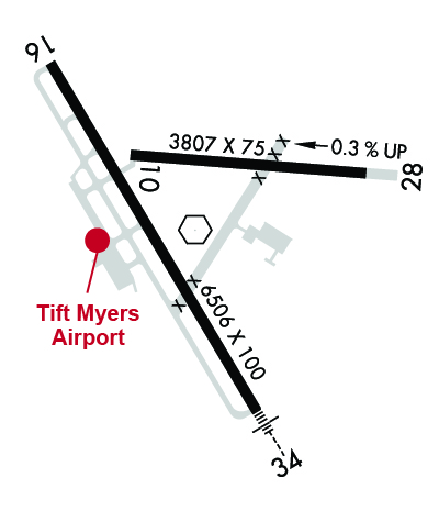
| Lat: N 3125.8 Long: W 08329.4 Elev: 355 Var: +03 Longest Runway: 6506 | ||
| AWOS: 118.52 CTAF: 122.7 | ||
| |||||||||||||||||||||||
| |||||||||||||||||||||||
| |||||||||||||||||||||||
| Rwy | Rwy | |||||||
| 3807x75 | 3807' | 3807x75 | 3807' | |||||
| 6506x100 | 6506' | 6506x100 | 6506' | 109.70 - 332° | ||||
| Runway ID | Single Wheel | Double Wheel | Double Tandem Wheel | Dual Double Wheel |
| 10/28 | 30,000 | 45,000 | 75,000 | N/A |
| 16/34 | 42,000 | 60,000 | 106,000 | N/A |
| These numbers are Advisory and are not limits. The Airport Manager should have more accurate Weight Limits | ||||
 Airport Diagram might not be current. | |
| Facility Name: | HENRY TIFT MYERS |
| City Name: | TIFTON |
| County: | TIFT |
| State abbrev: | GA |
| State Name: | GEORGIA |
| Ownership: | PUBLICLY OWNED |
| Use: | OPEN TO THE PUBLIC |
| Owner's Name: | TIFTON & TIFT CO ARPT AUTH. |
| Address: | PO BOX 826 |
| TIFTON, GA 31793 | |
| Owner's Phone: | 229-391-3535 |
| Manager's Name: | CLARK WALKER |
| Address: | 3093 US HIGHWAY 41 S |
| TIFTON, GA 31794 | |
| Phone: | 229-382-2545 |
| FAA Region: | SOUTHERN |
| FAA Field Office: | ATL |
| Date | Sunrise | Sunset |
|---|---|---|
| 09/24/21 Friday | 7:23 | 19:28 |
| 09/25/21 Saturday | 7:24 | 19:27 |
| 09/26/21 Sunday | 7:24 | 19:26 |
| 09/27/21 Monday | 7:25 | 19:24 |
| 09/28/21 Tuesday | 7:26 | 19:23 |
| 09/29/21 Wednesday | 7:26 | 19:22 |
| 09/30/21 Thursday | 7:27 | 19:21 |
| 10/01/21 Friday | 7:28 | 19:19 |
| 10/02/21 Saturday | 7:28 | 19:18 |
| 10/03/21 Sunday | 7:29 | 19:17 |
| 10/04/21 Monday | 7:29 | 19:15 |
| 10/05/21 Tuesday | 7:30 | 19:14 |
| 10/06/21 Wednesday | 7:31 | 19:13 |
| 10/07/21 Thursday | 7:31 | 19:12 |
| Airport Attendance Schedule | MON-FRI 0700-1800, SAT-SUN 0800-1800; AFTER HRS SVC: 229-382-2545. |
| Airport Status | OPERATIONAL (This Status can change at any time - please check NOTAMS) |
| Airport Lighting Schedule | ACTVT HIRL RWY 16/34, PAPI RWYS 16 AND 34, MALSR RWY 34 - CTAF. |
| Airport Storage Available | Tie Downs |
| Extra Services Available | Flight Instruction |
| Wind Indicator | YES - (lighted) |
| Control Tower | NO |
| CTAF Frequency | 122.700 |
| Unicom Frequency | 122.700 |
| Rotating Beacon Color | CLEAR-GREEN (Light Land Airport) |
| Segmented Circle | YES |
| Landing Fee | NO |
| Airport Inspected | STATE - performed by STATE AERONAUTICAL PERSONNEL |
| Inspection Date | 01/16/2020 |
| Type of Fuel Available | Grade 100LL, JET A; -10FUEL 24 HR CREDIT CARD SVC AVBL. |
| Airframe Repair Service | MAJOR |
| Power Plant Repair Service | MAJOR |
| Latitude | N3125.8 |
| Longitude | W08329.4 (ESTIMATED) |
| Arpt Elevation | 354ft (SURVEYED) |
| Magnetic Variation | 03W |
| 2 miles SE | of TIFTON |
| Traffic Pattern Altitude | |
| Sectional Chart | JACKSONVILLE |
| Operations (Reported) | Yearly | Avg. Daily |
|---|---|---|
| General Aviation Transient | 5000 | 14 |
| General Aviation Local | 13500 | 37 |
| Air Taxi | 0 | 0 |
| Commerical | 0 | 0 |
| Commuter | 0 | 0 |
| Military | 200 | 1 |
| Aircraft based on Field | |
|---|---|
| General Aviation Singles | 11 |
| General Aviation Multi | 12 |
| Jet Aircraft | 1 |
| General Aviation Helicopters | 0 |
| Military Aircraft | 0 |
| Gliders | 0 |
| Ultralights | 0 |
| FSS on field | NO |
| FSS tie-in | MACON |
| FSS Phone | 1-800-WX-BRIEF |
| Who issues Notams | MCN |
| Notam D service at airport | YES |
| ARTCC Name | JACKSONVILLE |
| Airport Certification | |
| Aircraft Rescue & Firefighting Index | None |
| Airport of Entry | No |
| Custom Landing Rights | No |
| Joint Civil/Military | No |
| Military Landing rights | YES |
| NATIONAL PLAN OF INTEGRATED AIRPORT SYSTEMS (NPIAS) |
| GRANT AGREEMENTS UNDER FAAP/ADAP/AIP |
| SURPLUS PROPERTY AGREEMENT UNDER REGULATION 16-WAA |
| ASSURANCES PURSUANT TO TITLE VI, CIVIL RIGHTS ACT OF 1964 |
| AGREEMENT UNDER DLAND OR DCLA HAS EXPIRED. |
| (E99) USED FOR MAINT. |
| (CONTACT TITLE) CHAIRMAN HENRY TIFT MYERS AIRPORT AUTHORITY. |
Airport Communications & Frequencies:
| |||||||||||||||||||||
| Runway: 10 | Runway: 28 | ||
| Mag heading: | 97° | Mag heading: | 277° |
| Rwy Slope: | -.32% Down | Rwy Slope: | .32% Up |
| Approach: | Approach: | ||
| Pattern: | Left Traffic | Pattern: | Left Traffic |
| Markings: | NONPRECISION INSTRUMENT | Markings: | NONPRECISION INSTRUMENT |
| Marking Condition: | FAIR | Marking Condition: | FAIR |
| Arresting Dev: | Arresting Dev: | ||
| Lat & Long: | N3125.9 W08329.5 | Lat. & Long.: | N3125.9 W08328.8 |
| Elev: | 350.7 ft. MSL | Elev: | 338.7 ft. MSL |
| TCH: | TCH: | ||
| Visual Glide Path: | Visual Glide Path: | ||
| Displaced Threshold: | No | Displaced Threshold: | No |
| Touchdown Zone: | YES | Touchdown Zone: | YES |
| Touchdown Elev.: | 350.8 feet | Touchdown Elev.: | 349.6 feet |
| Visual Glide Slope: | Visual Glide Slope: | ||
| RVR Equipment: | RVR Equipment: | ||
| RVV Equipment: | NO | RVV Equipment: | NO |
| Approach Lights: | Approach Lights: | ||
| REIL: | NO | REIL: | NO |
| Centerline Lights: | NO | Centerline Lights: | NO |
| Touchdown lights: | NO | Touchdown lights: | NO |
| Runway Category: | Runway with a Visual Approach | Runway Category: | Runway with a Non-precision Approach |
| Declared Distances: | Declared Distances: | ||
| Obstructions: | TREES | Obstructions: | |
| Marked: | NOT Marked/Lighted | Marked: | |
| Clearance slope: | 20:1 | Clearance slope: | 50:1 |
| Obstruction height: | 62 feet AGL | Obstruction height: | |
| Dist. from runway: | 1440 feet | Dist. from runway: | |
| Centerline offset: | Centerline offset: | ||
| Comments: | Comments: |
| Runway: 16 | Runway: 34 | ||
| Mag heading: | 152° | Mag heading: | 332° |
| Rwy Slope: | -.20% Down | Rwy Slope: | .20% Up |
| Approach: | Approach: | ILS/DME | |
| Pattern: | Left Traffic | Pattern: | Left Traffic |
| Markings: | PRECISION INSTRUMENT | Markings: | PRECISION INSTRUMENT |
| Marking Condition: | GOOD | Marking Condition: | GOOD |
| Arresting Dev: | Arresting Dev: | ||
| Lat & Long: | N3126.2 W08329.8 | Lat. & Long.: | N3125.2 W08329.1 |
| Elev: | 352.2 ft. MSL | Elev: | 339.0 ft. MSL |
| TCH: | 45 ft. AGL | TCH: | 43 ft. AGL |
| Visual Glide Path: | 3.00 degrees | Visual Glide Path: | 3.00 degrees |
| Displaced Threshold: | No | Displaced Threshold: | No |
| Touchdown Zone: | YES | Touchdown Zone: | YES |
| Touchdown Elev.: | 354.6 feet | Touchdown Elev.: | 353.7 feet |
| Visual Glide Slope: | 4-Light PAPI on LEFT side of Runway | Visual Glide Slope: | 4-Light PAPI on LEFT side of Runway |
| RVR Equipment: | RVR Equipment: | ||
| RVV Equipment: | NO | RVV Equipment: | NO |
| Approach Lights: | Approach Lights: | MALSR - 1,400 foot medium intensity approach lighting system with runway alignment indicator lights | |
| REIL: | NO | REIL: | NO |
| Centerline Lights: | NO | Centerline Lights: | NO |
| Touchdown lights: | NO | Touchdown lights: | NO |
| Runway Category: | Runway with a Non-precision Approach having visibility minimums greater than 3/4 mile | Runway Category: | Precision Instrument Runway |
| Declared Distances: | Declared Distances: | ||
| Obstructions: | POLE | Obstructions: | |
| Marked: | NOT Marked/Lighted | Marked: | |
| Clearance slope: | 3:1 | Clearance slope: | 50:1 |
| Obstruction height: | 20 feet AGL | Obstruction height: | |
| Dist. from runway: | 260 feet | Dist. from runway: | |
| Centerline offset: | 400 right of centerline | Centerline offset: | |
| Comments: | 40' TREE, 190' FROM E.O.R, 491' RIGHT, AND 30' POLE, 190' FROM E.O.R., 425' RIGHT. | Comments: |
Thanks for using FltPlan.com
all rights reserved © 1999-2021 by Flight Plan LLC