
| MCKINNEY NATIONAL AIRPORT DALLAS TX |
| |
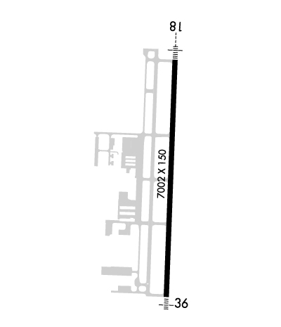
| Lat: N 3310.6 Long: W 09635.3 Elev: 589 Var: -03 Longest Runway: 7002 | ||
| Clr Del: 121.35 TW CLD Dept. ATIS: 119.92 Arr. ATIS: 119.92 AWOS: 119.92 Ground: 121.87 Tower: 118.82 | ||

| ||||||||||||||||||||||||||||||||||||||||||||
| ||||||||||||||||||||||||||||||||||||||||||||
| ||||||||||||||||||||||||||||||||||||||||||||
| Rwy | Rwy | |||||||
| 7002x150 | 7002' | 109.35 - 179° | 7002x150 | 7002' | ||||
| Runway ID | Single Wheel | Double Wheel | Double Tandem Wheel | Dual Double Wheel |
| 18/36 | 75,000 | 150,000 | 450,000 | N/A |
| These numbers are Advisory and are not limits. The Airport Manager should have more accurate Weight Limits | ||||
 Airport Diagram might not be current. | |
| Facility Name: | MCKINNEY NTL |
| City Name: | DALLAS |
| County: | COLLIN |
| State abbrev: | TX |
| State Name: | TEXAS |
| Ownership: | PUBLICLY OWNED |
| Use: | OPEN TO THE PUBLIC |
| Owner's Name: | CITY OF MC KINNEY |
| Address: | PO BOX 517 |
| MC KINNEY, TX 75070 | |
| Owner's Phone: | 972-562-4214 |
| Manager's Name: | KEN CARLEY |
| Address: | PO BOX 517 |
| MC KINNEY, TX 75070 | |
| Phone: | (972) 562-4053 |
| FAA Region: | SOUTHWEST |
| FAA Field Office: | TEX |

| Date | Sunrise | Sunset |
|---|---|---|
| 09/24/21 Friday | 7:16 | 19:21 |
| 09/25/21 Saturday | 7:16 | 19:19 |
| 09/26/21 Sunday | 7:17 | 19:18 |
| 09/27/21 Monday | 7:18 | 19:17 |
| 09/28/21 Tuesday | 7:18 | 19:15 |
| 09/29/21 Wednesday | 7:19 | 19:14 |
| 09/30/21 Thursday | 7:20 | 19:12 |
| 10/01/21 Friday | 7:20 | 19:11 |
| 10/02/21 Saturday | 7:21 | 19:10 |
| 10/03/21 Sunday | 7:22 | 19:08 |
| 10/04/21 Monday | 7:23 | 19:07 |
| 10/05/21 Tuesday | 7:23 | 19:06 |
| 10/06/21 Wednesday | 7:24 | 19:05 |
| 10/07/21 Thursday | 7:25 | 19:03 |
| Airport Attendance Schedule | 7 Days A Week 0600-2200 |
| Airport Status | OPERATIONAL (This Status can change at any time - please check NOTAMS) |
| Airport Lighting Schedule | WHEN ATCT CLSD ACTVT MALSR RWY 18; MALS RWY 36; PAPI RWY 18 & 36; HIRL RWY 18/36 - CTAF. |
| Airport Storage Available | Tie Downs, Hanger |
| Extra Services Available | Air Ambulance, Charter, Flight Instruction, Aircraft Rental |
| Wind Indicator | YES - (lighted) |
| Control Tower | YES |
| CTAF Frequency | 118.825 |
| Unicom Frequency | 122.950 |
| Rotating Beacon Color | CLEAR-GREEN (Light Land Airport) |
| Segmented Circle | YES |
| Landing Fee | NO |
| Airport Inspected | STATE - performed by STATE AERONAUTICAL PERSONNEL |
| Inspection Date | 01/15/2020 |
| Type of Fuel Available | Grade 100LL, JET A-1 (icing inhibitor, freeze point -50C) |
| Airframe Repair Service | MAJOR |
| Power Plant Repair Service | MAJOR |
| Latitude | N3310.6 |
| Longitude | W09635.3 (ESTIMATED) |
| Arpt Elevation | 588ft (SURVEYED) |
| Magnetic Variation | 03E |
| 32 miles N | of DALLAS |
| Traffic Pattern Altitude | |
| Sectional Chart | DALLAS-FT WORTH |
| Operations (Reported) | Yearly | Avg. Daily |
|---|---|---|
| General Aviation Transient | 35623 | 98 |
| General Aviation Local | 71238 | 195 |
| Air Taxi | 2042 | 6 |
| Commerical | 0 | 0 |
| Commuter | 0 | 0 |
| Military | 55 | 0 |
| Aircraft based on Field | |
|---|---|
| General Aviation Singles | 144 |
| General Aviation Multi | 25 |
| Jet Aircraft | 29 |
| General Aviation Helicopters | 4 |
| Military Aircraft | 0 |
| Gliders | 0 |
| Ultralights | 0 |
| FSS on field | NO |
| FSS tie-in | FORT WORTH |
| FSS Phone | 1-800-WX-BRIEF |
| Who issues Notams | TKI |
| Notam D service at airport | YES |
| ARTCC Name | FORT WORTH |
| Airport Certification | |
| Aircraft Rescue & Firefighting Index | None |
| Airport of Entry | No |
| Custom Landing Rights | No; US CUSTOMS USER FEE ARPT. |
| Joint Civil/Military | No |
| Military Landing rights | YES |
| NATIONAL PLAN OF INTEGRATED AIRPORT SYSTEMS (NPIAS) |
| GRANT AGREEMENTS UNDER FAAP/ADAP/AIP |
| ASSURANCES PURSUANT TO TITLE VI, CIVIL RIGHTS ACT OF 1964 |
| BIRD ACTIVITY INVOF ARPT. |
Airport Communications & Frequencies:
| ||||||||||||||||||||||
| Runway: 18 | Runway: 36 | ||
| Mag heading: | 179° | Mag heading: | 359° |
| Rwy Slope: | .19% Up | Rwy Slope: | -.19% Down |
| Approach: | ILS/DME | Approach: | |
| Pattern: | Left Traffic | Pattern: | Right Traffic |
| Markings: | PRECISION INSTRUMENT | Markings: | NONPRECISION INSTRUMENT |
| Marking Condition: | GOOD | Marking Condition: | GOOD |
| Arresting Dev: | Arresting Dev: | ||
| Lat & Long: | N3311.2 W09635.3 | Lat. & Long.: | N3310.0 W09635.4 |
| Elev: | 575.9 ft. MSL | Elev: | 588.9 ft. MSL |
| TCH: | 50 ft. AGL | TCH: | 50 ft. AGL |
| Visual Glide Path: | 3.00 degrees | Visual Glide Path: | 3.00 degrees |
| Displaced Threshold: | No | Displaced Threshold: | No |
| Touchdown Zone: | YES | Touchdown Zone: | YES |
| Touchdown Elev.: | 575.9 feet | Touchdown Elev.: | 588.9 feet |
| Visual Glide Slope: | 4-Light PAPI on LEFT side of Runway | Visual Glide Slope: | 4-Light PAPI on LEFT side of Runway |
| RVR Equipment: | RVR Equipment: | ||
| RVV Equipment: | NO | RVV Equipment: | NO |
| Approach Lights: | MALSR - 1,400 foot medium intensity approach lighting system with runway alignment indicator lights | Approach Lights: | MALS - 1,400 foot medium intensity approach lighting system |
| REIL: | NO | REIL: | NO |
| Centerline Lights: | NO | Centerline Lights: | NO |
| Touchdown lights: | NO | Touchdown lights: | NO |
| Runway Category: | Precision Instrument Runway | Runway Category: | D |
| Declared Distances: | Declared Distances: |
Thanks for using FltPlan.com
all rights reserved © 1999-2021 by Flight Plan LLC