| LUIS MUNOZ MARIN INTL SAN JUAN PR |
| |
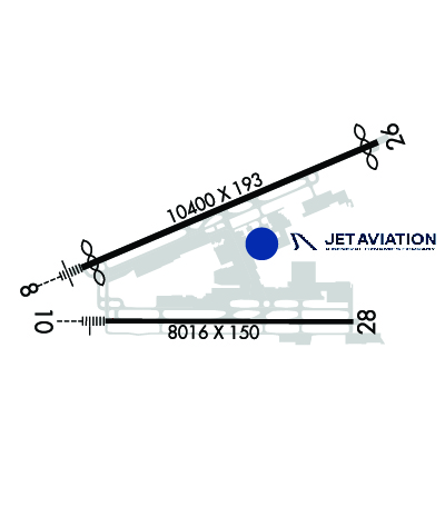
| Lat: N 1826.4 Long: W 06600.1 Elev: 10 Var: +11 Longest Runway: 10400 | ||
| Clr Del: 126.4 Dept. ATIS: 125.8 Arr. ATIS: 125.8 Ground: 121.9 Tower: 132.05 | ||
| |||||||||||||||||||||||||||||||||||||||||||||||||||||||||||||||||||||
| |||||||||||||||||||||||||||||||||||||||||||||||||||||||||||||||||||||
| |||||||||||||||||||||||||||||||||||||||||||||||||||||||||||||||||||||
| |||||||||||||||||||||||||||||||||||||||||||||||||||||||||||||||||||||
| |||||||||||||||||||||||||||||||||||||||||||||||||||||||||||||||||||||
| |||||||||||||||||||||||||||||||||||||||||||||||||||||||||||||||||||||
| |||||||||||||||||||||||||||||||||||||||||||||||||||||||||||||||||||||
| Rwy | Rwy | |||||||
| 10400x193 | 10000' | 110.30 - 077° | 10400x193 | 10000' | ||||
| 8016x150 | 8016' | 109.70 - 101° | 8016x150 | 8016' | ||||
| Runway ID | Single Wheel | Double Wheel | Double Tandem Wheel | Dual Double Wheel |
| 08/26 | 120,000 | 250,000 | 499,000 | 1,024,000 |
| 10/28 | 120,000 | 250,000 | 550,000 | 1,075,000 |
| These numbers are Advisory and are not limits. The Airport Manager should have more accurate Weight Limits | ||||
 Airport Diagram might not be current. | |
| Facility Name: | LUIS MUNOZ MARIN INTL |
| City Name: | SAN JUAN |
| County: | --PUERTO RICO |
| State abbrev: | PR |
| State Name: | PUERTO RICO |
| Ownership: | PUBLICLY OWNED |
| Use: | OPEN TO THE PUBLIC |
| Owner's Name: | PUERTO RICO PORTS AUTH |
| Address: | GPO BOX 362829 |
| SAN JUAN, PR 00936-2829 | |
| Owner's Phone: | 787-289-7240 |
| Manager's Name: | MR. JORGE HERNANDEZ |
| Address: | P. O. BOX 38085 |
| SAN JUAN, PR 00937-1085 | |
| Phone: | (787) 289-7240 |
| FAA Region: | SOUTHERN |
| FAA Field Office: | ATL |
| Date | Sunrise | Sunset |
|---|---|---|
| 05/29/25 Thursday | 5:47 | 18:56 |
| 05/30/25 Friday | 5:47 | 18:56 |
| 05/31/25 Saturday | 5:47 | 18:56 |
| 06/01/25 Sunday | 5:47 | 18:57 |
| 06/02/25 Monday | 5:47 | 18:57 |
| 06/03/25 Tuesday | 5:47 | 18:58 |
| 06/04/25 Wednesday | 5:47 | 18:58 |
| 06/05/25 Thursday | 5:47 | 18:58 |
| 06/06/25 Friday | 5:47 | 18:59 |
| 06/07/25 Saturday | 5:47 | 18:59 |
| 06/08/25 Sunday | 5:47 | 18:59 |
| 06/09/25 Monday | 5:47 | 19:00 |
| 06/10/25 Tuesday | 5:47 | 19:00 |
| 06/11/25 Wednesday | 5:47 | 19:00 |
| Airport Attendance Schedule | CONTINUOUS |
| Airport Status | OPERATIONAL (This Status can change at any time - please check NOTAMS) |
| Airport Lighting Schedule | SS-SR |
| Airport Storage Available | Hanger |
| Extra Services Available | Air Freight, Cargo Handling, Charter |
| Wind Indicator | YES - (lighted) |
| Control Tower | YES |
| CTAF Frequency | |
| Unicom Frequency | 123.000 |
| Rotating Beacon Color | WG |
| Segmented Circle | NO |
| Landing Fee | YES |
| Airport Inspected | FEDERAL - performed by FAA AIRPORTS FIELD PERSONNEL |
| Inspection Date | 06/13/2024 |
| Type of Fuel Available | Grade 100, JET AA++ |
| Airframe Repair Service | MAJOR |
| Power Plant Repair Service | MAJOR |
| Latitude | N1826.4 |
| Longitude | W06600.1 (ESTIMATED) |
| Arpt Elevation | 9ft (SURVEYED) |
| Magnetic Variation | 11W |
| 3 miles SE | of SAN JUAN |
| Traffic Pattern Altitude | |
| Sectional Chart | PUERTO RICO-VIRGIN ISLANDS |
| Operations (Reported) | Yearly | Avg. Daily |
|---|---|---|
| General Aviation Transient | 0 | 0 |
| General Aviation Local | 0 | 0 |
| Air Taxi | 0 | 0 |
| Commerical | 0 | 0 |
| Commuter | 0 | 0 |
| Military | 0 | 0 |
| Aircraft based on Field | |
|---|---|
| General Aviation Singles | 0 |
| General Aviation Multi | 0 |
| Jet Aircraft | 0 |
| General Aviation Helicopters | 0 |
| Military Aircraft | 0 |
| Gliders | 0 |
| Ultralights | 0 |
| FSS on field | NO |
| FSS tie-in | SAN JUAN |
| FSS Phone | 1-800-WX-BRIEF |
| Who issues Notams | TJSJ |
| Notam D service at airport | YES |
| ARTCC Name | SAN JUAN |
| Airport Certification | AIRPORT RECEIVING SCHEDULED AIR CARRIER SERVICE FROM CARRIERS CERTIFICATED BY THE CIVIL AERONAUTICS BOARD |
| Aircraft Rescue & Firefighting Index | AIRPORT HAS A CERTIFICATE UNDER CFR PART 139 |
| Airport of Entry | No |
| Custom Landing Rights | YES |
| Joint Civil/Military | No |
| Military Landing rights | YES |
| NATIONAL PLAN OF INTEGRATED AIRPORT SYSTEMS (NPIAS) |
| GRANT AGREEMENTS UNDER FAAP/ADAP/AIP |
| ASSURANCES PURSUANT TO TITLE VI, CIVIL RIGHTS ACT OF 1964 |
| APRON 12 AVBL FOR GA ACFT ONLY. |
| ANG MILITARY APRON - OFFL BUS. NO OVNGT PRKG ALLOWED. OPR 1130-2000Z MON-FRI, CLSD WKEND AND HOL. PPR DSN 740-9629, C787-253-7629. ALL TRAN ACFT CTC COMD POST UHF 235.0, 20 MIN PRIOR TO LDG AND PRIOR TO ENG START. |
| TWY J BTN J1 AND J5 (NOT INCLUDING J5) CLSD TO ACFT WITH GREATER THAN 118 FT WINGSPAN. |
| ENGINE RUNUPS PROHIBITED ON GATES AREA. |
| ACFT 180 TURNS ON TWYS REQUIRES OPS COORDINATIONS. |
| FBO/GROUND HANDLER MUST SUBMIT 72 HRS PPR FOR ALL MIL ACFT TO: CCO@AEROSTARAIRPORTS.COM OR BY PHONE TO: 787-253-0979 |
| ALL PVT AND CORPORATE AIRCRAFT MUST CONTACT ARPT OPS, BEFORE ARRIVAL, FOR FBOS & GROUND HANDLING INFO AT 787-253-0979. |
| MILITARY: ANG: INBD ACFT ORIGINATING FR OCONUS WITH A PPR FOR MUNIZ ANGB APN MUST CLEAR CUSTOMS AND BORDER PROTECTION AT CIV SIDE. PRIOR COORD MUST BE MADE WITH ANG AMOPS, FONE 740-9629 AT LEAST ONE BUS DAY PRIOR TO ARRIVAL. |
| RWY 08/2 6 RWY 08 FST 680 FT CONC. |
| RWY 08/2 6 PCR VALUE: 888/R/B/W/T |
| RWY 10/2 8 PCR VALUE: 1050/R/B/W/T |
Airport Communications & Frequencies:
| ||||||||||||||||||||||||||||||||||||||||||||||
| Runway: 08 | Runway: 26 | ||
| Mag heading: | 78° | Mag heading: | 258° |
| Rwy Slope: | -.01% Down | Rwy Slope: | .01% Up |
| Approach: | ILS | Approach: | |
| Pattern: | Right Traffic | Pattern: | Left Traffic |
| Markings: | PRECISION INSTRUMENT | Markings: | PRECISION INSTRUMENT |
| Marking Condition: | GOOD | Marking Condition: | GOOD |
| Arresting Dev: | Arresting Dev: | ||
| Lat & Long: | N1826.3 W06601.0 | Lat. & Long.: | N1827.0 W06559.3 |
| Elev: | 8.2 ft. MSL | Elev: | 6.9 ft. MSL |
| TCH: | 70 ft. AGL | TCH: | |
| Visual Glide Path: | 3.00 degrees | Visual Glide Path: | |
| Displaced Threshold: | 400 feet | Displaced Threshold: | 400 feet |
| Touchdown Zone: | YES | Touchdown Zone: | YES |
| Touchdown Elev.: | 9.3 feet | Touchdown Elev.: | 7.4 feet |
| Visual Glide Slope: | 4-Light PAPI on LEFT side of Runway | Visual Glide Slope: | |
| RVR Equipment: | RVR Equipment: | ||
| RVV Equipment: | NO | RVV Equipment: | NO |
| Approach Lights: | MALSR - 1,400 foot medium intensity approach lighting system with runway alignment indicator lights | Approach Lights: | |
| REIL: | NO | REIL: | YES |
| Centerline Lights: | NO | Centerline Lights: | NO |
| Touchdown lights: | NO | Touchdown lights: | NO |
| Runway Category: | Precision Instrument Runway | Runway Category: | Runway with a Non-precision Approach having visibility minimums greater than 3/4 mile |
| Declared Distances: | TORA:10400' TODA:10400' ASDA:9784' LDA:9384' | Declared Distances: | TORA:10400' TODA:10400' ASDA:10308' LDA:9908' |
| Obstructions: | TREE | Obstructions: | TREE |
| Marked: | NOT Marked/Lighted | Marked: | NOT Marked/Lighted |
| Clearance slope: | 42:1 | Clearance slope: | 33:1 |
| Obstruction height: | 59 feet AGL | Obstruction height: | 72 feet AGL |
| Dist. from runway: | 2675 feet | Dist. from runway: | 2600 feet |
| Centerline offset: | 300 right of centerline | Centerline offset: | 800 feet right of centerline |
| Comments: | Comments: |
| Runway: 10 | Runway: 28 | ||
| Mag heading: | 101° | Mag heading: | 281° |
| Rwy Slope: | .00% Up | Rwy Slope: | .00% Down |
| Approach: | ILS/DME | Approach: | |
| Pattern: | Right Traffic | Pattern: | Left Traffic |
| Markings: | PRECISION INSTRUMENT | Markings: | PRECISION INSTRUMENT |
| Marking Condition: | GOOD | Marking Condition: | GOOD |
| Arresting Dev: | Arresting Dev: | ||
| Lat & Long: | N1826.0 W06600.8 | Lat. & Long.: | N1826.0 W06559.4 |
| Elev: | 9.3 ft. MSL | Elev: | 9.5 ft. MSL |
| TCH: | 53 ft. AGL | TCH: | 53 ft. AGL |
| Visual Glide Path: | 3.00 degrees | Visual Glide Path: | 3.00 degrees |
| Displaced Threshold: | No | Displaced Threshold: | No |
| Touchdown Zone: | YES | Touchdown Zone: | YES |
| Touchdown Elev.: | 9.3 feet | Touchdown Elev.: | 9.6 feet |
| Visual Glide Slope: | 4-Light PAPI on LEFT side of Runway | Visual Glide Slope: | 4-Light PAPI on LEFT side of Runway |
| RVR Equipment: | RVR Equipment: | ||
| RVV Equipment: | NO | RVV Equipment: | NO |
| Approach Lights: | MALSR - 1,400 foot medium intensity approach lighting system with runway alignment indicator lights | Approach Lights: | |
| REIL: | NO | REIL: | NO |
| Centerline Lights: | NO | Centerline Lights: | NO |
| Touchdown lights: | NO | Touchdown lights: | NO |
| Runway Category: | Precision Instrument Runway | Runway Category: | Runway with a Visual Approach |
| Declared Distances: | TORA:8016' TODA:8016' ASDA:8016' LDA:8016' | Declared Distances: | TORA:8016' TODA:8016' ASDA:8016' LDA:8016' |
| Obstructions: | TREE | Obstructions: | TREES |
| Marked: | NOT Marked/Lighted | Marked: | NOT Marked/Lighted |
| Clearance slope: | 40:1 | Clearance slope: | 33:1 |
| Obstruction height: | 50 feet AGL | Obstruction height: | 24 feet AGL |
| Dist. from runway: | 2200 feet | Dist. from runway: | 1000 feet |
| Centerline offset: | 300 left of centerline | Centerline offset: | B |
| Comments: | Comments: |
Thanks for using FltPlan.com
all rights reserved © 1999-2025 by Flight Plan LLC