
| EUGENIO HOSTOS, PUERTO RICO MAYAGUEZ PR |
| |
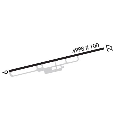
| Lat: N 1815.3 Long: W 06708.9 Elev: 29 Var: +10 Longest Runway: 4998 | ||
| CTAF: 122.8 | ||
| ||||||||||||||||||||||||||||||||
| ||||||||||||||||||||||||||||||||
| Rwy | Rwy | |||||||
| 4998x75 | 4699' | 4998x75 | 4998' | |||||
| Runway ID | Single Wheel | Double Wheel | Double Tandem Wheel | Dual Double Wheel |
| 09/27 | 85,000 | 108,000 | 170,000 | N/A |
| These numbers are Advisory and are not limits. The Airport Manager should have more accurate Weight Limits | ||||
 Airport Diagram might not be current. | |
| Facility Name: | EUGENIO MARIA DE HOSTOS |
| City Name: | MAYAGUEZ |
| County: | --PUERTO RICO |
| State abbrev: | PR |
| State Name: | PUERTO RICO |
| Ownership: | PUBLICLY OWNED |
| Use: | OPEN TO THE PUBLIC |
| Owner's Name: | PUERTO RICO PORTS AUTH |
| Address: | P.O. BOX 362829 |
| SAN JUAN, PR 00932-2829 | |
| Owner's Phone: | 787-729-8715 |
| Manager's Name: | WILLIAM FEBLES |
| Address: | BOX 710 |
| MAYAGUEZ, PR 00681-0710 | |
| Phone: | 787-833-0148 |
| FAA Region: | SOUTHERN |
| FAA Field Office: | ATL |
| Date | Sunrise | Sunset |
|---|---|---|
| 06/08/26 Monday | 5:52 | 19:04 |
| 06/09/26 Tuesday | 5:52 | 19:04 |
| 06/10/26 Wednesday | 5:52 | 19:04 |
| 06/11/26 Thursday | 5:52 | 19:04 |
| 06/12/26 Friday | 5:52 | 19:05 |
| 06/13/26 Saturday | 5:52 | 19:05 |
| 06/14/26 Sunday | 5:52 | 19:05 |
| 06/15/26 Monday | 5:52 | 19:06 |
| 06/16/26 Tuesday | 5:53 | 19:06 |
| 06/17/26 Wednesday | 5:53 | 19:06 |
| 06/18/26 Thursday | 5:53 | 19:06 |
| 06/19/26 Friday | 5:53 | 19:07 |
| 06/20/26 Saturday | 5:53 | 19:07 |
| 06/21/26 Sunday | 5:53 | 19:07 |
| Airport Attendance Schedule | MON-FRI 0730-1600 |
| Airport Status | OPERATIONAL (This Status can change at any time - please check NOTAMS) |
| Airport Lighting Schedule | RWY 09/27 MIRLS SS-SR. ACTVT PAPI RWYS 09 & 27; REILS RWY 09 - CTAF. |
| Airport Storage Available | NONE |
| Extra Services Available | NONE |
| Wind Indicator | YES - (lighted) |
| Control Tower | NO |
| CTAF Frequency | 122.800 |
| Unicom Frequency | 122.800 |
| Rotating Beacon Color | WG |
| Segmented Circle | YES |
| Landing Fee | YES; FEE FOR ALL ACFT. |
| Airport Inspected | FEDERAL - performed by PRIVATE CONTRACT PERSONNEL |
| Inspection Date | 05/03/2022 |
| Type of Fuel Available | None |
| Airframe Repair Service | NONE |
| Power Plant Repair Service | NONE |
| Latitude | N1815.3 |
| Longitude | W06708.9 (ESTIMATED) |
| Arpt Elevation | 28ft (SURVEYED) |
| Magnetic Variation | 10W |
| 3 miles N | of MAYAGUEZ |
| Traffic Pattern Altitude | 800 |
| Sectional Chart | PUERTO RICO-VIRGIN ISLANDS |
| Operations (Reported) | Yearly | Avg. Daily |
|---|---|---|
| General Aviation Transient | 0 | 0 |
| General Aviation Local | 0 | 0 |
| Air Taxi | 0 | 0 |
| Commerical | 0 | 0 |
| Commuter | 0 | 0 |
| Military | 0 | 0 |
| Aircraft based on Field | |
|---|---|
| General Aviation Singles | 0 |
| General Aviation Multi | 0 |
| Jet Aircraft | 0 |
| General Aviation Helicopters | 0 |
| Military Aircraft | 0 |
| Gliders | 0 |
| Ultralights | 0 |
| FSS on field | NO |
| FSS tie-in | SAN JUAN |
| FSS Phone | 1-800-WX-BRIEF |
| Who issues Notams | TJMZ |
| Notam D service at airport | YES |
| ARTCC Name | SAN JUAN |
| Airport Certification | |
| Aircraft Rescue & Firefighting Index | None |
| Airport of Entry | No |
| Custom Landing Rights | No |
| Joint Civil/Military | No |
| Military Landing rights | YES |
| NATIONAL PLAN OF INTEGRATED AIRPORT SYSTEMS (NPIAS) |
| GRANT AGREEMENTS UNDER FAAP/ADAP/AIP |
| SURPLUS PROPERTY AGREEMENT UNDER PUBLIC LAW 289 |
| ASSURANCES PURSUANT TO TITLE VI, CIVIL RIGHTS ACT OF 1964 |
| BIRDS ON AND INVOF ARPT. |
| FOR CD IF FREQ ARE OTS CTC SAN JUAN CERAP AT 787-253-8664/8667 |
| ULTRALIGHT ACTIVITY. |
Airport Communications & Frequencies:
| |||||||||
| Runway: 09 | Runway: 27 | ||
| Mag heading: | 86° | Mag heading: | 266° |
| Rwy Slope: | .16% Up | Rwy Slope: | -.16% Down |
| Approach: | Approach: | ||
| Pattern: | Left Traffic | Pattern: | Left Traffic |
| Markings: | NONPRECISION INSTRUMENT | Markings: | NONPRECISION INSTRUMENT |
| Marking Condition: | GOOD | Marking Condition: | GOOD |
| Arresting Dev: | Arresting Dev: | ||
| Lat & Long: | N1815.2 W06709.3 | Lat. & Long.: | N1815.4 W06708.5 |
| Elev: | 16.3 ft. MSL | Elev: | 24.5 ft. MSL |
| TCH: | 40 ft. AGL | TCH: | 51 ft. AGL |
| Visual Glide Path: | 3.00 degrees | Visual Glide Path: | 3.50 degrees |
| Displaced Threshold: | 299 feet | Displaced Threshold: | No |
| Touchdown Zone: | YES | Touchdown Zone: | YES |
| Touchdown Elev.: | 28.7 feet | Touchdown Elev.: | 28.7 feet |
| Visual Glide Slope: | 4-Light PAPI on LEFT side of Runway | Visual Glide Slope: | 4-Light PAPI on LEFT side of Runway |
| RVR Equipment: | RVR Equipment: | ||
| RVV Equipment: | NO | RVV Equipment: | NO |
| Approach Lights: | Approach Lights: | ||
| REIL: | YES; NSTD. | REIL: | NO |
| Centerline Lights: | NO | Centerline Lights: | NO |
| Touchdown lights: | NO | Touchdown lights: | NO |
| Runway Category: | Runway with a Non-precision Approach having visibility minimums greater than 3/4 mile | Runway Category: | Runway with a Visual Approach |
| Declared Distances: | TORA:4998' TODA:4998' ASDA:4998' LDA:4699' | Declared Distances: | TORA:4998' TODA:4998' ASDA:4699' LDA:4699' |
| Obstructions: | TREE; 47 FT LIGHTED/MARKED POWER LINES, 1800 FT DSTC, 0 FT B, 34:1. | Obstructions: | TREES |
| Marked: | NOT Marked/Lighted | Marked: | NOT Marked/Lighted |
| Clearance slope: | 8:1; 30 FT TREE, 200 FT DSTC AT BEGINNING OF THE APCH SFC, 190 FT L, OBSTN CLNC 0:1. | Clearance slope: | 1:1 |
| Obstruction height: | 16 feet AGL | Obstruction height: | 30 feet AGL |
| Dist. from runway: | 338 feet | Dist. from runway: | 200 feet |
| Centerline offset: | 127 left of centerline | Centerline offset: | 190 feet left of centerline |
| Comments: | Comments: | 20' TREES, 57 FT DSTC, 140 FT L. |
Thanks for using FltPlan.com
all rights reserved © 1999-2026 by Flight Plan LLC