
| DOMINICCI, PUERTO RICO SAN JUAN PR |
| |
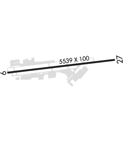
| Lat: N 1827.4 Long: W 06605.9 Elev: 10 Var: +12 Longest Runway: 5539 | ||
| Dept. ATIS: 120.4 Arr. ATIS: 120.4 Ground: 121.7 Tower: 135.87 | ||
| ||||||||||||||||||||||||||||||||
| ||||||||||||||||||||||||||||||||
| Rwy | Rwy | |||||||
| 5539x100 | 5241' | 5539x100 | 4599' | |||||
| Runway ID | Single Wheel | Double Wheel | Double Tandem Wheel | Dual Double Wheel |
| 09/27 | 52,000 | 88,000 | 160,000 | N/A |
| These numbers are Advisory and are not limits. The Airport Manager should have more accurate Weight Limits | ||||
 Airport Diagram might not be current. | |
| Facility Name: | FERNANDO LUIS RIBAS DOMINICCI |
| City Name: | SAN JUAN |
| County: | --PUERTO RICO |
| State abbrev: | PR |
| State Name: | PUERTO RICO |
| Ownership: | PUBLICLY OWNED |
| Use: | OPEN TO THE PUBLIC |
| Owner's Name: | PUERTO RICO PORTS AUTHORITY |
| Address: | GPO BOX 362829 |
| SAN JUAN, PR 00936-2829 | |
| Owner's Phone: | (787) 729-8715 |
| Manager's Name: | |
| Address: | GPO BOX 362829 |
| SAN JUAN, PR 00936 | |
| Phone: | 787-729-8715; AMGR EXT 3331, OPS EXT 3332. |
| FAA Region: | SOUTHERN |
| FAA Field Office: | ATL |
| Date | Sunrise | Sunset |
|---|---|---|
| 09/24/21 Friday | 6:14 | 18:19 |
| 09/25/21 Saturday | 6:14 | 18:18 |
| 09/26/21 Sunday | 6:14 | 18:17 |
| 09/27/21 Monday | 6:14 | 18:16 |
| 09/28/21 Tuesday | 6:14 | 18:16 |
| 09/29/21 Wednesday | 6:14 | 18:15 |
| 09/30/21 Thursday | 6:15 | 18:14 |
| 10/01/21 Friday | 6:15 | 18:13 |
| 10/02/21 Saturday | 6:15 | 18:12 |
| 10/03/21 Sunday | 6:15 | 18:11 |
| 10/04/21 Monday | 6:15 | 18:11 |
| 10/05/21 Tuesday | 6:16 | 18:10 |
| 10/06/21 Wednesday | 6:16 | 18:09 |
| 10/07/21 Thursday | 6:16 | 18:08 |
| Airport Attendance Schedule | 7 Days A Week 0600-1930 |
| Airport Status | OPERATIONAL (This Status can change at any time - please check NOTAMS) |
| Airport Lighting Schedule | AFTR TWR HRS, MIRLS PRESET TO MED. |
| Airport Storage Available | Tie Downs |
| Extra Services Available | Air Freight, Avionics, Charter, Flight Instruction, Aircraft Rental |
| Wind Indicator | YES - (lighted) |
| Control Tower | YES |
| CTAF Frequency | 135.875 |
| Unicom Frequency | |
| Rotating Beacon Color | CLEAR-GREEN (Light Land Airport) |
| Segmented Circle | NO |
| Landing Fee | YES |
| Airport Inspected | STATE - performed by PRIVATE CONTRACT PERSONNEL |
| Inspection Date | 04/17/2017 |
| Type of Fuel Available | Grade 100, JET A (freeze point -40C) |
| Airframe Repair Service | MAJOR |
| Power Plant Repair Service | MAJOR |
| Latitude | N1827.4 |
| Longitude | W06605.9 (ESTIMATED) |
| Arpt Elevation | 9ft (SURVEYED) |
| Magnetic Variation | 12W |
| 0 miles W | of SAN JUAN |
| Traffic Pattern Altitude | 990 |
| Sectional Chart | PUERTO RICO-VIRGIN ISLANDS |
| Operations (Reported) | Yearly | Avg. Daily |
|---|---|---|
| General Aviation Transient | 43375 | 119 |
| General Aviation Local | 37076 | 102 |
| Air Taxi | 12837 | 35 |
| Commerical | 0 | 0 |
| Commuter | 0 | 0 |
| Military | 2509 | 7 |
| Aircraft based on Field | |
|---|---|
| General Aviation Singles | 93 |
| General Aviation Multi | 50 |
| Jet Aircraft | 16 |
| General Aviation Helicopters | 33 |
| Military Aircraft | 18 |
| Gliders | 0 |
| Ultralights | 0 |
| FSS on field | NO |
| FSS tie-in | SAN JUAN |
| FSS Phone | 1-800-WX-BRIEF |
| Who issues Notams | TJSJ |
| Notam D service at airport | YES |
| ARTCC Name | SAN JUAN |
| Airport Certification | |
| Aircraft Rescue & Firefighting Index | INDEX A-1 ARFF EQUIPMENT AVAIL 0600-1930. |
| Airport of Entry | No |
| Custom Landing Rights | YES |
| Joint Civil/Military | No |
| Military Landing rights | YES |
| NATIONAL PLAN OF INTEGRATED AIRPORT SYSTEMS (NPIAS) |
| WHEN ATCT CLSD STRAIGHT IN PATTERN NOT AUTHORIZED. |
| CUSTOMS/IMMIGRATION OPR HRS 1400-2400Z. |
| RY 09/27 CLASSIFIED AS B-II. ACFT EXCEEDING ARPT REFERENCE CODE USE CAUTION. |
| INDEX A-1 ARFF EQUIPMENT AVAIL 0600-1930. |
| NORTH TWY UNLGTD. |
| RWY 09: THLD 300' |
| SAN JUAN BAY CRUISE SHIP MANEUVERING AREA. CAUTION FOR TALL VESSEL OBSTRUCTION ON FINAL APPROACH TO RWY 9 OR DEPARTING RWY 27. |
| CAUTION DEPARTING RWY 9; OBSTRUCTION, TALL VESSEL AT THE MARINA. |
| 3 LGTD CRANES 346 FT HIGH 0.5 MI SE AER 09. EXERCISE CTN USING RIGHT TFC PAT FOR RWY 09. |
| WHEN TWR CLSD CTC SAN JUAN CERAP AT 787-253-8664/8664 |
| TWY A4, A5, & A6 CLSD TO ACFT WITH WINGSPAN MORE THAN 49 FT. |
| FOR ACFT RESCUE CALL 787-729-8859. |
| FEE FOR ALL ACFT. |
| BIRDS ON & INVOF ARPT. |
Airport Communications & Frequencies:
| |||||||||||||||||||||||||||||||
| Runway: 09 | Runway: 27 | ||
| Mag heading: | 95° | Mag heading: | 275° |
| Rwy Slope: | -.03% Down | Rwy Slope: | .03% Up |
| Approach: | Approach: | ||
| Pattern: | Left Traffic; EXERCISE CAUTION USING RIGHT TRAFFIC PATTERN FOR RWY 09. | Pattern: | Right Traffic |
| Markings: | NONPRECISION INSTRUMENT | Markings: | NONPRECISION INSTRUMENT |
| Marking Condition: | GOOD | Marking Condition: | GOOD |
| Arresting Dev: | Arresting Dev: | ||
| Lat & Long: | N1827.4 W06606.4 | Lat. & Long.: | N1827.5 W06605.4 |
| Elev: | 8.3 ft. MSL | Elev: | 6.5 ft. MSL |
| TCH: | 44 ft. AGL | TCH: | |
| Visual Glide Path: | 2.83 degrees | Visual Glide Path: | |
| Displaced Threshold: | 298 feet | Displaced Threshold: | 940 feet |
| Touchdown Zone: | YES | Touchdown Zone: | YES |
| Touchdown Elev.: | 9.8 feet | Touchdown Elev.: | 9.0 feet |
| Visual Glide Slope: | 2-Light PAPI on RIGHT side of Runway | Visual Glide Slope: | |
| RVR Equipment: | RVR Equipment: | ||
| RVV Equipment: | NO | RVV Equipment: | NO |
| Approach Lights: | Approach Lights: | ||
| REIL: | NO | REIL: | NO |
| Centerline Lights: | NO | Centerline Lights: | NO |
| Touchdown lights: | NO | Touchdown lights: | NO |
| Runway Category: | Runway with a Non-precision Approach having visibility minimums greater than 3/4 mile | Runway Category: | Runway with a Visual Approach |
| Declared Distances: | TORA:5539' TODA:5539' ASDA:5424' LDA:5126' | Declared Distances: | TORA:5539' TODA:5539' ASDA:5239' LDA:4299' |
| Obstructions: | ALSO OCNL 90 FT BOATS, 0-200 FT DSTC, 220 FT R. | Obstructions: | ROAD |
| Marked: | NOT Marked/Lighted | Marked: | NOT Marked/Lighted |
| Clearance slope: | 50:1; OBSTN CLNC SLOPE 0:1 AT DSPLCD THLD, 15 FT RD, 0 FT DSTC, 160 FT R. | Clearance slope: | |
| Obstruction height: | Obstruction height: | 15 feet AGL | |
| Dist. from runway: | Dist. from runway: | 201 feet | |
| Centerline offset: | Centerline offset: | 90 feet right of centerline | |
| Comments: | Comments: | 8 FT. FENCE & 15 FT RD, 0-200 FT DSTC, 90 FT R. |
Thanks for using FltPlan.com
all rights reserved © 1999-2021 by Flight Plan LLC