
| RAFAEL HERNANDEZ, PUERTO RICO AGUADILLA PR |
| |
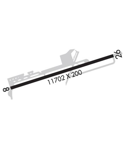
| Lat: N 1829.7 Long: W 06707.8 Elev: 238 Var: +10 Longest Runway: 11702 | ||
| Clr Del: 120.87 Dept. ATIS: 118.32 Arr. ATIS: 118.32 AWOS: 118.32 Ground: 120.87 Tower: 124.95 | ||
| |||||||||||||||||||||||||||||||||||||||
| |||||||||||||||||||||||||||||||||||||||
| |||||||||||||||||||||||||||||||||||||||
| |||||||||||||||||||||||||||||||||||||||
| |||||||||||||||||||||||||||||||||||||||
| Rwy | Rwy | |||||||
| 11702x200 | 11313' | 11702x200 | 11702' | |||||
| Runway ID | Single Wheel | Double Wheel | Double Tandem Wheel | Dual Double Wheel |
| 08/26 | 155,000 | 235,000 | 455,000 | N/A |
| These numbers are Advisory and are not limits. The Airport Manager should have more accurate Weight Limits | ||||
 Airport Diagram might not be current. | |
| Facility Name: | RAFAEL HERNANDEZ |
| City Name: | AGUADILLA |
| County: | --PUERTO RICO |
| State abbrev: | PR |
| State Name: | PUERTO RICO |
| Ownership: | PUBLICLY OWNED |
| Use: | OPEN TO THE PUBLIC |
| Owner's Name: | PUERTO RICO PORTS AUTH |
| Address: | PO BOX 250466 |
| AGUADILLA, PR 00604-0466 | |
| Owner's Phone: | 787-890-2420 |
| Manager's Name: | JOSE N. SOTO FLORES |
| Address: | BOX 250466 |
| AGUADILLA, PR 00604-0466 | |
| Phone: | 787-729-8715; 787-729-8715 X 5012 |
| FAA Region: | SOUTHERN |
| FAA Field Office: | ATL |
| Date | Sunrise | Sunset |
|---|---|---|
| 06/12/26 Friday | 5:52 | 19:05 |
| 06/13/26 Saturday | 5:52 | 19:05 |
| 06/14/26 Sunday | 5:52 | 19:06 |
| 06/15/26 Monday | 5:52 | 19:06 |
| 06/16/26 Tuesday | 5:52 | 19:06 |
| 06/17/26 Wednesday | 5:52 | 19:07 |
| 06/18/26 Thursday | 5:52 | 19:07 |
| 06/19/26 Friday | 5:53 | 19:07 |
| 06/20/26 Saturday | 5:53 | 19:07 |
| 06/21/26 Sunday | 5:53 | 19:08 |
| 06/22/26 Monday | 5:53 | 19:08 |
| 06/23/26 Tuesday | 5:53 | 19:08 |
| 06/24/26 Wednesday | 5:54 | 19:08 |
| 06/25/26 Thursday | 5:54 | 19:08 |
| Airport Attendance Schedule | CONTINUOUS |
| Airport Status | OPERATIONAL (This Status can change at any time - please check NOTAMS) |
| Airport Lighting Schedule | SS-SR |
| Airport Storage Available | Tie Downs, Hanger |
| Extra Services Available | Cargo Handling, Charter, Flight Instruction |
| Wind Indicator | YES - (lighted) |
| Control Tower | YES |
| CTAF Frequency | 124.950 |
| Unicom Frequency | |
| Rotating Beacon Color | WG |
| Segmented Circle | YES |
| Landing Fee | YES |
| Airport Inspected | FEDERAL - performed by FAA AIRPORTS FIELD PERSONNEL |
| Inspection Date | 05/23/2024 |
| Type of Fuel Available | Grade 100, JET A-1 (freeze point -50C) |
| Airframe Repair Service | MAJOR |
| Power Plant Repair Service | NONE |
| Latitude | N1829.7 |
| Longitude | W06707.8 (ESTIMATED) |
| Arpt Elevation | 237ft (SURVEYED) |
| Magnetic Variation | 10W |
| 3 miles NE | of AGUADILLA |
| Traffic Pattern Altitude | |
| Sectional Chart | PUERTO RICO-VIRGIN ISLANDS |
| Operations (Reported) | Yearly | Avg. Daily |
|---|---|---|
| General Aviation Transient | 0 | 0 |
| General Aviation Local | 0 | 0 |
| Air Taxi | 0 | 0 |
| Commerical | 0 | 0 |
| Commuter | 0 | 0 |
| Military | 0 | 0 |
| Aircraft based on Field | |
|---|---|
| General Aviation Singles | 0 |
| General Aviation Multi | 0 |
| Jet Aircraft | 0 |
| General Aviation Helicopters | 0 |
| Military Aircraft | 0 |
| Gliders | 0 |
| Ultralights | 0 |
| FSS on field | NO |
| FSS tie-in | SAN JUAN |
| FSS Phone | 1-800-WX-BRIEF |
| Who issues Notams | TJBQ |
| Notam D service at airport | YES |
| ARTCC Name | SAN JUAN |
| Airport Certification | AIRPORT RECEIVING SCHEDULED AIR CARRIER SERVICE FROM CARRIERS CERTIFICATED BY THE CIVIL AERONAUTICS BOARD |
| Aircraft Rescue & Firefighting Index | AIRPORT HAS A CERTIFICATE UNDER CFR PART 139 |
| Airport of Entry | No |
| Custom Landing Rights | YES |
| Joint Civil/Military | No |
| Military Landing rights | No |
| NATIONAL PLAN OF INTEGRATED AIRPORT SYSTEMS (NPIAS) |
| GRANT AGREEMENTS UNDER FAAP/ADAP/AIP |
| SURPLUS PROPERTY AGREEMENT UNDER PUBLIC LAW 289 |
| ASSURANCES PURSUANT TO TITLE VI, CIVIL RIGHTS ACT OF 1964 |
| FOR CUSTOMS SVC CALL 787-882-3556. FOR USDA SVC CALL 787-882-3515. |
| MAINTENANCE ENGINE RUN PROHIBITED BTN 2100 TO 0600 LCL TIME DLY, EXC FROM SAT TO SUN FROM 2100 TO 800 LCL TIME. |
| TOUCH AND GO LANDINGS PROHIBITED FROM 2200 TO 0600 LCL TIME DLY. |
| FOR CD IF FREQ ARE OTS CTC SAN JUAN CERAP AT 787-253-8664/8665 |
| NE APN IS A PUB RAMP, FOR ACFT PRKG PLS CALL BQN GND FREQ (120.875) OR CALL ARPT OPS AT (787) 729-8715 EXT. 5023 |
| TWY A BTN TWY B AND TWY C CLSD TO ACFT WINGSPAN MORE THAN 118 FT. EXC AIRLINES WITH APVD AGRMT WITH AP AUTH. |
| TWY A BTN B AND A INTS PRODUCING LOOSE AGGREGATE. TWY B PRODUCING LOOSE AGGREGATE. |
| RWY 08 & 26 THR LGTS NOT STD. |
| CONDS UNMON BTN 0330Z-1100Z. |
| INCR TO ARFF INDEX C AVBL WITH 72 HRS PREV REQ. |
| FRANGIBLE FENCE 251 FT S OF RWY 08/26 CNTRLN. |
| MILITARY AIRCRAFT WITH CLASS 1 HAZARDOUS CARGO UNABLE TO DOWNLOAD 0100Z-0500Z AND 1130Z-1600Z DAILY |
| MILITARY AIRCRAFT WITH CLASS 1 HAZARDOUS CARGO OPERATING BETWEEN 0100Z-0500Z AND 1130Z-1600Z DAILY NEED TO REQUEST PPR AT 13ATF.TJBQ.PPR@US.AF.MIL |
| TWY F CLSD TO ALL TRAFFIC INDEFLY. |
| NO 180 DEG TURNS ON RWY ASPHALT SFC FOR LARGE AND HEAVY ACFT. |
| TWY A UNLIGHTED BTN TWY C AND TWY D. |
| TWY C SOUTH OF RWY 08/26 CLSD PERMLY. |
| FOR IMMIGRATION SVC CALL 787-882-3576. |
| RWY 08/2 6 RWY CNTR SXN 80' WIDE IN GOOD COND, OUTER EDGES FAILED. |
| RWY 08/2 6 1RWY PARTIALLY ASPH AND CONC. |
| RWY 08/2 6 PCR VALUE: 310/R/A/W/T |
Airport Communications & Frequencies:
| |||||||||||||||||
| Runway: 08 | Runway: 26 | ||
| Mag heading: | 82° | Mag heading: | 262° |
| Rwy Slope: | -.37% Down | Rwy Slope: | .37% Up |
| Approach: | Approach: | ||
| Pattern: | Left Traffic | Pattern: | Left Traffic |
| Markings: | NONPRECISION INSTRUMENT | Markings: | NONPRECISION INSTRUMENT |
| Marking Condition: | GOOD | Marking Condition: | GOOD |
| Arresting Dev: | Arresting Dev: | ||
| Lat & Long: | N1829.4 W06708.7 | Lat. & Long.: | N1830.0 W06706.8 |
| Elev: | 237.6 ft. MSL | Elev: | 194.2 ft. MSL |
| TCH: | 75 ft. AGL | TCH: | 75 ft. AGL |
| Visual Glide Path: | 3.00 degrees | Visual Glide Path: | 3.00 degrees |
| Displaced Threshold: | 389 feet | Displaced Threshold: | No |
| Touchdown Zone: | YES | Touchdown Zone: | YES |
| Touchdown Elev.: | 235.5 feet | Touchdown Elev.: | 210.5 feet |
| Visual Glide Slope: | 4-Light PAPI on LEFT side of Runway | Visual Glide Slope: | 4-Light PAPI on LEFT side of Runway |
| RVR Equipment: | RVR Equipment: | ||
| RVV Equipment: | NO | RVV Equipment: | NO |
| Approach Lights: | Approach Lights: | ||
| REIL: | YES | REIL: | NO |
| Centerline Lights: | NO | Centerline Lights: | NO |
| Touchdown lights: | NO | Touchdown lights: | NO |
| Runway Category: | Runway with a Non-precision Approach having visibility minimums greater than 3/4 mile | Runway Category: | Runway with a Non-precision Approach having visibility minimums greater than 3/4 mile |
| Declared Distances: | TORA:11702' TODA:11702' ASDA:11702' LDA:11313' | Declared Distances: | TORA:11702' TODA:11702' ASDA:11313' LDA:11313' |
| Obstructions: | TREES | Obstructions: | TREES |
| Marked: | NOT Marked/Lighted | Marked: | NOT Marked/Lighted |
| Clearance slope: | 34:1 | Clearance slope: | 34:1 |
| Obstruction height: | 47 feet AGL | Obstruction height: | 52 feet AGL |
| Dist. from runway: | 1800 feet | Dist. from runway: | 2000 feet |
| Centerline offset: | 400 left of centerline | Centerline offset: | 100 feet left of centerline |
| Comments: | Comments: |
Thanks for using FltPlan.com
all rights reserved © 1999-2026 by Flight Plan LLC