
| ROHLSEN VIRGIN ISLANDS (STX) CHRISTIANSTED VI |
| |
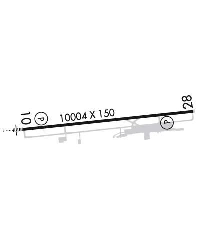
| Lat: N 1742.1 Long: W 06448.1 Elev: 73 Var: +13 Longest Runway: 10002 | ||
| Dept. ATIS: 135.65 Arr. ATIS: 135.65 Ground: 121.7 Tower: 118.6 | ||
| ||||||||||||||||||||||||||||||||||||||||||||
| ||||||||||||||||||||||||||||||||||||||||||||
| ||||||||||||||||||||||||||||||||||||||||||||
| ||||||||||||||||||||||||||||||||||||||||||||
| Rwy | Rwy | |||||||
| 10002x150 | 10002' | 109.50 - 096° | 10002x150 | 9002' | ||||
| Runway ID | Single Wheel | Double Wheel | Double Tandem Wheel | Dual Double Wheel |
| 10/28 | 100,000 | 175,000 | 300,000 | N/A |
| These numbers are Advisory and are not limits. The Airport Manager should have more accurate Weight Limits | ||||
 Airport Diagram might not be current. | |
| Facility Name: | HENRY E ROHLSEN |
| City Name: | CHRISTIANSTED |
| County: | -VIRGIN ISLANDS- |
| State abbrev: | VI |
| State Name: | VIRGIN ISLANDS |
| Ownership: | PUBLICLY OWNED |
| Use: | OPEN TO THE PUBLIC |
| Owner's Name: | VI PORT AUTHORITY |
| Address: | 8074 LINDBERGH BAY, P.O. BOX 301707 |
| ST THOMAS, VI 00803 | |
| Owner's Phone: | (340) 774-1629 |
| Manager's Name: | JEROME SHERIDAN |
| Address: | P.O. BOX 1134, CHRISTIANSTED |
| ST CROIX, VI 00821 | |
| Phone: | 340-714-6662 |
| FAA Region: | SOUTHERN |
| FAA Field Office: | ATL |

| Date | Sunrise | Sunset |
|---|---|---|
| 06/08/26 Monday | 5:43 | 18:53 |
| 06/09/26 Tuesday | 5:43 | 18:53 |
| 06/10/26 Wednesday | 5:44 | 18:54 |
| 06/11/26 Thursday | 5:44 | 18:54 |
| 06/12/26 Friday | 5:44 | 18:54 |
| 06/13/26 Saturday | 5:44 | 18:55 |
| 06/14/26 Sunday | 5:44 | 18:55 |
| 06/15/26 Monday | 5:44 | 18:55 |
| 06/16/26 Tuesday | 5:44 | 18:55 |
| 06/17/26 Wednesday | 5:44 | 18:56 |
| 06/18/26 Thursday | 5:45 | 18:56 |
| 06/19/26 Friday | 5:45 | 18:56 |
| 06/20/26 Saturday | 5:45 | 18:56 |
| 06/21/26 Sunday | 5:45 | 18:57 |
| Airport Attendance Schedule | 7 Days A Week 0500-2300 |
| Airport Status | OPERATIONAL (This Status can change at any time - please check NOTAMS) |
| Airport Lighting Schedule | ACTVT MALSR RWY 10: HIRL RWY 10/28 2300-0700 - CTAF. |
| Airport Storage Available | Hanger |
| Extra Services Available | Avionics |
| Wind Indicator | YES - (lighted) |
| Control Tower | YES |
| CTAF Frequency | 118.600 |
| Unicom Frequency | 123.000 |
| Rotating Beacon Color | WG |
| Segmented Circle | YES |
| Landing Fee | YES |
| Airport Inspected | FEDERAL - performed by FAA AIRPORTS FIELD PERSONNEL |
| Inspection Date | 06/04/2025 |
| Type of Fuel Available | Grade 100LL, JET A-1 (icing inhibitor, freeze point -50C); -10FUEL AVBL 0700-1900, OTHER TIMES 1 HR PPR CALL 340-778-9177. |
| Airframe Repair Service | NONE |
| Power Plant Repair Service | NONE |
| Latitude | N1742.1 |
| Longitude | W06448.1 (ESTIMATED) |
| Arpt Elevation | 73ft (SURVEYED) |
| Magnetic Variation | 13W |
| 6 miles SW | of CHRISTIANSTED |
| Traffic Pattern Altitude | |
| Sectional Chart | PUERTO RICO-VIRGIN ISLANDS |
| Operations (Reported) | Yearly | Avg. Daily |
|---|---|---|
| General Aviation Transient | 0 | 0 |
| General Aviation Local | 0 | 0 |
| Air Taxi | 0 | 0 |
| Commerical | 0 | 0 |
| Commuter | 0 | 0 |
| Military | 0 | 0 |
| Aircraft based on Field | |
|---|---|
| General Aviation Singles | 0 |
| General Aviation Multi | 0 |
| Jet Aircraft | 0 |
| General Aviation Helicopters | 0 |
| Military Aircraft | 0 |
| Gliders | 0 |
| Ultralights | 0 |
| FSS on field | NO |
| FSS tie-in | SAN JUAN |
| FSS Phone | 1-800-WX-BRIEF |
| Who issues Notams | TISX |
| Notam D service at airport | YES |
| ARTCC Name | SAN JUAN |
| Airport Certification | AIRPORT RECEIVING SCHEDULED AIR CARRIER SERVICE FROM CARRIERS CERTIFICATED BY THE CIVIL AERONAUTICS BOARD; CLSD TO UNSKED ACR OPNS WITH MORE THAN 30 PSGR SEATS EXCP 24 HRS PPR CTC AMGR 340-778-1012. ARFF SVC UNAVBL 2300-0500. |
| Aircraft Rescue & Firefighting Index | AIRPORT HAS A CERTIFICATE UNDER CFR PART 139 |
| Airport of Entry | No |
| Custom Landing Rights | YES |
| Joint Civil/Military | No |
| Military Landing rights | YES |
| NATIONAL PLAN OF INTEGRATED AIRPORT SYSTEMS (NPIAS) |
| GRANT AGREEMENTS UNDER FAAP/ADAP/AIP |
| SURPLUS PROPERTY AGREEMENT UNDER PUBLIC LAW 289 |
| ASSURANCES PURSUANT TO TITLE VI, CIVIL RIGHTS ACT OF 1964 |
| AP SFC COND UNMON DLY 2300 - 0600 AST. |
| PILOTS CONDUCTING EFVS OPS; BE AWARE LED ALS IN USE RWY 10. |
| APCH TO RY 28 SMTMS OBSCD BY SMOKE FM LANDFILL LCTD E OF ARPT. |
| BIRDS & WILDLIFE ON & INVOF ARPT. |
| WHEN TWR CLSD CTC SAN JUAN CERAP AT 787-253-8664/8665 |
| RWY 10/2 8 PCR VALUE: 1750/F/A/X/T |
Airport Communications & Frequencies:
| |||||||||||||||||||||
| Runway: 10 | Runway: 28 | ||
| Mag heading: | 97° | Mag heading: | 277° |
| Rwy Slope: | -.50% Down | Rwy Slope: | .50% Up |
| Approach: | ILS | Approach: | |
| Pattern: | Right Traffic | Pattern: | Left Traffic |
| Markings: | PRECISION INSTRUMENT | Markings: | NONPRECISION INSTRUMENT |
| Marking Condition: | GOOD | Marking Condition: | GOOD |
| Arresting Dev: | Arresting Dev: | ||
| Lat & Long: | N1742.0 W06449.0 | Lat. & Long.: | N1742.2 W06447.3 |
| Elev: | 73.1 ft. MSL | Elev: | 23.0 ft. MSL |
| TCH: | 73 ft. AGL | TCH: | 80 ft. AGL |
| Visual Glide Path: | 3.00 degrees | Visual Glide Path: | 3.00 degrees |
| Displaced Threshold: | No | Displaced Threshold: | 1000 feet |
| Touchdown Zone: | YES | Touchdown Zone: | YES |
| Touchdown Elev.: | 73.2 feet | Touchdown Elev.: | 40.8 feet |
| Visual Glide Slope: | 4-Light PAPI on LEFT side of Runway | Visual Glide Slope: | 4-Light PAPI on LEFT side of Runway |
| RVR Equipment: | RVR Equipment: | ||
| RVV Equipment: | NO | RVV Equipment: | NO |
| Approach Lights: | MALSR - 1,400 foot medium intensity approach lighting system with runway alignment indicator lights | Approach Lights: | |
| REIL: | NO | REIL: | YES |
| Centerline Lights: | NO | Centerline Lights: | NO |
| Touchdown lights: | NO | Touchdown lights: | NO |
| Runway Category: | Precision Instrument Runway | Runway Category: | Runway with a Non-precision Approach having visibility minimums greater than 3/4 mile |
| Declared Distances: | Declared Distances: | ||
| Obstructions: | Obstructions: | BLDG | |
| Marked: | Marked: | MARKED | |
| Clearance slope: | 50:1 | Clearance slope: | 23:1 |
| Obstruction height: | Obstruction height: | 217 feet AGL | |
| Dist. from runway: | Dist. from runway: | 5330 feet | |
| Centerline offset: | Centerline offset: | 800 feet right of centerline | |
| Comments: | Comments: |
Thanks for using FltPlan.com
all rights reserved © 1999-2026 by Flight Plan LLC