
| THOMAS COUNTY THEDFORD NE |
| |
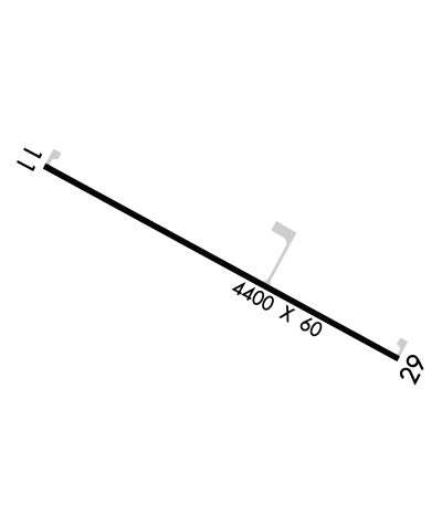
| Lat: N 4157.8 Long: W 10034.2 Elev: 2925 Var: -08 Longest Runway: 4400 | ||
| AWOS: 120.82 CTAF: 122.9 | ||
| ||||||||||||||||||||||||||||||||
| ||||||||||||||||||||||||||||||||
| ||||||||||||||||||||||||||||||||
| Rwy | Rwy | |||||||
| 4400x60 | 4400' | 4400x60 | 4400' | |||||
| Runway ID | Single Wheel | Double Wheel | Double Tandem Wheel | Dual Double Wheel |
| 11/29 | N/A | N/A | N/A | N/A |
| These numbers are Advisory and are not limits. The Airport Manager should have more accurate Weight Limits | ||||
 Airport Diagram might not be current. | |
| Facility Name: | THOMAS COUNTY |
| City Name: | THEDFORD |
| County: | THOMAS |
| State abbrev: | NE |
| State Name: | NEBRASKA |
| Ownership: | PUBLICLY OWNED |
| Use: | OPEN TO THE PUBLIC |
| Owner's Name: | THOMAS COUNTY AIRPORT AUTHORITY |
| Address: | P.O. BOX 22 |
| THEDFORD, NE 69166-0022 | |
| Owner's Phone: | (308) 645-9016; JACK JOHNSTON, CHAIRMAN OF THOMAS COUNTY AIRPORT AUTHORITY; CELL (308) 645-9016 |
| Manager's Name: | JACK JOHNSTON |
| Address: | P.O. BOX 22 |
| THEDFORD, NE 69166-0022 | |
| Phone: | (308) 645-9016 |
| FAA Region: | CENTRAL |
| FAA Field Office: | NONE |
| Date | Sunrise | Sunset |
|---|---|---|
| 09/24/21 Friday | 7:32 | 19:36 |
| 09/25/21 Saturday | 7:33 | 19:35 |
| 09/26/21 Sunday | 7:34 | 19:33 |
| 09/27/21 Monday | 7:35 | 19:31 |
| 09/28/21 Tuesday | 7:36 | 19:29 |
| 09/29/21 Wednesday | 7:37 | 19:28 |
| 09/30/21 Thursday | 7:38 | 19:26 |
| 10/01/21 Friday | 7:39 | 19:24 |
| 10/02/21 Saturday | 7:40 | 19:23 |
| 10/03/21 Sunday | 7:41 | 19:21 |
| 10/04/21 Monday | 7:42 | 19:19 |
| 10/05/21 Tuesday | 7:43 | 19:17 |
| 10/06/21 Wednesday | 7:44 | 19:16 |
| 10/07/21 Thursday | 7:46 | 19:14 |
| Airport Attendance Schedule | UNATTENDED |
| Airport Status | OPERATIONAL (This Status can change at any time - please check NOTAMS) |
| Airport Lighting Schedule | |
| Airport Storage Available | Tie Downs, Hanger |
| Extra Services Available | NONE |
| Wind Indicator | YES - (unlit) |
| Control Tower | NO |
| CTAF Frequency | 122.900 |
| Unicom Frequency | |
| Rotating Beacon Color | CLEAR-GREEN (Light Land Airport) |
| Segmented Circle | NO |
| Landing Fee |
| Airport Inspected | No Inspection Data Available performed by STATE AERONAUTICAL PERSONNEL |
| Inspection Date | 06/11/2020 |
| Type of Fuel Available | Grade 100LL; -10FUEL AVBL 24 HRS WITH CREDIT CARD. |
| Airframe Repair Service | None |
| Power Plant Repair Service | None |
| Latitude | N4157.8 |
| Longitude | W10034.2 (ESTIMATED) |
| Arpt Elevation | 2925ft (SURVEYED) |
| Magnetic Variation | 08E |
| 1 miles S | of THEDFORD |
| Traffic Pattern Altitude | |
| Sectional Chart | OMAHA |
| Operations (Reported) | Yearly | Avg. Daily |
|---|---|---|
| General Aviation Transient | 225 | 1 |
| General Aviation Local | 1500 | 4 |
| Air Taxi | 0 | 0 |
| Commerical | 0 | 0 |
| Commuter | 0 | 0 |
| Military | 2 | 0 |
| Aircraft based on Field | |
|---|---|
| General Aviation Singles | 11 |
| General Aviation Multi | 0 |
| Jet Aircraft | 0 |
| General Aviation Helicopters | 0 |
| Military Aircraft | 0 |
| Gliders | 0 |
| Ultralights | 0 |
| FSS on field | NO |
| FSS tie-in | COLUMBUS |
| FSS Phone | 1-800-WX-BRIEF |
| Who issues Notams | TIF |
| Notam D service at airport | YES |
| ARTCC Name | DENVER |
| Airport Certification | |
| Aircraft Rescue & Firefighting Index | None |
| Airport of Entry | No |
| Custom Landing Rights | No |
| Joint Civil/Military | No |
| Military Landing rights | No |
| NATIONAL PLAN OF INTEGRATED AIRPORT SYSTEMS (NPIAS) |
| COURTESY VAN AVAILABLE |
| FOR CD CTC DENVER ARTCC AT 303-651-4257. |
Airport Communications & Frequencies:
| |||||||
| Runway: 11 | Runway: 29 | ||
| Mag heading: | 110° | Mag heading: | 290° |
| Rwy Slope: | -.34% Down | Rwy Slope: | .34% Up |
| Approach: | Approach: | ||
| Pattern: | Left Traffic | Pattern: | Left Traffic |
| Markings: | NONPRECISION INSTRUMENT | Markings: | NONPRECISION INSTRUMENT |
| Marking Condition: | GOOD | Marking Condition: | GOOD |
| Arresting Dev: | Arresting Dev: | ||
| Lat & Long: | N4157.9 W10034.6 | Lat. & Long.: | N4157.6 W10033.8 |
| Elev: | 2925.0 ft. MSL | Elev: | 2910.2 ft. MSL |
| TCH: | TCH: | ||
| Visual Glide Path: | Visual Glide Path: | ||
| Displaced Threshold: | No | Displaced Threshold: | No |
| Touchdown Zone: | YES | Touchdown Zone: | YES |
| Touchdown Elev.: | 2925.0 feet | Touchdown Elev.: | 2920.3 feet |
| Visual Glide Slope: | Visual Glide Slope: | ||
| RVR Equipment: | RVR Equipment: | ||
| RVV Equipment: | NO | RVV Equipment: | NO |
| Approach Lights: | Approach Lights: | ||
| REIL: | NO | REIL: | NO |
| Centerline Lights: | NO | Centerline Lights: | NO |
| Touchdown lights: | NO | Touchdown lights: | NO |
| Runway Category: | Runway with a Non-precision Approach | Runway Category: | Runway with a Non-precision Approach |
| Declared Distances: | Declared Distances: | ||
| Obstructions: | HILL | Obstructions: | TREES |
| Marked: | NOT Marked/Lighted | Marked: | NOT Marked/Lighted |
| Clearance slope: | 23:1 | Clearance slope: | 23:1 |
| Obstruction height: | 18 feet AGL | Obstruction height: | 24 feet AGL |
| Dist. from runway: | 628 feet | Dist. from runway: | 755 feet |
| Centerline offset: | 230 right of centerline | Centerline offset: | 281 feet right of centerline |
| Comments: | Comments: |
Thanks for using FltPlan.com
all rights reserved © 1999-2021 by Flight Plan LLC
