
| TULLAHOMA REGL/NORTHERN TULLAHOMA TN |
| |
| Lat: N 3522.8 Long: W 08614.8 Elev: 1084 Var: +03 Longest Runway: 5501 | ||
| AWOS: 128.32 CTAF: 123.0 | ||
| ||||||||||||||||||||||||||||||||||||||||||||
| ||||||||||||||||||||||||||||||||||||||||||||
| ||||||||||||||||||||||||||||||||||||||||||||
| Rwy | Rwy | |||||||
| 5501x100 | 5501' | 5501x100 | 5001' | |||||
| 3130x100 | 3130' | 3130x100 | 3130' | |||||
| 4205x100 | 4205' | 110.90 - 182° | 4205x100 | 4205' | ||||
| 2083x100 | 2083' | 2083x100 | 2083' | |||||
| Runway ID | Single Wheel | Double Wheel | Double Tandem Wheel | Dual Double Wheel |
| 06/24 | 76,000 | 100,000 | N/A | N/A |
| 09/27 | N/A | N/A | N/A | N/A |
| 18/36 | 37,000 | N/A | N/A | N/A |
| N/S | N/A | N/A | N/A | N/A |
| These numbers are Advisory and are not limits. The Airport Manager should have more accurate Weight Limits | ||||
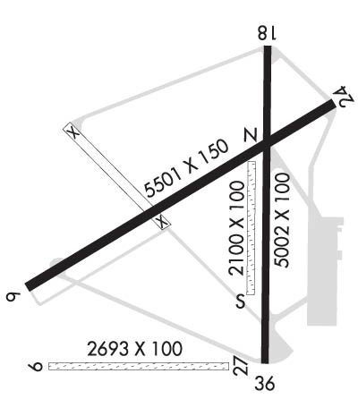 Airport Diagram might not be current. | |
| Facility Name: | TULLAHOMA RGNL/WM NORTHERN FLD |
| City Name: | TULLAHOMA |
| County: | COFFEE |
| State abbrev: | TN |
| State Name: | TENNESSEE |
| Ownership: | PUBLICLY OWNED |
| Use: | OPEN TO THE PUBLIC |
| Owner's Name: | CITY OF TULLAHOMA |
| Address: | BOX 1584 |
| TULLAHOMA, TN 37388 | |
| Owner's Phone: | |
| Manager's Name: | JON GLASS |
| Address: | P.O. BOX 1584 |
| TULLAHOMA, TN 37388 | |
| Phone: | 931-455-3884 |
| FAA Region: | SOUTHERN |
| FAA Field Office: | MEM |
| Date | Sunrise | Sunset |
|---|---|---|
| 06/08/26 Monday | 5:30 | 19:58 |
| 06/09/26 Tuesday | 5:30 | 19:59 |
| 06/10/26 Wednesday | 5:29 | 19:59 |
| 06/11/26 Thursday | 5:29 | 20:00 |
| 06/12/26 Friday | 5:29 | 20:00 |
| 06/13/26 Saturday | 5:29 | 20:01 |
| 06/14/26 Sunday | 5:29 | 20:01 |
| 06/15/26 Monday | 5:29 | 20:02 |
| 06/16/26 Tuesday | 5:29 | 20:02 |
| 06/17/26 Wednesday | 5:30 | 20:02 |
| 06/18/26 Thursday | 5:30 | 20:02 |
| 06/19/26 Friday | 5:30 | 20:03 |
| 06/20/26 Saturday | 5:30 | 20:03 |
| 06/21/26 Sunday | 5:30 | 20:03 |
| Airport Attendance Schedule | 7 Days A Week 0800-1800 |
| Airport Status | OPERATIONAL (This Status can change at any time - please check NOTAMS) |
| Airport Lighting Schedule | ACTVT ODALS RWY 06; PAPI RWY 18 & 36; MIRL RWY 18/36 - CTAF. MIRL RWY 06/24 PRESET TO LOW INTST; INCR INTST - CTAF. |
| Airport Storage Available | Tie Downs, Hanger |
| Extra Services Available | Air Ambulance, Avionics, Charter, Glider, Flight Instruction, Parachute Jumping, Aircraft Rental, Glider Towing |
| Wind Indicator | YES - (unlit) |
| Control Tower | NO |
| CTAF Frequency | 123.000 |
| Unicom Frequency | 123.000 |
| Rotating Beacon Color | WG |
| Segmented Circle | YES |
| Landing Fee | NO |
| Airport Inspected | STATE - performed by STATE AERONAUTICAL PERSONNEL |
| Inspection Date | 05/07/2025 |
| Type of Fuel Available | Grade 100, JET A (freeze point -40C) |
| Airframe Repair Service | MAJOR |
| Power Plant Repair Service | MAJOR |
| Latitude | N3522.8 |
| Longitude | W08614.8 (ESTIMATED) |
| Arpt Elevation | 1084ft (SURVEYED) |
| Magnetic Variation | 03W |
| 2 miles NW | of TULLAHOMA |
| Traffic Pattern Altitude | |
| Sectional Chart | ATLANTA |
| Operations (Reported) | Yearly | Avg. Daily |
|---|---|---|
| General Aviation Transient | 0 | 0 |
| General Aviation Local | 0 | 0 |
| Air Taxi | 0 | 0 |
| Commerical | 0 | 0 |
| Commuter | 0 | 0 |
| Military | 0 | 0 |
| Aircraft based on Field | |
|---|---|
| General Aviation Singles | 0 |
| General Aviation Multi | 0 |
| Jet Aircraft | 0 |
| General Aviation Helicopters | 0 |
| Military Aircraft | 0 |
| Gliders | 0 |
| Ultralights | 0 |
| FSS on field | NO |
| FSS tie-in | NASHVILLE |
| FSS Phone | 1-800-WX-BRIEF |
| Who issues Notams | BNA |
| Notam D service at airport | YES |
| ARTCC Name | MEMPHIS |
| Airport Certification | |
| Aircraft Rescue & Firefighting Index | None |
| Airport of Entry | No |
| Custom Landing Rights | No |
| Joint Civil/Military | No |
| Military Landing rights | YES |
| NATIONAL PLAN OF INTEGRATED AIRPORT SYSTEMS (NPIAS) |
| PAJA, GLIDER OPS, GEESE & DEER ON & INVOF ARPT; PAJA LNDG ZONE E OF PAVED RWY 18/36 MIDFIELD. |
| FOR CD CTC MEMPHIS ARTCC AT 901-368-8453/8449. |
| RWY 09/2 7 FICON SOFT SFC WHEN WET. |
| RWY 24 26:1 TO DTHR. |
| RWY 36 26:1 TO DTHR. |
Airport Communications & Frequencies:
| |||||||||
| Runway: 06 | Runway: 24 | ||
| Mag heading: | 61° | Mag heading: | 241° |
| Rwy Slope: | -.11% Down | Rwy Slope: | .11% Up |
| Approach: | Approach: | ||
| Pattern: | Left Traffic | Pattern: | Left Traffic |
| Markings: | NONPRECISION INSTRUMENT | Markings: | NONPRECISION INSTRUMENT |
| Marking Condition: | GOOD | Marking Condition: | GOOD |
| Arresting Dev: | Arresting Dev: | ||
| Lat & Long: | N3522.7 W08615.3 | Lat. & Long.: | N3523.1 W08614.4 |
| Elev: | 1083.9 ft. MSL | Elev: | 1077.7 ft. MSL |
| TCH: | 41 ft. AGL | TCH: | 33 ft. AGL |
| Visual Glide Path: | 3.00 degrees | Visual Glide Path: | 3.00 degrees |
| Displaced Threshold: | No | Displaced Threshold: | 500 feet |
| Touchdown Zone: | YES | Touchdown Zone: | YES |
| Touchdown Elev.: | 1084.0 feet | Touchdown Elev.: | 1082.2 feet |
| Visual Glide Slope: | 2-Light PAPI on LEFT side of Runway | Visual Glide Slope: | 2-Light PAPI on LEFT side of Runway |
| RVR Equipment: | RVR Equipment: | ||
| RVV Equipment: | NO | RVV Equipment: | NO |
| Approach Lights: | ODALS - omnidirectional approach lighting system | Approach Lights: | |
| REIL: | YES | REIL: | YES |
| Centerline Lights: | NO | Centerline Lights: | NO |
| Touchdown lights: | NO | Touchdown lights: | NO |
| Runway Category: | Runway with a Non-precision Approach having visibility minimums greater than 3/4 mile | Runway Category: | Runway with a Non-precision Approach having visibility minimums greater than 3/4 mile |
| Declared Distances: | Declared Distances: | ||
| Obstructions: | TREE | Obstructions: | TREE |
| Marked: | NOT Marked/Lighted | Marked: | NOT Marked/Lighted |
| Clearance slope: | 19:1 | Clearance slope: | 14:1 |
| Obstruction height: | 44 feet AGL | Obstruction height: | 45 feet AGL |
| Dist. from runway: | 1064 feet | Dist. from runway: | 837 feet |
| Centerline offset: | 181 right of centerline | Centerline offset: | 152 feet left of centerline |
| Comments: | Comments: |
| Runway: 09 | Runway: 27 | ||
| Mag heading: | 92° | Mag heading: | 272° |
| Rwy Slope: | -.06% Down | Rwy Slope: | .06% Up |
| Approach: | Approach: | ||
| Pattern: | Right Traffic | Pattern: | Left Traffic |
| Markings: | BASIC | Markings: | BASIC |
| Marking Condition: | GOOD | Marking Condition: | GOOD |
| Arresting Dev: | Arresting Dev: | ||
| Lat & Long: | N3522.5 W08615.3 | Lat. & Long.: | N3522.5 W08614.7 |
| Elev: | 1077.0 ft. MSL | Elev: | 1075.1 ft. MSL |
| TCH: | TCH: | ||
| Visual Glide Path: | Visual Glide Path: | ||
| Displaced Threshold: | No | Displaced Threshold: | No |
| Touchdown Zone: | YES | Touchdown Zone: | YES |
| Touchdown Elev.: | 1079.3 feet | Touchdown Elev.: | 1079.3 feet |
| Visual Glide Slope: | Visual Glide Slope: | ||
| RVR Equipment: | RVR Equipment: | ||
| RVV Equipment: | NO | RVV Equipment: | NO |
| Approach Lights: | Approach Lights: | ||
| REIL: | NO | REIL: | NO |
| Centerline Lights: | NO | Centerline Lights: | NO |
| Touchdown lights: | NO | Touchdown lights: | NO |
| Runway Category: | Runway with a Visual Approach | Runway Category: | Runway with a Visual Approach |
| Declared Distances: | Declared Distances: | ||
| Obstructions: | TREE | Obstructions: | TREE |
| Marked: | NOT Marked/Lighted | Marked: | NOT Marked/Lighted |
| Clearance slope: | 17:1 | Clearance slope: | 18:1 |
| Obstruction height: | 74 feet AGL | Obstruction height: | 55 feet AGL |
| Dist. from runway: | 1322 feet | Dist. from runway: | 1040 feet |
| Centerline offset: | 209 left of centerline | Centerline offset: | 46 feet left of centerline |
| Comments: | Comments: |
| Runway: 18 | Runway: 36 | ||
| Mag heading: | 183° | Mag heading: | 3° |
| Rwy Slope: | .07% Up | Rwy Slope: | -.07% Down |
| Approach: | SDF | Approach: | |
| Pattern: | Left Traffic | Pattern: | Left Traffic |
| Markings: | NONPRECISION INSTRUMENT | Markings: | NONPRECISION INSTRUMENT |
| Marking Condition: | POOR; FADED & PEELING. | Marking Condition: | POOR; FADED & PEELING. |
| Arresting Dev: | Arresting Dev: | ||
| Lat & Long: | N3523.3 W08614.6 | Lat. & Long.: | N3522.6 W08614.6 |
| Elev: | 1078.8 ft. MSL | Elev: | 1081.7 ft. MSL |
| TCH: | 34 ft. AGL | TCH: | 42 ft. AGL |
| Visual Glide Path: | 2.95 degrees | Visual Glide Path: | 3.00 degrees |
| Displaced Threshold: | No | Displaced Threshold: | No |
| Touchdown Zone: | YES | Touchdown Zone: | YES |
| Touchdown Elev.: | 1082.2 feet | Touchdown Elev.: | 1082.2 feet |
| Visual Glide Slope: | 2-Light PAPI on LEFT side of Runway | Visual Glide Slope: | 2-Light PAPI on LEFT side of Runway; UNUSBL BYD 7 DEGS LEFT AND RIGHT OF CNTRLN. |
| RVR Equipment: | RVR Equipment: | ||
| RVV Equipment: | NO | RVV Equipment: | NO |
| Approach Lights: | Approach Lights: | ||
| REIL: | YES | REIL: | YES |
| Centerline Lights: | NO | Centerline Lights: | NO |
| Touchdown lights: | NO | Touchdown lights: | NO |
| Runway Category: | Runway with a Non-precision Approach having visibility minimums greater than 3/4 mile | Runway Category: | Runway with a Non-precision Approach having visibility minimums greater than 3/4 mile |
| Declared Distances: | Declared Distances: | ||
| Obstructions: | TREE | Obstructions: | TREE |
| Marked: | NOT Marked/Lighted | Marked: | NOT Marked/Lighted |
| Clearance slope: | 16:1 | Clearance slope: | 13:1 |
| Obstruction height: | 80 feet AGL | Obstruction height: | 85 feet AGL |
| Dist. from runway: | 1555 feet | Dist. from runway: | 1359 feet |
| Centerline offset: | 385 right of centerline | Centerline offset: | 351 feet right of centerline |
| Comments: | Comments: |
| Runway: N | Runway: S | ||
| Mag heading: | 3° | Mag heading: | 3° |
| Rwy Slope: | .01% Up | Rwy Slope: | -.01% Down |
| Approach: | Approach: | ||
| Pattern: | Left Traffic | Pattern: | Left Traffic |
| Markings: | Markings: | ||
| Marking Condition: | Marking Condition: | ||
| Arresting Dev: | Arresting Dev: | ||
| Lat & Long: | N3522.6 W08614.7 | Lat. & Long.: | N3523.0 W08614.7 |
| Elev: | 1079.6 ft. MSL | Elev: | 1079.8 ft. MSL |
| TCH: | TCH: | ||
| Visual Glide Path: | Visual Glide Path: | ||
| Displaced Threshold: | No | Displaced Threshold: | No |
| Touchdown Zone: | YES | Touchdown Zone: | YES |
| Touchdown Elev.: | 1079.8 feet | Touchdown Elev.: | 1079.8 feet |
| Visual Glide Slope: | Visual Glide Slope: | ||
| RVR Equipment: | RVR Equipment: | ||
| RVV Equipment: | NO | RVV Equipment: | NO |
| Approach Lights: | Approach Lights: | ||
| REIL: | NO | REIL: | NO |
| Centerline Lights: | NO | Centerline Lights: | NO |
| Touchdown lights: | NO | Touchdown lights: | NO |
| Runway Category: | Runway with a Visual Approach | Runway Category: | Runway with a Visual Approach |
| Declared Distances: | Declared Distances: | ||
| Obstructions: | TREE | Obstructions: | TREE |
| Marked: | NOT Marked/Lighted | Marked: | NOT Marked/Lighted |
| Clearance slope: | 29:1 | Clearance slope: | 28:1 |
| Obstruction height: | 92 feet AGL | Obstruction height: | 77 feet AGL |
| Dist. from runway: | 2713 feet | Dist. from runway: | 2174 feet |
| Centerline offset: | 399 right of centerline | Centerline offset: | 373 feet right of centerline |
| Comments: | Comments: |
Thanks for using FltPlan.com
all rights reserved © 1999-2026 by Flight Plan LLC