
| MC CAMPBELL INGLESIDE TX |
| |
| Lat: N 2754.8 Long: W 09712.7 Elev: 18 Var: -03 Longest Runway: 4999 | ||
| AWOS: 118.77 CTAF: 122.7 | ||
| ||||||
| ||||||
|
| Rwy | Rwy | |||||||
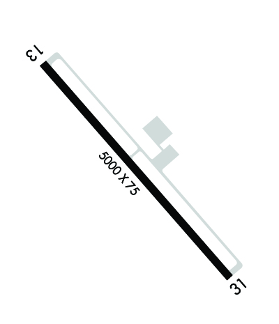
| 4999x75 | 4999' | 4999x75 | 4999' | |||||
| Runway ID | Single Wheel | Double Wheel | Double Tandem Wheel | Dual Double Wheel |
| 14/32 | N/A | N/A | N/A | N/A |
| These numbers are Advisory and are not limits. The Airport Manager should have more accurate Weight Limits | ||||
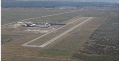
 Airport Diagram might not be current. | |
| Facility Name: | INGLESIDE RGNL |
| City Name: | INGLESIDE |
| County: | SAN PATRICIO |
| State abbrev: | TX |
| State Name: | TEXAS |
| Ownership: | PUBLICLY OWNED |
| Use: | OPEN TO THE PUBLIC |
| Owner's Name: | SAN PATRICIO COUNTY |
| Address: | 400 WEST SINTON ST. |
| SINTON, TX 78387 | |
| Owner's Phone: | 361-364-9303 |
| Manager's Name: | GARY LEE DAVIS |
| Address: | 3141 FM 3512 |
| ARANSAS PASS, TX 78336 | |
| Phone: | 361-226-0112; 317-410-0724 |
| FAA Region: | SOUTHWEST |
| FAA Field Office: | TEX |
| Date | Sunrise | Sunset |
|---|---|---|
| 06/12/26 Friday | 6:32 | 20:25 |
| 06/13/26 Saturday | 6:32 | 20:26 |
| 06/14/26 Sunday | 6:32 | 20:26 |
| 06/15/26 Monday | 6:32 | 20:26 |
| 06/16/26 Tuesday | 6:32 | 20:27 |
| 06/17/26 Wednesday | 6:32 | 20:27 |
| 06/18/26 Thursday | 6:33 | 20:27 |
| 06/19/26 Friday | 6:33 | 20:28 |
| 06/20/26 Saturday | 6:33 | 20:28 |
| 06/21/26 Sunday | 6:33 | 20:28 |
| 06/22/26 Monday | 6:33 | 20:28 |
| 06/23/26 Tuesday | 6:34 | 20:28 |
| 06/24/26 Wednesday | 6:34 | 20:29 |
| 06/25/26 Thursday | 6:34 | 20:29 |
| Airport Attendance Schedule | MON-FRI 0800-1630, SAT-SUN 0800-1600 |
| Airport Status | OPERATIONAL (This Status can change at any time - please check NOTAMS) |
| Airport Lighting Schedule | MIRL RWY 14/32 PRESET LOW INTST; TO INCR INTST ACTVT - CTAF. |
| Airport Storage Available | Tie Downs, Hanger |
| Extra Services Available | Flight Instruction |
| Wind Indicator | YES - (lighted) |
| Control Tower | NO |
| CTAF Frequency | 122.700 |
| Unicom Frequency | 122.700 |
| Rotating Beacon Color | WG |
| Segmented Circle | YES |
| Landing Fee |
| Airport Inspected | STATE - performed by PRIVATE CONTRACT PERSONNEL |
| Inspection Date | 01/10/2026 |
| Type of Fuel Available | Grade 100LL, JET A; -10FUEL: FULL SERV & SELF SERVE. |
| Airframe Repair Service | MAJOR |
| Power Plant Repair Service | MAJOR |
| Latitude | N2754.8 |
| Longitude | W09712.7 (ESTIMATED) |
| Arpt Elevation | 17ft (SURVEYED) |
| Magnetic Variation | 03E |
| 2 miles N | of INGLESIDE |
| Traffic Pattern Altitude | |
| Sectional Chart | BROWNSVILLE |
| Operations (Reported) | Yearly | Avg. Daily |
|---|---|---|
| General Aviation Transient | 0 | 0 |
| General Aviation Local | 0 | 0 |
| Air Taxi | 0 | 0 |
| Commerical | 0 | 0 |
| Commuter | 0 | 0 |
| Military | 0 | 0 |
| Aircraft based on Field | |
|---|---|
| General Aviation Singles | 0 |
| General Aviation Multi | 0 |
| Jet Aircraft | 0 |
| General Aviation Helicopters | 0 |
| Military Aircraft | 0 |
| Gliders | 0 |
| Ultralights | 0 |
| FSS on field | NO |
| FSS tie-in | SAN ANGELO |
| FSS Phone | 1-800-WX-BRIEF |
| Who issues Notams | SJT |
| Notam D service at airport | YES |
| ARTCC Name | HOUSTON |
| Airport Certification | |
| Aircraft Rescue & Firefighting Index | None |
| Airport of Entry | No |
| Custom Landing Rights | No |
| Joint Civil/Military | No |
| Military Landing rights | No |
| NATIONAL PLAN OF INTEGRATED AIRPORT SYSTEMS (NPIAS) |
| ASSURANCES PURSUANT TO TITLE VI, CIVIL RIGHTS ACT OF 1964 |
| GRANT AGREEMENT HAS EXPIRED; HOWEVER, AGREEMENT REMAINS IN EFFECT FOR THIS FACILITY AS LONG AS IT IS PUBLIC USE. |
| FOR CD CTC CORPUS CHRISTI APCH AT 361-299-4230. |
Airport Communications & Frequencies:
| ||||||||||||||
| Runway: 14 | Runway: 32 | ||
| Mag heading: | 137° | Mag heading: | 317° |
| Rwy Slope: | -.04% Down | Rwy Slope: | .04% Up |
| Approach: | Approach: | ||
| Pattern: | Left Traffic | Pattern: | Left Traffic |
| Markings: | NONPRECISION INSTRUMENT | Markings: | NONPRECISION INSTRUMENT |
| Marking Condition: | GOOD; NORTH END OF RWY CNTRLN MKG POOR. | Marking Condition: | GOOD |
| Arresting Dev: | Arresting Dev: | ||
| Lat & Long: | N2755.1 W09713.0 | Lat. & Long.: | N2754.5 W09712.4 |
| Elev: | 15.0 ft. MSL | Elev: | 13.2 ft. MSL |
| TCH: | 39 ft. AGL | TCH: | 33 ft. AGL |
| Visual Glide Path: | 3.00 degrees | Visual Glide Path: | 3.00 degrees |
| Displaced Threshold: | No | Displaced Threshold: | No |
| Touchdown Zone: | YES | Touchdown Zone: | YES |
| Touchdown Elev.: | 17.7 feet | Touchdown Elev.: | 17.7 feet |
| Visual Glide Slope: | 2-Light PAPI on LEFT side of Runway | Visual Glide Slope: | 2-Light PAPI on LEFT side of Runway |
| RVR Equipment: | RVR Equipment: | ||
| RVV Equipment: | NO | RVV Equipment: | NO |
| Approach Lights: | Approach Lights: | ||
| REIL: | YES | REIL: | YES |
| Centerline Lights: | NO | Centerline Lights: | NO |
| Touchdown lights: | NO | Touchdown lights: | NO |
| Runway Category: | Runway with a Non-precision Approach having visibility minimums greater than 3/4 mile | Runway Category: | Runway with a Non-precision Approach having visibility minimums greater than 3/4 mile |
| Declared Distances: | Declared Distances: |
Thanks for using FltPlan.com
all rights reserved © 1999-2026 by Flight Plan LLC