
| TETERBORO TETERBORO NJ |
| |
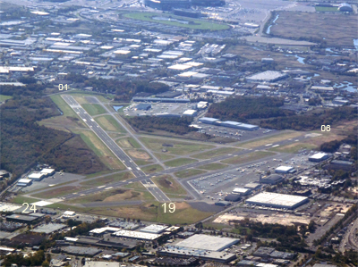
| Lat: N 4051.0 Long: W 07403.7 Elev: 8 Var: +12 Longest Runway: 6997 | ||
| Clr Del: 128.05 Dept. ATIS: 114.2 Arr. ATIS: 114.2/132.85 Ground: 121.9 Tower: 119.5/125.1 | ||

| |||||||||||||||||||||||||||||||||||||||||||||||||||||||||||||||||||||
| |||||||||||||||||||||||||||||||||||||||||||||||||||||||||||||||||||||
| |||||||||||||||||||||||||||||||||||||||||||||||||||||||||||||||||||||
| |||||||||||||||||||||||||||||||||||||||||||||||||||||||||||||||||||||
| |||||||||||||||||||||||||||||||||||||||||||||||||||||||||||||||||||||
| |||||||||||||||||||||||||||||||||||||||||||||||||||||||||||||||||||||
| |||||||||||||||||||||||||||||||||||||||||||||||||||||||||||||||||||||
| Rwy | Rwy | |||||||
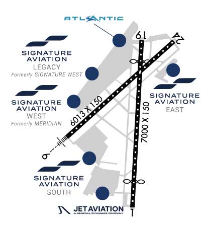
| 6997x150 | 6227' | 6997x150 | 6230' | 110.15 - 195° | ||||
| 6014x150 | 6014' | 111.75 - 060° | 6014x150 | 6014' | ||||
| Runway ID | Single Wheel | Double Wheel | Double Tandem Wheel | Dual Double Wheel |
| 01/19 | 50,000 | 100,000 | N/A | N/A |
| 06/24 | 50,000 | 100,000 | N/A | N/A |
| These numbers are Advisory and are not limits. The Airport Manager should have more accurate Weight Limits | ||||
 Airport Diagram might not be current. | |
| Facility Name: | TETERBORO |
| City Name: | TETERBORO |
| County: | BERGEN |
| State abbrev: | NJ |
| State Name: | NEW JERSEY |
| Ownership: | PUBLICLY OWNED |
| Use: | OPEN TO THE PUBLIC |
| Owner's Name: | PORT AUTHORITY OF NY & NJ |
| Address: | 4 WORLD TRADE CENTER |
| NEW YORK, NY 10006 | |
| Owner's Phone: | 212-435-3640 |
| Manager's Name: | SHERRI SMITH |
| Address: | 90 MOONACHIE AVE |
| TETERBORO, NJ 07608 | |
| Phone: | 201-807-4019 |
| FAA Region: | EASTERN |
| FAA Field Office: | NYC |
| Date | Sunrise | Sunset |
|---|---|---|
| 06/08/26 Monday | 5:25 | 20:26 |
| 06/09/26 Tuesday | 5:24 | 20:27 |
| 06/10/26 Wednesday | 5:24 | 20:27 |
| 06/11/26 Thursday | 5:24 | 20:28 |
| 06/12/26 Friday | 5:24 | 20:28 |
| 06/13/26 Saturday | 5:24 | 20:29 |
| 06/14/26 Sunday | 5:24 | 20:29 |
| 06/15/26 Monday | 5:24 | 20:29 |
| 06/16/26 Tuesday | 5:24 | 20:30 |
| 06/17/26 Wednesday | 5:24 | 20:30 |
| 06/18/26 Thursday | 5:24 | 20:31 |
| 06/19/26 Friday | 5:24 | 20:31 |
| 06/20/26 Saturday | 5:24 | 20:31 |
| 06/21/26 Sunday | 5:25 | 20:31 |
| Airport Attendance Schedule | CONTINUOUS |
| Airport Status | OPERATIONAL (This Status can change at any time - please check NOTAMS) |
| Airport Lighting Schedule | SS-SR |
| Airport Storage Available | Tie Downs, Hanger |
| Extra Services Available | Avionics, Cargo Handling, Charter, Aircraft Sales |
| Wind Indicator | YES - (lighted) |
| Control Tower | YES |
| CTAF Frequency | |
| Unicom Frequency | ARPT OPS FREQUENCY 130.575. |
| Rotating Beacon Color | WG |
| Segmented Circle | NO |
| Landing Fee | YES |
| Airport Inspected | FEDERAL - performed by FAA AIRPORTS FIELD PERSONNEL |
| Inspection Date | 10/28/2025 |
| Type of Fuel Available | Grade 100LL, JET A (freeze point -40C) |
| Airframe Repair Service | MAJOR |
| Power Plant Repair Service | MAJOR |
| Latitude | N4051.0 |
| Longitude | W07403.7 (ESTIMATED) |
| Arpt Elevation | 8ft (SURVEYED) |
| Magnetic Variation | 12W |
| 1 miles SW | of TETERBORO |
| Traffic Pattern Altitude | TPA 1500 FT MSL FOR LARGE/TURBINE ACFT; 1000 FT MSL FOR ALL OTHERS. |
| Sectional Chart | NEW YORK |
| Operations (Reported) | Yearly | Avg. Daily |
|---|---|---|
| General Aviation Transient | 0 | 0 |
| General Aviation Local | 0 | 0 |
| Air Taxi | 0 | 0 |
| Commerical | 0 | 0 |
| Commuter | 0 | 0 |
| Military | 0 | 0 |
| Aircraft based on Field | |
|---|---|
| General Aviation Singles | 0 |
| General Aviation Multi | 0 |
| Jet Aircraft | 0 |
| General Aviation Helicopters | 0 |
| Military Aircraft | 0 |
| Gliders | 0 |
| Ultralights | 0 |
| FSS on field | NO |
| FSS tie-in | MILLVILLE |
| FSS Phone | 1-800-WX-BRIEF |
| Who issues Notams | TEB |
| Notam D service at airport | YES |
| ARTCC Name | NEW YORK |
| Airport Certification | ARFF INDEX B EQUIPMENT COVERAGE PRVDD. |
| Aircraft Rescue & Firefighting Index | AIRPORT HAS A CERTIFICATE UNDER CFR PART 139 |
| Airport of Entry | No |
| Custom Landing Rights | YES |
| Joint Civil/Military | No |
| Military Landing rights | YES |
| NATIONAL PLAN OF INTEGRATED AIRPORT SYSTEMS (NPIAS) |
| GRANT AGREEMENTS UNDER FAAP/ADAP/AIP |
| ASSURANCES PURSUANT TO TITLE VI, CIVIL RIGHTS ACT OF 1964 |
| CLSD TO MOTORLESS ACFT - UNCTLD ACFT & ULTRALIGHT ACTIVITY EXCEP BY PRIOR PERMISSION. |
| DLY CONS CONST ACT ALL QUADRANTS. |
| ACFT CAPABLE OF OPERATING ABV 100,000 POUNDS MUST SUBMIT CERTIFICATION TO AMGR VERIFYING AIRCRAFT OPERATING WEIGHT IS LESS THAN 100,000 LBS. CONTACT AIRPORT OPERATIONS AT 201-288-1775 FOR FORMS. |
| TEB RNAV (GPS) X RWY 06 IS PRIM RNAV APCH TO RWY 06. |
| ALL ACFT AVOID HOSPITAL 1.7 MILE NORTH OF RWY 01/19. |
| DEER AND BIRD ACT ON AND INVOF ARPT. |
| HEL OPNS OVER RESIDENTIAL AREAS BLO 1000 FT MSL SHOULD BE AVOIDED. |
| ACFT & HELICOPTER NOISE ABATEMENT RULES IN EFF; CTC ARPT NOISE ABATEMENT OFC 201-393-0399/288-1775 FOR COPY OF PROCEDURES & RULES PRIOR TO ARR. RY 24 NOISE CRITICAL RY MAX NOISE LIMIT OF 80 DB BETWEEN 2200-0700 & 90 DB ALL OTR HRS. |
| STAGE 1 ACFT NOT PERMITTED TO OPR AT TETERBORO ARPT. |
| RWY 01/1 9 PCR VALUE: 459/F/D/X/T |
| RWY 06/2 4 PCR VALUE: 343/F/D/X/T |
Airport Communications & Frequencies:
| |||||||||||||||||||||||||||||||||||
| Runway: 01 | Runway: 19 | ||
| Mag heading: | 15° | Mag heading: | 195° |
| Rwy Slope: | -.03% Down | Rwy Slope: | .03% Up |
| Approach: | Approach: | ILS/DME | |
| Pattern: | Left Traffic | Pattern: | Left Traffic |
| Markings: | PRECISION INSTRUMENT | Markings: | PRECISION INSTRUMENT |
| Marking Condition: | GOOD | Marking Condition: | GOOD |
| Arresting Dev: | Arresting Dev: | EMAS; ENGINEERED MATERIALS ARRESTING SYSTEM (EMAS) 355 FT IN LENGTH BY 162 FT WIDTH LCTD AT DEP END RWY 19. | |
| Lat & Long: | N4050.3 W07403.6 | Lat. & Long.: | N4051.5 W07403.5 |
| Elev: | 8.3 ft. MSL | Elev: | 6.3 ft. MSL |
| TCH: | 56 ft. AGL | TCH: | 57 ft. AGL |
| Visual Glide Path: | 3.10 degrees | Visual Glide Path: | 3.00 degrees |
| Displaced Threshold: | 770 feet | Displaced Threshold: | 767 feet |
| Touchdown Zone: | YES | Touchdown Zone: | YES |
| Touchdown Elev.: | 8.3 feet | Touchdown Elev.: | 5.9 feet |
| Visual Glide Slope: | 4-Light PAPI on LEFT side of Runway | Visual Glide Slope: | 4-Light PAPI on LEFT side of Runway |
| RVR Equipment: | RVR Equipment: | ||
| RVV Equipment: | NO | RVV Equipment: | NO |
| Approach Lights: | Approach Lights: | ||
| REIL: | YES | REIL: | YES |
| Centerline Lights: | YES; RWY 01/19 DTHR CNTRLN LGTS OTS INDEFLY. | Centerline Lights: | YES |
| Touchdown lights: | NO | Touchdown lights: | YES |
| Runway Category: | Runway with a Visual Approach | Runway Category: | Precision Instrument Runway |
| Declared Distances: | TORA:6997' TODA:6997' ASDA:6929' LDA:6159' | Declared Distances: | TORA:6997' TODA:6997' ASDA:6997' LDA:6230' |
| Obstructions: | TREE | Obstructions: | BLDG |
| Marked: | NOT Marked/Lighted | Marked: | LIGHTED |
| Clearance slope: | 7:1; RWY 01 67 FT TREE DIST 1200 FT, 400 FT RIGHT, 16:1 BASED ON DTHR. | Clearance slope: | 34:1; RWY 19 APCH RATIO 25:1 TO DTHR. |
| Obstruction height: | 88 feet AGL | Obstruction height: | 263 feet AGL |
| Dist. from runway: | 802 feet | Dist. from runway: | 9256 feet |
| Centerline offset: | 524 left of centerline | Centerline offset: | 319 feet left of centerline |
| Comments: | Comments: |
| Runway: 06 | Runway: 24 | ||
| Mag heading: | 60° | Mag heading: | 240° |
| Rwy Slope: | .03% Up | Rwy Slope: | -.03% Down |
| Approach: | ILS/DME | Approach: | |
| Pattern: | Left Traffic | Pattern: | Left Traffic |
| Markings: | PRECISION INSTRUMENT | Markings: | PRECISION INSTRUMENT |
| Marking Condition: | GOOD | Marking Condition: | GOOD |
| Arresting Dev: | EMAS; EMAS NON-STD ARRESTING GEAR/SYSTEM: ENGINEERED MATERIALS ARRESTING SYSTEM (EMAS) 250 FT IN LENGTH BY 170 FT WIDTH LCTD AT DEP END RWY 06. | Arresting Dev: | EMAS; ENGINEERED MATERIALS ARRESTING SYSTEM (EMAS) 348 FT IN LENGTH BY 162 FT WIDTH LCTD AT DEP END RWY 24. |
| Lat & Long: | N4050.8 W07404.2 | Lat. & Long.: | N4051.5 W07403.2 |
| Elev: | 4.8 ft. MSL | Elev: | 6.7 ft. MSL |
| TCH: | TCH: | 46 ft. AGL | |
| Visual Glide Path: | Visual Glide Path: | 3.20 degrees | |
| Displaced Threshold: | No | Displaced Threshold: | No |
| Touchdown Zone: | YES | Touchdown Zone: | YES |
| Touchdown Elev.: | 4.9 feet | Touchdown Elev.: | 6.8 feet |
| Visual Glide Slope: | Visual Glide Slope: | 4-Light PAPI on LEFT side of Runway | |
| RVR Equipment: | TOUCHDOWN-ROLLOUT | RVR Equipment: | TOUCHDOWN-ROLLOUT |
| RVV Equipment: | NO | RVV Equipment: | NO |
| Approach Lights: | MALSR - 1,400 foot medium intensity approach lighting system with runway alignment indicator lights | Approach Lights: | |
| REIL: | YES | REIL: | YES |
| Centerline Lights: | YES | Centerline Lights: | YES |
| Touchdown lights: | YES | Touchdown lights: | NO |
| Runway Category: | Precision Instrument Runway | Runway Category: | Runway with a Non-precision Approach having visibility minimums greater than 3/4 mile |
| Declared Distances: | TORA:6014' TODA:6014' ASDA:6014' LDA:6014' | Declared Distances: | TORA:6014' TODA:6014' ASDA:6014' LDA:6014' |
| Obstructions: | TREE | Obstructions: | TREE |
| Marked: | NOT Marked/Lighted | Marked: | NOT Marked/Lighted |
| Clearance slope: | 38:1 | Clearance slope: | 19:1 |
| Obstruction height: | 148 feet AGL | Obstruction height: | 77 feet AGL |
| Dist. from runway: | 5950 feet | Dist. from runway: | 1705 feet |
| Centerline offset: | 1293 left of centerline | Centerline offset: | 462 feet left of centerline |
| Comments: | Comments: |
Thanks for using FltPlan.com
all rights reserved © 1999-2026 by Flight Plan LLC