
| TOLEDO EXECUTIVE AIRPORT TOLEDO OH |
| |
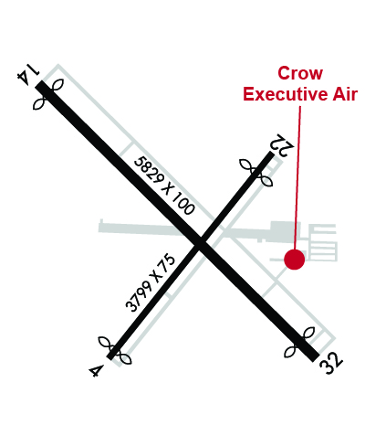
| Lat: N 4133.9 Long: W 08328.9 Elev: 623 Var: +07 Longest Runway: 5829 | ||
| Clr Del: 125.6 AWOS: 121.57 CTAF: 123.05 | ||
| ||||||||||||||||||||||||||||||||||||||||||||
| ||||||||||||||||||||||||||||||||||||||||||||
| ||||||||||||||||||||||||||||||||||||||||||||
| Rwy | Rwy | |||||||
| 3799x75 | 3699' | 3799x75 | 3419' | |||||
| 5829x100 | 5604' | 5829x100 | 5478' | |||||
| Runway ID | Single Wheel | Double Wheel | Double Tandem Wheel | Dual Double Wheel |
| 04/22 | 63,000 | 85,000 | N/A | N/A |
| 14/32 | 63,000 | 85,000 | N/A | N/A |
| These numbers are Advisory and are not limits. The Airport Manager should have more accurate Weight Limits | ||||
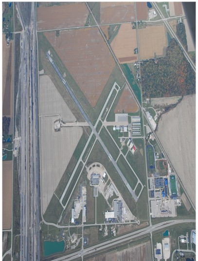
 Airport Diagram might not be current. | |
| Facility Name: | TOLEDO EXEC |
| City Name: | TOLEDO |
| County: | WOOD |
| State abbrev: | OH |
| State Name: | OHIO |
| Ownership: | PUBLICLY OWNED |
| Use: | OPEN TO THE PUBLIC |
| Owner's Name: | TOLEDO LUCAS COUNTY PORT AUTHORITY |
| Address: | 1 MARITIME PLZ |
| TOLEDO, OH 43604-1893 | |
| Owner's Phone: | 419-243-8251 |
| Manager's Name: | CHRIS CURRY |
| Address: | 11013 AIRPORT HWY STE 11; ARPT PHYS ADS: 28331 LEMOYNE RD, MILLBURY, OH 43447. |
| SWANTON, OH 43558-9403 | |
| Phone: | 419-243-8251 |
| FAA Region: | GREAT LAKES |
| FAA Field Office: | DET |
| Date | Sunrise | Sunset |
|---|---|---|
| 06/08/26 Monday | 6:00 | 21:06 |
| 06/09/26 Tuesday | 6:00 | 21:07 |
| 06/10/26 Wednesday | 6:00 | 21:07 |
| 06/11/26 Thursday | 5:59 | 21:08 |
| 06/12/26 Friday | 5:59 | 21:08 |
| 06/13/26 Saturday | 5:59 | 21:09 |
| 06/14/26 Sunday | 5:59 | 21:09 |
| 06/15/26 Monday | 5:59 | 21:10 |
| 06/16/26 Tuesday | 5:59 | 21:10 |
| 06/17/26 Wednesday | 5:59 | 21:10 |
| 06/18/26 Thursday | 5:59 | 21:11 |
| 06/19/26 Friday | 6:00 | 21:11 |
| 06/20/26 Saturday | 6:00 | 21:11 |
| 06/21/26 Sunday | 6:00 | 21:11 |
| Airport Attendance Schedule | MON-SAT 0800-1800, SUN 0800-1700 |
| Airport Status | OPERATIONAL (This Status can change at any time - please check NOTAMS) |
| Airport Lighting Schedule | ACTVT REIL RWY 04, 22, & 14; PAPI RWY 04, 22, 14, & 32; MIRL RWY 04/22 & 14/32 - CTAF. |
| Airport Storage Available | Tie Downs, Hanger |
| Extra Services Available | Air Freight, Cargo Handling, Flight Instruction, Aircraft Rental, Aircraft Sales |
| Wind Indicator | YES - (lighted) |
| Control Tower | NO |
| CTAF Frequency | 123.050 |
| Unicom Frequency | 123.050 |
| Rotating Beacon Color | WG |
| Segmented Circle | NO |
| Landing Fee | YES |
| Airport Inspected | STATE - performed by STATE AERONAUTICAL PERSONNEL |
| Inspection Date | 06/24/2025 |
| Type of Fuel Available | Grade 100LL, JET A (freeze point -40C); -A JET A AVBL SELF SVC OR FULL SVC.; -10100LL AVBL SELF SVC OR FULL SVC. |
| Airframe Repair Service | MAJOR |
| Power Plant Repair Service | MAJOR |
| Latitude | N4133.9 |
| Longitude | W08328.9 (ESTIMATED) |
| Arpt Elevation | 622ft (SURVEYED) |
| Magnetic Variation | 07W |
| 6 miles SE | of TOLEDO |
| Traffic Pattern Altitude | |
| Sectional Chart | DETROIT |
| Operations (Reported) | Yearly | Avg. Daily |
|---|---|---|
| General Aviation Transient | 0 | 0 |
| General Aviation Local | 0 | 0 |
| Air Taxi | 0 | 0 |
| Commerical | 0 | 0 |
| Commuter | 0 | 0 |
| Military | 0 | 0 |
| Aircraft based on Field | |
|---|---|
| General Aviation Singles | 0 |
| General Aviation Multi | 0 |
| Jet Aircraft | 0 |
| General Aviation Helicopters | 0 |
| Military Aircraft | 0 |
| Gliders | 0 |
| Ultralights | 0 |
| FSS on field | NO |
| FSS tie-in | CLEVELAND |
| FSS Phone | 1-800-WX-BRIEF |
| Who issues Notams | TDZ |
| Notam D service at airport | YES |
| ARTCC Name | CLEVELAND |
| Airport Certification | |
| Aircraft Rescue & Firefighting Index | None |
| Airport of Entry | No |
| Custom Landing Rights | No |
| Joint Civil/Military | No |
| Military Landing rights | YES |
| NATIONAL PLAN OF INTEGRATED AIRPORT SYSTEMS (NPIAS) |
| GRANT AGREEMENTS UNDER FAAP/ADAP/AIP |
| ASSURANCES PURSUANT TO TITLE VI, CIVIL RIGHTS ACT OF 1964 |
| PARL TWY RWY 04/22 & 14/32 35 FT WID. |
| DEER & COYOTES ON & INVOF ARPT. |
| FOR CD CTC TOLEDO APCH AT 419-865-1495. |
Airport Communications & Frequencies:
| |||||||||||||||||||
| Runway: 04 | Runway: 22 | ||
| Mag heading: | 46° | Mag heading: | 226° |
| Rwy Slope: | -.06% Down | Rwy Slope: | .06% Up |
| Approach: | Approach: | ||
| Pattern: | Left Traffic | Pattern: | Left Traffic |
| Markings: | NONPRECISION INSTRUMENT | Markings: | NONPRECISION INSTRUMENT |
| Marking Condition: | GOOD | Marking Condition: | GOOD |
| Arresting Dev: | Arresting Dev: | ||
| Lat & Long: | N4133.6 W08329.2 | Lat. & Long.: | N4134.1 W08328.7 |
| Elev: | 622.7 ft. MSL | Elev: | 620.5 ft. MSL |
| TCH: | 35 ft. AGL | TCH: | 25 ft. AGL |
| Visual Glide Path: | 3.50 degrees | Visual Glide Path: | 3.00 degrees |
| Displaced Threshold: | 100 feet | Displaced Threshold: | 380 feet |
| Touchdown Zone: | YES | Touchdown Zone: | YES |
| Touchdown Elev.: | 622.7 feet | Touchdown Elev.: | 622.5 feet |
| Visual Glide Slope: | 4-Light PAPI on LEFT side of Runway | Visual Glide Slope: | 4-Light PAPI on LEFT side of Runway |
| RVR Equipment: | RVR Equipment: | ||
| RVV Equipment: | NO | RVV Equipment: | NO |
| Approach Lights: | Approach Lights: | ||
| REIL: | YES | REIL: | YES |
| Centerline Lights: | NO | Centerline Lights: | NO |
| Touchdown lights: | NO | Touchdown lights: | NO |
| Runway Category: | Runway with a Non-precision Approach | Runway Category: | Runway with a Visual Approach |
| Declared Distances: | Declared Distances: | ||
| Obstructions: | ROAD | Obstructions: | RR |
| Marked: | NOT Marked/Lighted | Marked: | NOT Marked/Lighted |
| Clearance slope: | 14:1; APCH RATIO 20:1 TO DTHR. | Clearance slope: | 6:1; APCH RATIO 20:1 TO DTHR. |
| Obstruction height: | 15 feet AGL | Obstruction height: | 29 feet AGL |
| Dist. from runway: | 412 feet | Dist. from runway: | 393 feet |
| Centerline offset: | 280 right of centerline | Centerline offset: | 144 feet left of centerline |
| Comments: | Comments: |
| Runway: 14 | Runway: 32 | ||
| Mag heading: | 141° | Mag heading: | 321° |
| Rwy Slope: | -.01% Down | Rwy Slope: | .01% Up |
| Approach: | Approach: | ||
| Pattern: | Left Traffic | Pattern: | Left Traffic |
| Markings: | NONPRECISION INSTRUMENT | Markings: | NONPRECISION INSTRUMENT |
| Marking Condition: | FAIR | Marking Condition: | FAIR |
| Arresting Dev: | Arresting Dev: | ||
| Lat & Long: | N4134.3 W08329.4 | Lat. & Long.: | N4133.6 W08328.5 |
| Elev: | 621.8 ft. MSL | Elev: | 621.0 ft. MSL |
| TCH: | 45 ft. AGL | TCH: | 45 ft. AGL |
| Visual Glide Path: | 3.00 degrees | Visual Glide Path: | 3.00 degrees |
| Displaced Threshold: | 225 feet | Displaced Threshold: | 351 feet |
| Touchdown Zone: | YES | Touchdown Zone: | YES |
| Touchdown Elev.: | 621.6 feet | Touchdown Elev.: | 621.4 feet |
| Visual Glide Slope: | 4-Light PAPI on LEFT side of Runway | Visual Glide Slope: | 4-Light PAPI on LEFT side of Runway |
| RVR Equipment: | RVR Equipment: | ||
| RVV Equipment: | NO | RVV Equipment: | NO |
| Approach Lights: | Approach Lights: | ||
| REIL: | YES | REIL: | NO |
| Centerline Lights: | NO | Centerline Lights: | NO |
| Touchdown lights: | NO | Touchdown lights: | NO |
| Runway Category: | Runway with a Visual Approach | Runway Category: | Runway with a Non-precision Approach |
| Declared Distances: | TORA:5829' TODA:5829' ASDA:5182' LDA:4957' | Declared Distances: | TORA:5829' TODA:5829' ASDA:5278' LDA:4927' |
| Obstructions: | TOWER | Obstructions: | ROAD |
| Marked: | NOT Marked/Lighted | Marked: | NOT Marked/Lighted |
| Clearance slope: | 11:1; APCH RATIO 20:1 TO DTHR. | Clearance slope: | 8:1; APCH RATIO 17:1 TO DTHR OVR +31 FT TREE, 538 FT DIST, 299 FT L. |
| Obstruction height: | 45 feet AGL | Obstruction height: | 17 feet AGL |
| Dist. from runway: | 709 feet | Dist. from runway: | 352 feet |
| Centerline offset: | 163 right of centerline | Centerline offset: | 273 feet right of centerline |
| Comments: | Comments: |
Thanks for using FltPlan.com
all rights reserved © 1999-2026 by Flight Plan LLC