
| RALEIGH RGNL AT PERSON COUNTY ROXBORO NC |
| |
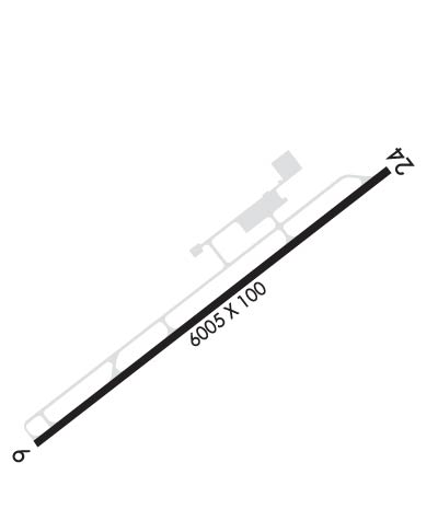
| Lat: N 3617.1 Long: W 07859.1 Elev: 609 Var: +08 Longest Runway: 6005 | ||
| AWOS: 126.72 CTAF: 122.7 | ||
| ||||||||||||||||||||||||||||||||||||||||||||
| ||||||||||||||||||||||||||||||||||||||||||||
| ||||||||||||||||||||||||||||||||||||||||||||
| Rwy | Rwy | |||||||
| 6005x100 | 5702' | 108.70 - 060° | 6005x100 | 6005' | ||||
| Runway ID | Single Wheel | Double Wheel | Double Tandem Wheel | Dual Double Wheel |
| 06/24 | 45,000 | 68,000 | N/A | N/A |
| These numbers are Advisory and are not limits. The Airport Manager should have more accurate Weight Limits | ||||
 Airport Diagram might not be current. | |
| Facility Name: | RALEIGH RGNL AT PERSON COUNTY |
| City Name: | ROXBORO |
| County: | PERSON |
| State abbrev: | NC |
| State Name: | NORTH CAROLINA |
| Ownership: | PUBLICLY OWNED |
| Use: | OPEN TO THE PUBLIC |
| Owner's Name: | PERSON COUNTY |
| Address: | COUNTY BLDG, 304 S MORGAN ST |
| ROXBORO, NC 27573-5245 | |
| Owner's Phone: | 336-597-1735 |
| Manager's Name: | BILL TOUGAS |
| Address: | 385 MONTGOMERY DRIVE |
| TIMBERLAKE, NC 27583-5245 | |
| Phone: | 336-364-1111 |
| FAA Region: | SOUTHERN |
| FAA Field Office: | MEM |
| Date | Sunrise | Sunset |
|---|---|---|
| 06/08/26 Monday | 5:58 | 20:32 |
| 06/09/26 Tuesday | 5:58 | 20:32 |
| 06/10/26 Wednesday | 5:58 | 20:33 |
| 06/11/26 Thursday | 5:58 | 20:33 |
| 06/12/26 Friday | 5:58 | 20:34 |
| 06/13/26 Saturday | 5:58 | 20:34 |
| 06/14/26 Sunday | 5:58 | 20:35 |
| 06/15/26 Monday | 5:58 | 20:35 |
| 06/16/26 Tuesday | 5:58 | 20:35 |
| 06/17/26 Wednesday | 5:58 | 20:36 |
| 06/18/26 Thursday | 5:58 | 20:36 |
| 06/19/26 Friday | 5:58 | 20:36 |
| 06/20/26 Saturday | 5:58 | 20:37 |
| 06/21/26 Sunday | 5:59 | 20:37 |
| Airport Attendance Schedule | 7 Days A Week 0900-1700; ARPT UNATNDD THANKSGIVING & CHRISTMAS. |
| Airport Status | OPERATIONAL (This Status can change at any time - please check NOTAMS) |
| Airport Lighting Schedule | REIL RWY 24; MIRL RWY 06/24 OPR SS-SR; TO ACTVT OTR TIMES AND ACTVT MALSR RWY 06; PAPI RWY 06 & 24 - CTAF. |
| Airport Storage Available | Tie Downs |
| Extra Services Available | Cargo Handling, Flight Instruction, Aircraft Rental |
| Wind Indicator | YES - (lighted) |
| Control Tower | NO |
| CTAF Frequency | 122.700 |
| Unicom Frequency | 122.700 |
| Rotating Beacon Color | WG |
| Segmented Circle | YES |
| Landing Fee |
| Airport Inspected | STATE - performed by STATE AERONAUTICAL PERSONNEL |
| Inspection Date | 05/16/2025 |
| Type of Fuel Available | Grade 100LL, JET A-1 (icing inhibitor, freeze point -50C) |
| Airframe Repair Service | None |
| Power Plant Repair Service | None |
| Latitude | N3617.1 |
| Longitude | W07859.1 (ESTIMATED) |
| Arpt Elevation | 608ft (SURVEYED) |
| Magnetic Variation | 08W |
| 6 miles S | of ROXBORO |
| Traffic Pattern Altitude | |
| Sectional Chart | WASHINGTON |
| Operations (Reported) | Yearly | Avg. Daily |
|---|---|---|
| General Aviation Transient | 0 | 0 |
| General Aviation Local | 0 | 0 |
| Air Taxi | 0 | 0 |
| Commerical | 0 | 0 |
| Commuter | 0 | 0 |
| Military | 0 | 0 |
| Aircraft based on Field | |
|---|---|
| General Aviation Singles | 0 |
| General Aviation Multi | 0 |
| Jet Aircraft | 0 |
| General Aviation Helicopters | 0 |
| Military Aircraft | 0 |
| Gliders | 0 |
| Ultralights | 0 |
| FSS on field | NO |
| FSS tie-in | RALEIGH |
| FSS Phone | 1-800-WX-BRIEF |
| Who issues Notams | TDF |
| Notam D service at airport | YES |
| ARTCC Name | WASHINGTON |
| Airport Certification | |
| Aircraft Rescue & Firefighting Index | None |
| Airport of Entry | No |
| Custom Landing Rights | No |
| Joint Civil/Military | No |
| Military Landing rights | No |
| NATIONAL PLAN OF INTEGRATED AIRPORT SYSTEMS (NPIAS) |
| GRANT AGREEMENTS UNDER FAAP/ADAP/AIP |
| ASSURANCES PURSUANT TO TITLE VI, CIVIL RIGHTS ACT OF 1964 |
| DEER & BIRDS ON & INVOF ARPT. |
| GCO AVBL ON FREQ 119.700 THRU RALEIGH APCH. |
| CONC HELIPAD, ADJ AND NE OF MAIN APRON, UNLGTD, VFR ONLY. |
| NO LINE OF SIGHT BTN RWY ENDS. |
| FOR CD IF UNA VIA GCO CTC RALEIGH APCH AT 919-380-3144. |
| (CONTACT TITLE) FAX: 336-364-2224. |
Airport Communications & Frequencies:
| ||||||||||||||
| Runway: 06 | Runway: 24 | ||
| Mag heading: | 60° | Mag heading: | 240° |
| Rwy Slope: | .23% Up | Rwy Slope: | -.23% Down |
| Approach: | ILS/DME | Approach: | |
| Pattern: | Left Traffic | Pattern: | Left Traffic |
| Markings: | PRECISION INSTRUMENT | Markings: | NONPRECISION INSTRUMENT |
| Marking Condition: | GOOD | Marking Condition: | GOOD |
| Arresting Dev: | Arresting Dev: | ||
| Lat & Long: | N3616.8 W07859.6 | Lat. & Long.: | N3617.4 W07858.6 |
| Elev: | 590.4 ft. MSL | Elev: | 604.4 ft. MSL |
| TCH: | 41 ft. AGL | TCH: | 44 ft. AGL |
| Visual Glide Path: | 3.00 degrees | Visual Glide Path: | 3.00 degrees |
| Displaced Threshold: | 303 feet | Displaced Threshold: | No |
| Touchdown Zone: | YES | Touchdown Zone: | YES |
| Touchdown Elev.: | 603.5 feet | Touchdown Elev.: | 608.9 feet |
| Visual Glide Slope: | 4-Light PAPI on LEFT side of Runway | Visual Glide Slope: | 2-Light PAPI on LEFT side of Runway |
| RVR Equipment: | RVR Equipment: | ||
| RVV Equipment: | NO | RVV Equipment: | NO |
| Approach Lights: | MALSR - 1,400 foot medium intensity approach lighting system with runway alignment indicator lights | Approach Lights: | |
| REIL: | NO | REIL: | YES |
| Centerline Lights: | NO | Centerline Lights: | NO |
| Touchdown lights: | NO | Touchdown lights: | NO |
| Runway Category: | Precision Instrument Runway | Runway Category: | Runway with a Non-precision Approach having visibility minimums greater than 3/4 mile |
| Declared Distances: | Declared Distances: | ||
| Obstructions: | Obstructions: | TREES | |
| Marked: | Marked: | NOT Marked/Lighted | |
| Clearance slope: | 50:1 | Clearance slope: | 47:1 |
| Obstruction height: | Obstruction height: | 48 feet AGL | |
| Dist. from runway: | Dist. from runway: | 2498 feet | |
| Centerline offset: | Centerline offset: | 83 feet right of centerline | |
| Comments: | Comments: |
Thanks for using FltPlan.com
all rights reserved © 1999-2026 by Flight Plan LLC
