
| TRUTH OR CONSEQUENCES MUNI TRUTH OR CONSEQUENCE NM |
| |
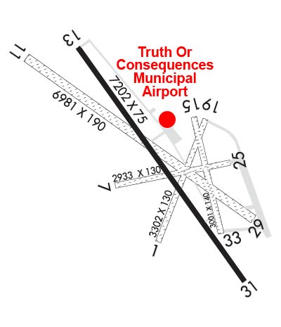
| Lat: N 3314.1 Long: W 10716.2 Elev: 4862 Var: -13 Longest Runway: 7202 | ||
| CTAF: 122.8 | ||
| |||||||||||||||||||||||||||||||||||||||||||||||||||||||||||||
| |||||||||||||||||||||||||||||||||||||||||||||||||||||||||||||
| |||||||||||||||||||||||||||||||||||||||||||||||||||||||||||||
| Rwy | Rwy | |||||||
| 3302x130 | 3302' | 3302x130 | 3302' | |||||
| 2933x130 | 2933' | 2933x130 | 2933' | |||||
| 6981x190 | 6981' | 6981x190 | 6981' | |||||
| 7202x75 | 7202' | 7202x75 | 7202' | |||||
| 3001x140 | 3001' | 3001x140 | 3001' | |||||
| Runway ID | Single Wheel | Double Wheel | Double Tandem Wheel | Dual Double Wheel |
| 01/19 | 410,000 | 595,000 | N/A | N/A |
| 07/25 | N/A | N/A | N/A | N/A |
| 11/29 | N/A | N/A | N/A | N/A |
| 13/31 | 41,000 | 595,000 | N/A | N/A |
| 15/33 | N/A | N/A | N/A | N/A |
| These numbers are Advisory and are not limits. The Airport Manager should have more accurate Weight Limits | ||||
 Airport Diagram might not be current. | |
| Facility Name: | TRUTH OR CONSEQUENCES MUNI |
| City Name: | TRUTH OR CONSEQUENCES |
| County: | SIERRA |
| State abbrev: | NM |
| State Name: | NEW MEXICO |
| Ownership: | PUBLICLY OWNED |
| Use: | OPEN TO THE PUBLIC |
| Owner's Name: | CITY OF TRUTH OR CONSEQUENCES |
| Address: | 505 SIMS |
| TRUTH OR CONSEQUENCE, NM 87901 | |
| Owner's Phone: | 575-894-6673 |
| Manager's Name: | CHAD ROSACKER |
| Address: | 505 SIMS |
| TRUTH OR CONSEQUENCE, NM 87901 | |
| Phone: | 575-894-6199 |
| FAA Region: | SOUTHWEST |
| FAA Field Office: | LNM |

| Date | Sunrise | Sunset |
|---|---|---|
| 06/08/26 Monday | 5:59 | 20:17 |
| 06/09/26 Tuesday | 5:59 | 20:17 |
| 06/10/26 Wednesday | 5:59 | 20:18 |
| 06/11/26 Thursday | 5:59 | 20:18 |
| 06/12/26 Friday | 5:59 | 20:19 |
| 06/13/26 Saturday | 5:59 | 20:19 |
| 06/14/26 Sunday | 5:59 | 20:19 |
| 06/15/26 Monday | 5:59 | 20:20 |
| 06/16/26 Tuesday | 5:59 | 20:20 |
| 06/17/26 Wednesday | 6:00 | 20:20 |
| 06/18/26 Thursday | 6:00 | 20:21 |
| 06/19/26 Friday | 6:00 | 20:21 |
| 06/20/26 Saturday | 6:00 | 20:21 |
| 06/21/26 Sunday | 6:00 | 20:21 |
| Airport Attendance Schedule | 7 Days A Week 0800-1600 |
| Airport Status | OPERATIONAL (This Status can change at any time - please check NOTAMS) |
| Airport Lighting Schedule | DUSK-DAWN: ACTVT MIRL RWY 13/31 - CTAF. |
| Airport Storage Available | Tie Downs, Hanger |
| Extra Services Available | NONE |
| Wind Indicator | YES - (lighted) |
| Control Tower | NO |
| CTAF Frequency | 122.800 |
| Unicom Frequency | 122.800 |
| Rotating Beacon Color | WG |
| Segmented Circle | NO |
| Landing Fee | NO |
| Airport Inspected | STATE - performed by PRIVATE CONTRACT PERSONNEL |
| Inspection Date | 04/08/2026 |
| Type of Fuel Available | Grade 100LL, JET A-1 (icing inhibitor, freeze point -50C) |
| Airframe Repair Service | None |
| Power Plant Repair Service | None |
| Latitude | N3314.1 |
| Longitude | W10716.2 (ESTIMATED) |
| Arpt Elevation | 4861ft (SURVEYED) |
| Magnetic Variation | 13E |
| 6 miles N | of TRUTH OR CONSEQUENCES |
| Traffic Pattern Altitude | |
| Sectional Chart | ALBUQUERQUE |
| Operations (Reported) | Yearly | Avg. Daily |
|---|---|---|
| General Aviation Transient | 0 | 0 |
| General Aviation Local | 0 | 0 |
| Air Taxi | 0 | 0 |
| Commerical | 0 | 0 |
| Commuter | 0 | 0 |
| Military | 0 | 0 |
| Aircraft based on Field | |
|---|---|
| General Aviation Singles | 0 |
| General Aviation Multi | 0 |
| Jet Aircraft | 0 |
| General Aviation Helicopters | 0 |
| Military Aircraft | 0 |
| Gliders | 0 |
| Ultralights | 0 |
| FSS on field | NO |
| FSS tie-in | ALBUQUERQUE |
| FSS Phone | 1-800-WX-BRIEF |
| Who issues Notams | TCS |
| Notam D service at airport | YES |
| ARTCC Name | ALBUQUERQUE |
| Airport Certification | |
| Aircraft Rescue & Firefighting Index | None |
| Airport of Entry | No |
| Custom Landing Rights | No |
| Joint Civil/Military | No |
| Military Landing rights | YES |
| NATIONAL PLAN OF INTEGRATED AIRPORT SYSTEMS (NPIAS) |
| GRANT AGREEMENTS UNDER FAAP/ADAP/AIP |
| CONVEYANCE UNDER SCETION 16, FEDERAL AIRPORT ACT OF 1946 OR SECTION 23, AIRPORT AND AIRWAY DEVELOPMENT ACT OF 1970 |
| ASSURANCES PURSUANT TO TITLE VI, CIVIL RIGHTS ACT OF 1964 |
| ULTRALIGHT OPS WI 5 NM. |
| 1 FT GRAVEL BERMS ALG EDGES OF ALL GRAVEL RYS. |
| FOR CD IF UNA TO CTC ON FSS FREQ, CTC ALBUQUERQUE ARTCC AT 505-856-4561. |
| FUEL AFT HR - AMGR. |
| RWY 01 SHARP DROP OFFS APCH END. |
| RWY 07 SHARP DROP OFFS APCH END. |
Airport Communications & Frequencies:
| |||||||||
| Runway: 01 | Runway: 19 | ||
| Mag heading: | 8° | Mag heading: | 188° |
| Rwy Slope: | .17% Up | Rwy Slope: | -.17% Down |
| Approach: | Approach: | ||
| Pattern: | Left Traffic | Pattern: | Left Traffic |
| Markings: | Markings: | ||
| Marking Condition: | Marking Condition: | ||
| Arresting Dev: | Arresting Dev: | ||
| Lat & Long: | N3313.8 W10716.2 | Lat. & Long.: | N3314.3 W10716.0 |
| Elev: | 4812.5 ft. MSL | Elev: | 4818.0 ft. MSL |
| TCH: | TCH: | ||
| Visual Glide Path: | Visual Glide Path: | ||
| Displaced Threshold: | No | Displaced Threshold: | No |
| Touchdown Zone: | YES | Touchdown Zone: | YES |
| Touchdown Elev.: | 4819.1 feet | Touchdown Elev.: | 4819.1 feet |
| Visual Glide Slope: | Visual Glide Slope: | ||
| RVR Equipment: | RVR Equipment: | ||
| RVV Equipment: | NO | RVV Equipment: | NO |
| Approach Lights: | Approach Lights: | ||
| REIL: | NO | REIL: | NO |
| Centerline Lights: | NO | Centerline Lights: | NO |
| Touchdown lights: | NO | Touchdown lights: | NO |
| Runway Category: | Runway with a Visual Approach | Runway Category: | Runway with a Visual Approach |
| Declared Distances: | Declared Distances: | ||
| Obstructions: | Obstructions: | ROAD | |
| Marked: | Marked: | NOT Marked/Lighted | |
| Clearance slope: | 50:1 | Clearance slope: | 6:1 |
| Obstruction height: | Obstruction height: | 15 feet AGL | |
| Dist. from runway: | Dist. from runway: | 90 feet | |
| Centerline offset: | Centerline offset: | ||
| Comments: | Comments: |
| Runway: 07 | Runway: 25 | ||
| Mag heading: | 66° | Mag heading: | 246° |
| Rwy Slope: | -.68% Down | Rwy Slope: | .68% Up |
| Approach: | Approach: | ||
| Pattern: | Left Traffic | Pattern: | Left Traffic |
| Markings: | Markings: | ||
| Marking Condition: | Marking Condition: | ||
| Arresting Dev: | Arresting Dev: | ||
| Lat & Long: | N3314.0 W10716.4 | Lat. & Long.: | N3314.1 W10715.9 |
| Elev: | 4828.5 ft. MSL | Elev: | 4808.7 ft. MSL |
| TCH: | TCH: | ||
| Visual Glide Path: | Visual Glide Path: | ||
| Displaced Threshold: | No | Displaced Threshold: | No |
| Touchdown Zone: | YES | Touchdown Zone: | YES |
| Touchdown Elev.: | 4828.5 feet | Touchdown Elev.: | 4828.5 feet |
| Visual Glide Slope: | Visual Glide Slope: | ||
| RVR Equipment: | RVR Equipment: | ||
| RVV Equipment: | NO | RVV Equipment: | NO |
| Approach Lights: | Approach Lights: | ||
| REIL: | NO | REIL: | NO |
| Centerline Lights: | NO | Centerline Lights: | NO |
| Touchdown lights: | NO | Touchdown lights: | NO |
| Runway Category: | Runway with a Visual Approach | Runway Category: | Runway with a Visual Approach |
| Declared Distances: | Declared Distances: | ||
| Obstructions: | Obstructions: | ROAD | |
| Marked: | Marked: | NOT Marked/Lighted | |
| Clearance slope: | 50:1 | Clearance slope: | |
| Obstruction height: | Obstruction height: | 10 feet AGL | |
| Dist. from runway: | Dist. from runway: | 0 feet | |
| Centerline offset: | Centerline offset: | ||
| Comments: | Comments: |
| Runway: 11 | Runway: 29 | ||
| Mag heading: | 112° | Mag heading: | 292° |
| Rwy Slope: | -.90% Down | Rwy Slope: | .90% Up |
| Approach: | Approach: | ||
| Pattern: | Left Traffic | Pattern: | Left Traffic |
| Markings: | Markings: | ||
| Marking Condition: | Marking Condition: | ||
| Arresting Dev: | Arresting Dev: | ||
| Lat & Long: | N3314.5 W10716.9 | Lat. & Long.: | N3313.9 W10715.8 |
| Elev: | 4861.9 ft. MSL | Elev: | 4799.3 ft. MSL |
| TCH: | TCH: | ||
| Visual Glide Path: | Visual Glide Path: | ||
| Displaced Threshold: | No | Displaced Threshold: | No |
| Touchdown Zone: | YES | Touchdown Zone: | YES |
| Touchdown Elev.: | 4861.9 feet | Touchdown Elev.: | 4826.9 feet |
| Visual Glide Slope: | Visual Glide Slope: | ||
| RVR Equipment: | RVR Equipment: | ||
| RVV Equipment: | NO | RVV Equipment: | NO |
| Approach Lights: | Approach Lights: | ||
| REIL: | NO | REIL: | NO |
| Centerline Lights: | NO | Centerline Lights: | NO |
| Touchdown lights: | NO | Touchdown lights: | NO |
| Runway Category: | Runway with a Visual Approach | Runway Category: | Runway with a Visual Approach |
| Declared Distances: | Declared Distances: | ||
| Obstructions: | FENCE | Obstructions: | BRUSH |
| Marked: | MARKED | Marked: | NOT Marked/Lighted |
| Clearance slope: | CTLG OBSTN EXCEEDS 45 DEG SLOPE. | Clearance slope: | |
| Obstruction height: | 4 feet AGL | Obstruction height: | 6 feet AGL |
| Dist. from runway: | 0 feet | Dist. from runway: | 0 feet |
| Centerline offset: | Centerline offset: | ||
| Comments: | Comments: |
| Runway: 13 | Runway: 31 | ||
| Mag heading: | 132° | Mag heading: | 312° |
| Rwy Slope: | -.81% Down | Rwy Slope: | .81% Up |
| Approach: | Approach: | ||
| Pattern: | Left Traffic | Pattern: | Left Traffic |
| Markings: | NONPRECISION INSTRUMENT | Markings: | NONPRECISION INSTRUMENT |
| Marking Condition: | GOOD | Marking Condition: | GOOD |
| Arresting Dev: | Arresting Dev: | ||
| Lat & Long: | N3314.6 W10716.6 | Lat. & Long.: | N3313.6 W10715.8 |
| Elev: | 4852.6 ft. MSL | Elev: | 4794.1 ft. MSL |
| TCH: | 40 ft. AGL | TCH: | 40 ft. AGL |
| Visual Glide Path: | 3.00 degrees | Visual Glide Path: | 3.00 degrees |
| Displaced Threshold: | No | Displaced Threshold: | No |
| Touchdown Zone: | YES | Touchdown Zone: | YES |
| Touchdown Elev.: | 4852.6 feet | Touchdown Elev.: | 4820.2 feet |
| Visual Glide Slope: | 2-Light PAPI on LEFT side of Runway | Visual Glide Slope: | 2-Light PAPI on LEFT side of Runway |
| RVR Equipment: | RVR Equipment: | ||
| RVV Equipment: | NO | RVV Equipment: | NO |
| Approach Lights: | Approach Lights: | ||
| REIL: | NO | REIL: | NO |
| Centerline Lights: | NO | Centerline Lights: | NO |
| Touchdown lights: | NO | Touchdown lights: | NO |
| Runway Category: | Runway with a Visual Approach | Runway Category: | Runway with a Visual Approach |
| Declared Distances: | Declared Distances: |
| Runway: 15 | Runway: 33 | ||
| Mag heading: | 154° | Mag heading: | 334° |
| Rwy Slope: | -.60% Down | Rwy Slope: | .60% Up |
| Approach: | Approach: | ||
| Pattern: | Left Traffic | Pattern: | Left Traffic |
| Markings: | Markings: | ||
| Marking Condition: | Marking Condition: | ||
| Arresting Dev: | Arresting Dev: | ||
| Lat & Long: | N3314.3 W10716.1 | Lat. & Long.: | N3313.8 W10715.9 |
| Elev: | 4821.0 ft. MSL | Elev: | 4802.9 ft. MSL |
| TCH: | TCH: | ||
| Visual Glide Path: | Visual Glide Path: | ||
| Displaced Threshold: | No | Displaced Threshold: | No |
| Touchdown Zone: | YES | Touchdown Zone: | YES |
| Touchdown Elev.: | 4821.0 feet | Touchdown Elev.: | 4821.0 feet |
| Visual Glide Slope: | Visual Glide Slope: | ||
| RVR Equipment: | RVR Equipment: | ||
| RVV Equipment: | NO | RVV Equipment: | NO |
| Approach Lights: | Approach Lights: | ||
| REIL: | NO | REIL: | NO |
| Centerline Lights: | NO | Centerline Lights: | NO |
| Touchdown lights: | NO | Touchdown lights: | NO |
| Runway Category: | Runway with a Visual Approach | Runway Category: | Runway with a Visual Approach |
| Declared Distances: | Declared Distances: | ||
| Obstructions: | ROAD | Obstructions: | |
| Marked: | NOT Marked/Lighted | Marked: | |
| Clearance slope: | 3:1 | Clearance slope: | 20:1 |
| Obstruction height: | 15 feet AGL | Obstruction height: | |
| Dist. from runway: | 45 feet | Dist. from runway: | |
| Centerline offset: | Centerline offset: | ||
| Comments: | Comments: |
Thanks for using FltPlan.com
all rights reserved © 1999-2026 by Flight Plan LLC
