
| TAUNTON MUNI - KING FIELD TAUNTON MA |
| |
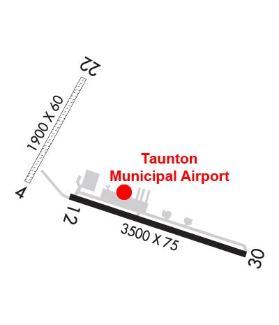
| Lat: N 4152.4 Long: W 07100.9 Elev: 41 Var: +16 Longest Runway: 3499 | ||
| AWOS: 132.67 CTAF: 122.7 | ||
| ||||||||||||||||||||||||||||||||||||||||||||
| ||||||||||||||||||||||||||||||||||||||||||||
| ||||||||||||||||||||||||||||||||||||||||||||
| Rwy | Rwy | |||||||
| 1034x60 | 1034' | 1034x60 | 1034' | |||||
| 3499x75 | 3499' | 3499x75 | 3499' | |||||
| Runway ID | Single Wheel | Double Wheel | Double Tandem Wheel | Dual Double Wheel |
| 04/22 | N/A | N/A | N/A | N/A |
| 12/30 | 45,000 | 73,000 | 129,000 | N/A |
| These numbers are Advisory and are not limits. The Airport Manager should have more accurate Weight Limits | ||||
 Airport Diagram might not be current. | |
| Facility Name: | TAUNTON MUNI/KING FLD |
| City Name: | TAUNTON |
| County: | BRISTOL |
| State abbrev: | MA |
| State Name: | MASSACHUSETTS |
| Ownership: | PUBLICLY OWNED |
| Use: | OPEN TO THE PUBLIC |
| Owner's Name: | CITY OF TAUNTON |
| Address: | CITY HALL, 15 SUMMER ST |
| TAUNTON, MA 02780 | |
| Owner's Phone: | 508-821-1000 |
| Manager's Name: | JAY D' ESPINOSA |
| Address: | 4 WESTCOAT |
| EAST TAUNTON, MA 02718 | |
| Phone: | 508-821-2973 |
| FAA Region: | NEW ENGLAND |
| FAA Field Office: | NONE |
| Date | Sunrise | Sunset |
|---|---|---|
| 06/07/26 Sunday | 5:09 | 20:17 |
| 06/08/26 Monday | 5:09 | 20:17 |
| 06/09/26 Tuesday | 5:09 | 20:18 |
| 06/10/26 Wednesday | 5:09 | 20:18 |
| 06/11/26 Thursday | 5:08 | 20:19 |
| 06/12/26 Friday | 5:08 | 20:19 |
| 06/13/26 Saturday | 5:08 | 20:20 |
| 06/14/26 Sunday | 5:08 | 20:20 |
| 06/15/26 Monday | 5:08 | 20:21 |
| 06/16/26 Tuesday | 5:08 | 20:21 |
| 06/17/26 Wednesday | 5:08 | 20:22 |
| 06/18/26 Thursday | 5:08 | 20:22 |
| 06/19/26 Friday | 5:09 | 20:22 |
| 06/20/26 Saturday | 5:09 | 20:22 |
| Airport Attendance Schedule | 7 Days A Week 0600 - 1400 |
| Airport Status | OPERATIONAL (This Status can change at any time - please check NOTAMS) |
| Airport Lighting Schedule | ACTVT PAPI RWY 30; MIRL RWY 12/30; LGTD WINDSOCK - CTAF. |
| Airport Storage Available | Tie Downs |
| Extra Services Available | Flight Instruction |
| Wind Indicator | YES - (lighted) |
| Control Tower | NO |
| CTAF Frequency | 122.700 |
| Unicom Frequency | 122.700 |
| Rotating Beacon Color | WG |
| Segmented Circle | YES |
| Landing Fee | NO |
| Airport Inspected | STATE - performed by STATE AERONAUTICAL PERSONNEL |
| Inspection Date | 12/28/2023 |
| Type of Fuel Available | Grade 100LL |
| Airframe Repair Service | MAJOR |
| Power Plant Repair Service | MAJOR |
| Latitude | N4152.4 |
| Longitude | W07100.9 (ESTIMATED) |
| Arpt Elevation | 41ft (SURVEYED) |
| Magnetic Variation | 16W |
| 3 miles E | of TAUNTON |
| Traffic Pattern Altitude | |
| Sectional Chart | NEW YORK |
| Operations (Reported) | Yearly | Avg. Daily |
|---|---|---|
| General Aviation Transient | 0 | 0 |
| General Aviation Local | 0 | 0 |
| Air Taxi | 0 | 0 |
| Commerical | 0 | 0 |
| Commuter | 0 | 0 |
| Military | 0 | 0 |
| Aircraft based on Field | |
|---|---|
| General Aviation Singles | 0 |
| General Aviation Multi | 0 |
| Jet Aircraft | 0 |
| General Aviation Helicopters | 0 |
| Military Aircraft | 0 |
| Gliders | 0 |
| Ultralights | 0 |
| FSS on field | NO |
| FSS tie-in | BRIDGEPORT |
| FSS Phone | 1-800-WX-BRIEF |
| Who issues Notams | TAN |
| Notam D service at airport | YES |
| ARTCC Name | BOSTON |
| Airport Certification | |
| Aircraft Rescue & Firefighting Index | None |
| Airport of Entry | No |
| Custom Landing Rights | No |
| Joint Civil/Military | No |
| Military Landing rights | YES |
| NATIONAL PLAN OF INTEGRATED AIRPORT SYSTEMS (NPIAS) |
| GRANT AGREEMENTS UNDER FAAP/ADAP/AIP |
| ASSURANCES PURSUANT TO TITLE VI, CIVIL RIGHTS ACT OF 1964 |
| AVOID FLYING OVR THE ELEMENTARY SCHOOL AT DER 30. |
| HEL AVOID OVERFLIGHT OF DENSELY POPULATED AREAS W & S OF ARPT. |
| CAUTION WILDLIFE, DEER & GEESE ON AND INVOF ARPT AND RWYS. |
| FOR CD CTC PROVIDENCE APCH AT 401-738-8945, WHEN APCH CLSD CTC BOSTON ARTCC AT 603-879-6859. |
| RWY 04/2 2 SFC ROUGH & LOOSE STONES. |
| RWY 12/3 0 PCR VALUE: 150/F/B/X/T |
Airport Communications & Frequencies:
| |||||||||||||||||
| Runway: 04 | Runway: 22 | ||
| Mag heading: | 43° | Mag heading: | 223° |
| Rwy Slope: | .20% Up | Rwy Slope: | -.20% Down |
| Approach: | Approach: | ||
| Pattern: | Left Traffic | Pattern: | Left Traffic |
| Markings: | Markings: | ||
| Marking Condition: | Marking Condition: | ||
| Arresting Dev: | Arresting Dev: | ||
| Lat & Long: | N4152.7 W07101.3 | Lat. & Long.: | N4152.8 W07101.2 |
| Elev: | 23.6 ft. MSL | Elev: | 25.7 ft. MSL |
| TCH: | TCH: | ||
| Visual Glide Path: | Visual Glide Path: | ||
| Displaced Threshold: | No | Displaced Threshold: | No |
| Touchdown Zone: | YES | Touchdown Zone: | YES |
| Touchdown Elev.: | 25.7 feet | Touchdown Elev.: | 25.7 feet |
| Visual Glide Slope: | Visual Glide Slope: | ||
| RVR Equipment: | RVR Equipment: | ||
| RVV Equipment: | NO | RVV Equipment: | NO |
| Approach Lights: | Approach Lights: | ||
| REIL: | NO | REIL: | NO |
| Centerline Lights: | NO | Centerline Lights: | NO |
| Touchdown lights: | NO | Touchdown lights: | NO |
| Runway Category: | Runway with a Visual Approach | Runway Category: | Runway with a Visual Approach |
| Declared Distances: | Declared Distances: | ||
| Obstructions: | TREES | Obstructions: | TREES |
| Marked: | NOT Marked/Lighted | Marked: | NOT Marked/Lighted |
| Clearance slope: | 12:1 | Clearance slope: | 12:1 |
| Obstruction height: | 60 feet AGL | Obstruction height: | 85 feet AGL |
| Dist. from runway: | 800 feet | Dist. from runway: | 1000 feet |
| Centerline offset: | 125B | Centerline offset: | 125 feet left of centerline |
| Comments: | Comments: |
| Runway: 12 | Runway: 30 | ||
| Mag heading: | 124° | Mag heading: | 304° |
| Rwy Slope: | .18% Up | Rwy Slope: | -.18% Down |
| Approach: | Approach: | ||
| Pattern: | Left Traffic | Pattern: | Left Traffic |
| Markings: | NONPRECISION INSTRUMENT | Markings: | NONPRECISION INSTRUMENT |
| Marking Condition: | GOOD | Marking Condition: | GOOD |
| Arresting Dev: | Arresting Dev: | ||
| Lat & Long: | N4152.4 W07101.2 | Lat. & Long.: | N4152.3 W07100.5 |
| Elev: | 34.9 ft. MSL | Elev: | 41.2 ft. MSL |
| TCH: | TCH: | 45 ft. AGL | |
| Visual Glide Path: | Visual Glide Path: | 4.00 degrees | |
| Displaced Threshold: | No | Displaced Threshold: | No |
| Touchdown Zone: | YES | Touchdown Zone: | YES |
| Touchdown Elev.: | 40.8 feet | Touchdown Elev.: | 41.3 feet |
| Visual Glide Slope: | Visual Glide Slope: | 4-Light PAPI on RIGHT side of Runway | |
| RVR Equipment: | RVR Equipment: | ||
| RVV Equipment: | NO | RVV Equipment: | NO |
| Approach Lights: | Approach Lights: | ||
| REIL: | NO | REIL: | YES |
| Centerline Lights: | NO | Centerline Lights: | NO |
| Touchdown lights: | NO | Touchdown lights: | NO |
| Runway Category: | Runway with a Visual Approach | Runway Category: | Runway with a Non-precision Approach |
| Declared Distances: | Declared Distances: | ||
| Obstructions: | TREES | Obstructions: | TREES |
| Marked: | NOT Marked/Lighted | Marked: | NOT Marked/Lighted |
| Clearance slope: | 34:1 | Clearance slope: | 20:1 |
| Obstruction height: | 23 feet AGL | Obstruction height: | 40 feet AGL |
| Dist. from runway: | 1000 feet | Dist. from runway: | 1075 feet |
| Centerline offset: | 135 right of centerline | Centerline offset: | 125 feet left of centerline |
| Comments: | Comments: |
Thanks for using FltPlan.com
all rights reserved © 1999-2026 by Flight Plan LLC
