
| GILLESPIE COUNTY FREDERICKSBURG TX |
| |
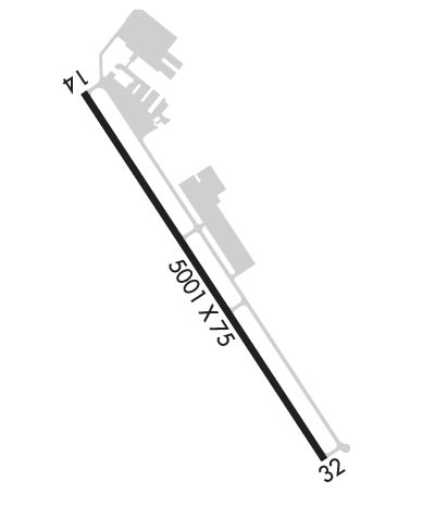
| Lat: N 3014.6 Long: W 09854.6 Elev: 1695 Var: -06 Longest Runway: 5002 | ||
| AWOS: 120.0 CTAF: 122.7 | ||
| ||||||||||||||||||||||||||||||||||||||||||||
| ||||||||||||||||||||||||||||||||||||||||||||
| ||||||||||||||||||||||||||||||||||||||||||||
| Rwy | Rwy | |||||||
| 5002x75 | 5002' | 5002x75 | 5002' | |||||
| Runway ID | Single Wheel | Double Wheel | Double Tandem Wheel | Dual Double Wheel |
| 14/32 | 30,000 | N/A | N/A | N/A |
| These numbers are Advisory and are not limits. The Airport Manager should have more accurate Weight Limits | ||||
 Airport Diagram might not be current. | |
| Facility Name: | GILLESPIE COUNTY |
| City Name: | FREDERICKSBURG |
| County: | GILLESPIE |
| State abbrev: | TX |
| State Name: | TEXAS |
| Ownership: | PUBLICLY OWNED |
| Use: | OPEN TO THE PUBLIC |
| Owner's Name: | GILLESPIE COUNTY |
| Address: | 101 W MAIN |
| FREDERICKSBURG, TX 78624 | |
| Owner's Phone: | 830-997-7502 |
| Manager's Name: | TONY LOMBARDI |
| Address: | 101 W MAIN UNIT 9 |
| FREDERICKSBURG, TX 78624 | |
| Phone: | 830-990-5764 |
| FAA Region: | SOUTHWEST |
| FAA Field Office: | TEX |

| Date | Sunrise | Sunset |
|---|---|---|
| 06/07/26 Sunday | 6:33 | 20:36 |
| 06/08/26 Monday | 6:33 | 20:36 |
| 06/09/26 Tuesday | 6:33 | 20:36 |
| 06/10/26 Wednesday | 6:33 | 20:37 |
| 06/11/26 Thursday | 6:33 | 20:37 |
| 06/12/26 Friday | 6:33 | 20:38 |
| 06/13/26 Saturday | 6:33 | 20:38 |
| 06/14/26 Sunday | 6:33 | 20:38 |
| 06/15/26 Monday | 6:33 | 20:39 |
| 06/16/26 Tuesday | 6:34 | 20:39 |
| 06/17/26 Wednesday | 6:34 | 20:39 |
| 06/18/26 Thursday | 6:34 | 20:40 |
| 06/19/26 Friday | 6:34 | 20:40 |
| 06/20/26 Saturday | 6:34 | 20:40 |
| Airport Attendance Schedule | 7 Days A Week 0800-1800 |
| Airport Status | OPERATIONAL (This Status can change at any time - please check NOTAMS) |
| Airport Lighting Schedule | RWY 14/32 MIRL PRESET LOW INTST; TO INCR INTST ACTVT - CTAF. |
| Airport Storage Available | Tie Downs, Hanger |
| Extra Services Available | Avionics, Flight Instruction, Aircraft Rental |
| Wind Indicator | YES - (lighted) |
| Control Tower | NO |
| CTAF Frequency | 122.700 |
| Unicom Frequency | 122.700 |
| Rotating Beacon Color | WG |
| Segmented Circle | YES |
| Landing Fee | NO |
| Airport Inspected | STATE - performed by PRIVATE CONTRACT PERSONNEL |
| Inspection Date | 01/18/2026 |
| Type of Fuel Available | Grade 100LL, JET A (freeze point -40C); -10FUEL 24 HR SELF SERVE. FULL SERV AVBL DURING ATND HRS. |
| Airframe Repair Service | MAJOR |
| Power Plant Repair Service | MAJOR |
| Latitude | N3014.6 |
| Longitude | W09854.6 (ESTIMATED) |
| Arpt Elevation | 1694ft (SURVEYED) |
| Magnetic Variation | 06E |
| 3 miles SW | of FREDERICKSBURG |
| Traffic Pattern Altitude | |
| Sectional Chart | SAN ANTONIO |
| Operations (Reported) | Yearly | Avg. Daily |
|---|---|---|
| General Aviation Transient | 0 | 0 |
| General Aviation Local | 0 | 0 |
| Air Taxi | 0 | 0 |
| Commerical | 0 | 0 |
| Commuter | 0 | 0 |
| Military | 0 | 0 |
| Aircraft based on Field | |
|---|---|
| General Aviation Singles | 0 |
| General Aviation Multi | 0 |
| Jet Aircraft | 0 |
| General Aviation Helicopters | 0 |
| Military Aircraft | 0 |
| Gliders | 0 |
| Ultralights | 0 |
| FSS on field | NO |
| FSS tie-in | SAN ANGELO |
| FSS Phone | 1-800-WX-BRIEF |
| Who issues Notams | T82 |
| Notam D service at airport | YES |
| ARTCC Name | HOUSTON |
| Airport Certification | |
| Aircraft Rescue & Firefighting Index | None |
| Airport of Entry | No |
| Custom Landing Rights | No |
| Joint Civil/Military | No |
| Military Landing rights | No |
| NATIONAL PLAN OF INTEGRATED AIRPORT SYSTEMS (NPIAS) |
| GRANT AGREEMENT HAS EXPIRED; HOWEVER, AGREEMENT REMAINS IN EFFECT FOR THIS FACILITY AS LONG AS IT IS PUBLIC USE. |
| 75 FT TANK 300 FT SE OF ROTG BCN. |
| FBO 830-997-3313. |
| SEASONAL FFR AIR OPNS IN AND OUT OF ARPT. |
| FOR CD IF UNA VIA GCO CTC HOUSTON ARTCC AT 281-230-5622. |
| VOLUNTARY NOISE ABATEMENT PROCS IN EFFECT; SEE ARPT WEBSITE. AVOID HOUSES 60 DEGS AT .35 NM FROM DEP END RWY 14. |
Airport Communications & Frequencies:
| |||||||||
| Runway: 14 | Runway: 32 | ||
| Mag heading: | 141° | Mag heading: | 321° |
| Rwy Slope: | -.35% Down | Rwy Slope: | .35% Up |
| Approach: | Approach: | ||
| Pattern: | Right Traffic | Pattern: | Left Traffic |
| Markings: | NONPRECISION INSTRUMENT | Markings: | NONPRECISION INSTRUMENT |
| Marking Condition: | FAIR | Marking Condition: | FAIR |
| Arresting Dev: | Arresting Dev: | ||
| Lat & Long: | N3014.9 W09854.8 | Lat. & Long.: | N3014.2 W09854.3 |
| Elev: | 1694.9 ft. MSL | Elev: | 1677.4 ft. MSL |
| TCH: | 43 ft. AGL | TCH: | 37 ft. AGL |
| Visual Glide Path: | 3.00 degrees | Visual Glide Path: | 3.00 degrees |
| Displaced Threshold: | No | Displaced Threshold: | No |
| Touchdown Zone: | YES | Touchdown Zone: | YES |
| Touchdown Elev.: | 1694.9 feet | Touchdown Elev.: | 1684.7 feet |
| Visual Glide Slope: | 2-Light PAPI on LEFT side of Runway | Visual Glide Slope: | 2-Light PAPI on LEFT side of Runway |
| RVR Equipment: | RVR Equipment: | ||
| RVV Equipment: | NO | RVV Equipment: | NO |
| Approach Lights: | Approach Lights: | ||
| REIL: | NO | REIL: | NO |
| Centerline Lights: | NO | Centerline Lights: | NO |
| Touchdown lights: | NO | Touchdown lights: | NO |
| Runway Category: | Runway with a Non-precision Approach having visibility minimums greater than 3/4 mile | Runway Category: | Runway with a Non-precision Approach having visibility minimums greater than 3/4 mile |
| Declared Distances: | Declared Distances: | ||
| Obstructions: | FENCE; ALSO 30 FT TREES 680 FT DSTC ACRS APCH. | Obstructions: | ROAD |
| Marked: | LIGHTED | Marked: | NOT Marked/Lighted |
| Clearance slope: | Clearance slope: | 13:1 | |
| Obstruction height: | 3 feet AGL | Obstruction height: | 12 feet AGL |
| Dist. from runway: | 200 feet | Dist. from runway: | 357 feet |
| Centerline offset: | 216 right of centerline | Centerline offset: | 250 feet right of centerline |
| Comments: | 3 FT FENCE 190-200 FT FM THLD 216 FT RIGHT. | Comments: |
Thanks for using FltPlan.com
all rights reserved © 1999-2026 by Flight Plan LLC