
| ALFRED C 'BUBBA' THOMAS SINTON TX |
| |
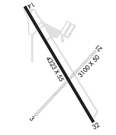
| Lat: N 2802.3 Long: W 09732.6 Elev: 48 Var: -06 Longest Runway: 4323 | ||
| AWOS: 118.25 CTAF: 122.8 | ||
| ||||||
| ||||||
|
| Rwy | Rwy | |||||||
| 3100x50 | 3100' | 3100x50 | 3100' | |||||
| 4323x55 | 4073' | 4323x55 | 3923' | |||||
| Runway ID | Single Wheel | Double Wheel | Double Tandem Wheel | Dual Double Wheel |
| 03/21 | N/A | N/A | N/A | N/A |
| 14/32 | 8,000 | N/A | N/A | N/A |
| These numbers are Advisory and are not limits. The Airport Manager should have more accurate Weight Limits | ||||
 Airport Diagram might not be current. | |
| Facility Name: | ALFRED C 'BUBBA' THOMAS |
| City Name: | SINTON |
| County: | SAN PATRICIO |
| State abbrev: | TX |
| State Name: | TEXAS |
| Ownership: | PUBLICLY OWNED |
| Use: | OPEN TO THE PUBLIC |
| Owner's Name: | SAN PATRICIO COUNTY |
| Address: | SAN PATRICIO COUNTY COURTHOUSE |
| SINTON, TX 78387 | |
| Owner's Phone: | (361) 226-0112 |
| Manager's Name: | GARY LEE DAVIS |
| Address: | 3141 FM 3512 |
| ARANSAS PASS, TX 78336 | |
| Phone: | (361) 226-0112; 317-410-0724 |
| FAA Region: | SOUTHWEST |
| FAA Field Office: | TEX |

| Date | Sunrise | Sunset |
|---|---|---|
| 09/24/21 Friday | 7:19 | 19:25 |
| 09/25/21 Saturday | 7:20 | 19:23 |
| 09/26/21 Sunday | 7:20 | 19:22 |
| 09/27/21 Monday | 7:21 | 19:21 |
| 09/28/21 Tuesday | 7:21 | 19:20 |
| 09/29/21 Wednesday | 7:22 | 19:19 |
| 09/30/21 Thursday | 7:22 | 19:18 |
| 10/01/21 Friday | 7:23 | 19:16 |
| 10/02/21 Saturday | 7:23 | 19:15 |
| 10/03/21 Sunday | 7:24 | 19:14 |
| 10/04/21 Monday | 7:24 | 19:13 |
| 10/05/21 Tuesday | 7:25 | 19:12 |
| 10/06/21 Wednesday | 7:25 | 19:11 |
| 10/07/21 Thursday | 7:26 | 19:10 |
| Airport Attendance Schedule | 7 Days A Week 0730-1700 |
| Airport Status | OPERATIONAL (This Status can change at any time - please check NOTAMS) |
| Airport Lighting Schedule | ACTVT REIL RWY 14 & 32; MIRL RWY 14/32 - CTAF. |
| Airport Storage Available | Tie Downs |
| Extra Services Available | Flight Instruction, Aircraft Rental |
| Wind Indicator | YES - (lighted) |
| Control Tower | NO |
| CTAF Frequency | 122.800 |
| Unicom Frequency | 122.800 |
| Rotating Beacon Color | CLEAR-GREEN (Light Land Airport) |
| Segmented Circle | YES |
| Landing Fee | NO |
| Airport Inspected | STATE - performed by PRIVATE CONTRACT PERSONNEL |
| Inspection Date | 05/04/2020 |
| Type of Fuel Available | Grade 100LL, JET A (freeze point -40C); -10FOR FUEL OR SVC CALL 361-364-3200. AFT HRS CALL 361-548-1483 OR 361-364-2251. |
| Airframe Repair Service | MAJOR |
| Power Plant Repair Service | MAJOR |
| Latitude | N2802.3 |
| Longitude | W09732.6 (ESTIMATED) |
| Arpt Elevation | 47ft (SURVEYED) |
| Magnetic Variation | 06E |
| 2 miles W | of SINTON |
| Traffic Pattern Altitude | |
| Sectional Chart | SAN ANTONIO |
| Operations (Reported) | Yearly | Avg. Daily |
|---|---|---|
| General Aviation Transient | 2000 | 5 |
| General Aviation Local | 1000 | 3 |
| Air Taxi | 0 | 0 |
| Commerical | 0 | 0 |
| Commuter | 0 | 0 |
| Military | 0 | 0 |
| Aircraft based on Field | |
|---|---|
| General Aviation Singles | 28 |
| General Aviation Multi | 11 |
| Jet Aircraft | 0 |
| General Aviation Helicopters | 0 |
| Military Aircraft | 0 |
| Gliders | 0 |
| Ultralights | 0 |
| FSS on field | NO |
| FSS tie-in | SAN ANGELO |
| FSS Phone | 1-800-WX-BRIEF |
| Who issues Notams | SJT |
| Notam D service at airport | YES |
| ARTCC Name | HOUSTON |
| Airport Certification | |
| Aircraft Rescue & Firefighting Index | None |
| Airport of Entry | No |
| Custom Landing Rights | No |
| Joint Civil/Military | No |
| Military Landing rights | No |
| FOR CD CTC CORPUS CHRISTI APCH AT 361-299-4230. |
| RWY 14/32 DSPLCD THR LGTS NONSTD COLORS. |
| RWY 03/2 1 RWY NOT MNTND, CLSD INDEFLY. |
| RWY 03/2 1 1RWY NOT MNTND, UNSUITABLE FOR USE. |
Airport Communications & Frequencies:
| ||||||||||||||
| Runway: 03 | Runway: 21 | ||
| Mag heading: | 35° | Mag heading: | 215° |
| Rwy Slope: | .00% | Rwy Slope: | .00% |
| Approach: | Approach: | ||
| Pattern: | Left Traffic | Pattern: | Left Traffic |
| Markings: | Markings: | ||
| Marking Condition: | Marking Condition: | ||
| Arresting Dev: | Arresting Dev: | ||
| Lat & Long: | N2802.1 W09732.7 | Lat. & Long.: | N2802.5 W09732.4 |
| Elev: | 47.0 ft. MSL | Elev: | 47.0 ft. MSL |
| TCH: | TCH: | ||
| Visual Glide Path: | Visual Glide Path: | ||
| Displaced Threshold: | No | Displaced Threshold: | No |
| Touchdown Zone: | YES | Touchdown Zone: | YES |
| Touchdown Elev.: | 47.0 feet | Touchdown Elev.: | 47.0 feet |
| Visual Glide Slope: | Visual Glide Slope: | ||
| RVR Equipment: | RVR Equipment: | ||
| RVV Equipment: | NO | RVV Equipment: | NO |
| Approach Lights: | Approach Lights: | ||
| REIL: | NO | REIL: | NO |
| Centerline Lights: | NO | Centerline Lights: | NO |
| Touchdown lights: | NO | Touchdown lights: | NO |
| Runway Category: | Runway with a Visual Approach | Runway Category: | Runway with a Visual Approach |
| Declared Distances: | Declared Distances: | ||
| Obstructions: | ROAD | Obstructions: | PLINE |
| Marked: | NOT Marked/Lighted | Marked: | LIGHTED |
| Clearance slope: | 5:1 | Clearance slope: | 11:1 |
| Obstruction height: | 15 feet AGL | Obstruction height: | 35 feet AGL |
| Dist. from runway: | 78 feet | Dist. from runway: | 400 feet |
| Centerline offset: | B | Centerline offset: | |
| Comments: | Comments: |
| Runway: 14 | Runway: 32 | ||
| Mag heading: | 140° | Mag heading: | 320° |
| Rwy Slope: | .01% Up | Rwy Slope: | -.01% Down |
| Approach: | Approach: | ||
| Pattern: | Left Traffic | Pattern: | Left Traffic |
| Markings: | NONPRECISION INSTRUMENT | Markings: | NONPRECISION INSTRUMENT |
| Marking Condition: | GOOD | Marking Condition: | GOOD |
| Arresting Dev: | Arresting Dev: | ||
| Lat & Long: | N2802.6 W09732.8 | Lat. & Long.: | N2802.1 W09732.3 |
| Elev: | 46.2 ft. MSL | Elev: | 46.5 ft. MSL |
| TCH: | 19 ft. AGL | TCH: | 21 ft. AGL |
| Visual Glide Path: | 3.00 degrees | Visual Glide Path: | 3.00 degrees |
| Displaced Threshold: | 250 feet | Displaced Threshold: | 400 feet |
| Touchdown Zone: | YES | Touchdown Zone: | YES |
| Touchdown Elev.: | 47.9 feet | Touchdown Elev.: | 47.6 feet |
| Visual Glide Slope: | 2-Light PAPI on LEFT side of Runway; RWY 14 PAPI OTS INDEFLY. | Visual Glide Slope: | 2-Light PAPI on LEFT side of Runway |
| RVR Equipment: | RVR Equipment: | ||
| RVV Equipment: | NO | RVV Equipment: | NO |
| Approach Lights: | Approach Lights: | ||
| REIL: | YES; REIL OTS INDEFLY. | REIL: | YES |
| Centerline Lights: | NO | Centerline Lights: | NO |
| Touchdown lights: | NO | Touchdown lights: | NO |
| Runway Category: | Runway with a Non-precision Approach | Runway Category: | Runway with a Non-precision Approach |
| Declared Distances: | Declared Distances: | ||
| Obstructions: | ROAD; -25 FT CREEK BED 25 FT FM THR ACRS CNTRLN. | Obstructions: | ROAD |
| Marked: | NOT Marked/Lighted | Marked: | NOT Marked/Lighted |
| Clearance slope: | APCH RATIO 22:1 AT DSPLCD THR OVR 45 FT TREES 994 FT DSTC, 120 FT R. | Clearance slope: | APCH RATIO 30:1 AT DSPLCD THR OVR 30 FT TREES, 9-- FT DSTC. |
| Obstruction height: | 20 feet AGL | Obstruction height: | 15 feet AGL |
| Dist. from runway: | 201 feet | Dist. from runway: | 200 feet |
| Centerline offset: | 195 left of centerline | Centerline offset: | 180 feet right of centerline |
| Comments: | 5 FT FENCE, 107 FT DSTC 235 FT L, 20 FT RD 250 L. | Comments: | 3 FT FENCE AND 15 FT RD 0 FT DSTC, 110 FT L. |
Thanks for using FltPlan.com
all rights reserved © 1999-2021 by Flight Plan LLC