
| PANHANDLE-CARSON COUNTY PANHANDLE TX |
| |
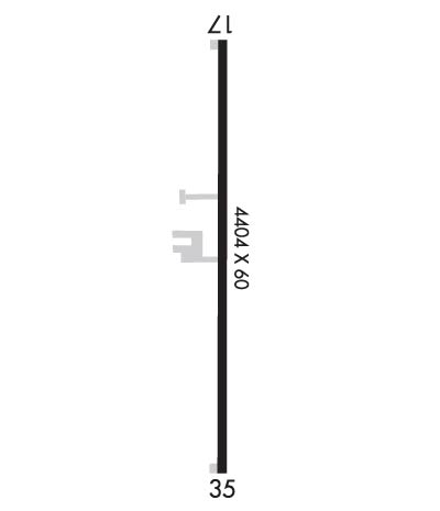
| Lat: N 3521.7 Long: W 10121.9 Elev: 3454 Var: -08 Longest Runway: 4404 | ||
| CTAF: 122.7 | ||
| ||||||
|
| Rwy | Rwy | |||||||
| 4404x60 | 4404' | 4404x60 | 4404' | |||||
| Runway ID | Single Wheel | Double Wheel | Double Tandem Wheel | Dual Double Wheel |
| 17/35 | 12,500 | N/A | N/A | N/A |
| These numbers are Advisory and are not limits. The Airport Manager should have more accurate Weight Limits | ||||
 Airport Diagram might not be current. | |
| Facility Name: | PANHANDLE-CARSON COUNTY |
| City Name: | PANHANDLE |
| County: | CARSON |
| State abbrev: | TX |
| State Name: | TEXAS |
| Ownership: | PUBLICLY OWNED |
| Use: | OPEN TO THE PUBLIC |
| Owner's Name: | CITY OF PANHANDLE & CARSON CO |
| Address: | P.O. BOX 129 |
| PANHANDLE, TX 79068 | |
| Owner's Phone: | 806-537-3517 |
| Manager's Name: | TERRY COFFEE; CITY MANAGER. |
| Address: | P O BOX 129 |
| PANHANDLE, TX 79068 | |
| Phone: | 806-537-3517 |
| FAA Region: | SOUTHWEST |
| FAA Field Office: | TEX |
| Date | Sunrise | Sunset |
|---|---|---|
| 06/12/26 Friday | 6:30 | 21:01 |
| 06/13/26 Saturday | 6:30 | 21:01 |
| 06/14/26 Sunday | 6:30 | 21:02 |
| 06/15/26 Monday | 6:30 | 21:02 |
| 06/16/26 Tuesday | 6:30 | 21:02 |
| 06/17/26 Wednesday | 6:30 | 21:03 |
| 06/18/26 Thursday | 6:30 | 21:03 |
| 06/19/26 Friday | 6:30 | 21:03 |
| 06/20/26 Saturday | 6:31 | 21:03 |
| 06/21/26 Sunday | 6:31 | 21:04 |
| 06/22/26 Monday | 6:31 | 21:04 |
| 06/23/26 Tuesday | 6:31 | 21:04 |
| 06/24/26 Wednesday | 6:32 | 21:04 |
| 06/25/26 Thursday | 6:32 | 21:04 |
| Airport Attendance Schedule | UNATTENDED |
| Airport Status | OPERATIONAL (This Status can change at any time - please check NOTAMS) |
| Airport Lighting Schedule | MIRL RWY 17/35 PRESET LOW INTST; TO INCR INTST ACTVT - 123.5. |
| Airport Storage Available | Tie Downs |
| Extra Services Available | Crop Dusting |
| Wind Indicator | YES - (lighted) |
| Control Tower | NO |
| CTAF Frequency | 122.700 |
| Unicom Frequency | 122.700 |
| Rotating Beacon Color | WG |
| Segmented Circle | YES |
| Landing Fee |
| Airport Inspected | STATE - performed by PRIVATE CONTRACT PERSONNEL |
| Inspection Date | 04/12/2024 |
| Type of Fuel Available | Grade 100LL |
| Airframe Repair Service | None |
| Power Plant Repair Service | None |
| Latitude | N3521.7 |
| Longitude | W10121.9 (ESTIMATED) |
| Arpt Elevation | 3453ft (SURVEYED) |
| Magnetic Variation | 08E |
| 1 miles NE | of PANHANDLE |
| Traffic Pattern Altitude | |
| Sectional Chart | DALLAS-FT WORTH |
| Operations (Reported) | Yearly | Avg. Daily |
|---|---|---|
| General Aviation Transient | 0 | 0 |
| General Aviation Local | 0 | 0 |
| Air Taxi | 0 | 0 |
| Commerical | 0 | 0 |
| Commuter | 0 | 0 |
| Military | 0 | 0 |
| Aircraft based on Field | |
|---|---|
| General Aviation Singles | 0 |
| General Aviation Multi | 0 |
| Jet Aircraft | 0 |
| General Aviation Helicopters | 0 |
| Military Aircraft | 0 |
| Gliders | 0 |
| Ultralights | 0 |
| FSS on field | NO |
| FSS tie-in | FORT WORTH |
| FSS Phone | 1-800-WX-BRIEF |
| Who issues Notams | FTW |
| Notam D service at airport | YES |
| ARTCC Name | ALBUQUERQUE |
| Airport Certification | |
| Aircraft Rescue & Firefighting Index | None |
| Airport of Entry | No |
| Custom Landing Rights | No |
| Joint Civil/Military | No |
| Military Landing rights | No |
| FOR CD CTC ALBUQUERQUE ARTCC AT 505-856-4861. |
Airport Communications & Frequencies:
| |||||||||||||||||
| Runway: 17 | Runway: 35 | ||
| Mag heading: | 172° | Mag heading: | 352° |
| Rwy Slope: | .02% Up | Rwy Slope: | -.02% Down |
| Approach: | Approach: | ||
| Pattern: | Left Traffic | Pattern: | Right Traffic |
| Markings: | NONPRECISION INSTRUMENT | Markings: | NONPRECISION INSTRUMENT |
| Marking Condition: | GOOD | Marking Condition: | GOOD |
| Arresting Dev: | Arresting Dev: | ||
| Lat & Long: | N3522.1 W10121.9 | Lat. & Long.: | N3521.3 W10121.9 |
| Elev: | 3451.0 ft. MSL | Elev: | 3451.9 ft. MSL |
| TCH: | TCH: | ||
| Visual Glide Path: | Visual Glide Path: | ||
| Displaced Threshold: | No | Displaced Threshold: | No |
| Touchdown Zone: | YES | Touchdown Zone: | YES |
| Touchdown Elev.: | 3453.7 feet | Touchdown Elev.: | 3453.5 feet |
| Visual Glide Slope: | Visual Glide Slope: | ||
| RVR Equipment: | RVR Equipment: | ||
| RVV Equipment: | NO | RVV Equipment: | NO |
| Approach Lights: | Approach Lights: | ||
| REIL: | NO | REIL: | NO |
| Centerline Lights: | NO | Centerline Lights: | NO |
| Touchdown lights: | NO | Touchdown lights: | NO |
| Runway Category: | Runway with a Non-precision Approach | Runway Category: | Runway with a Non-precision Approach |
| Declared Distances: | Declared Distances: | ||
| Obstructions: | Obstructions: | ROAD | |
| Marked: | Marked: | NOT Marked/Lighted | |
| Clearance slope: | 20:1 | Clearance slope: | |
| Obstruction height: | Obstruction height: | 15 feet AGL | |
| Dist. from runway: | Dist. from runway: | 201 feet | |
| Centerline offset: | Centerline offset: | 210 feet left of centerline | |
| Comments: | Comments: | 15 FT ROAD, 0-199 FT DSTC, 210 FT L. |
Thanks for using FltPlan.com
all rights reserved © 1999-2026 by Flight Plan LLC
