| LA PORTE MUNI LA PORTE TX |
| |
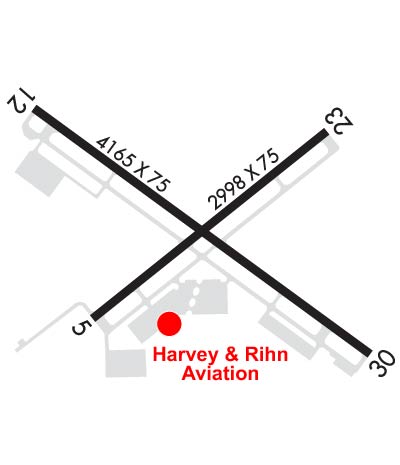
| Lat: N 2940.2 Long: W 09503.9 Elev: 25 Var: -05 Longest Runway: 4165 | ||
| Clr Del: 125.6 AWOS: 120.27 CTAF: 122.7 | ||
| |||||||||||||||||||||||||||||||||||||||
| |||||||||||||||||||||||||||||||||||||||
| |||||||||||||||||||||||||||||||||||||||
| Rwy | Rwy | |||||||
| 2998x75 | 2998' | 2998x75 | 2998' | |||||
| 4165x75 | 3975' | 4165x75 | 3763' | |||||
| Runway ID | Single Wheel | Double Wheel | Double Tandem Wheel | Dual Double Wheel |
| 05/23 | 25,000 | N/A | N/A | N/A |
| 12/30 | 23,000 | N/A | N/A | N/A |
| These numbers are Advisory and are not limits. The Airport Manager should have more accurate Weight Limits | ||||
 Airport Diagram might not be current. | |
| Facility Name: | LA PORTE MUNI |
| City Name: | LA PORTE |
| County: | HARRIS |
| State abbrev: | TX |
| State Name: | TEXAS |
| Ownership: | PUBLICLY OWNED |
| Use: | OPEN TO THE PUBLIC |
| Owner's Name: | CITY OF LA PORTE |
| Address: | 604 W FAIRMONT PKWY |
| LA PORTE, TX 77571 | |
| Owner's Phone: | 281-471-9650 |
| Manager's Name: | DON PENNELL; DIRECTOR OF PUBLIC WORKS. |
| Address: | 2963 N 23RD STREET |
| LA PORTE, TX 77571 | |
| Phone: | (281) 471-9650 |
| FAA Region: | SOUTHWEST |
| FAA Field Office: | TEX |
| Date | Sunrise | Sunset |
|---|---|---|
| 09/24/21 Friday | 7:10 | 19:15 |
| 09/25/21 Saturday | 7:10 | 19:13 |
| 09/26/21 Sunday | 7:11 | 19:12 |
| 09/27/21 Monday | 7:11 | 19:11 |
| 09/28/21 Tuesday | 7:12 | 19:10 |
| 09/29/21 Wednesday | 7:12 | 19:08 |
| 09/30/21 Thursday | 7:13 | 19:07 |
| 10/01/21 Friday | 7:13 | 19:06 |
| 10/02/21 Saturday | 7:14 | 19:05 |
| 10/03/21 Sunday | 7:15 | 19:04 |
| 10/04/21 Monday | 7:15 | 19:02 |
| 10/05/21 Tuesday | 7:16 | 19:01 |
| 10/06/21 Wednesday | 7:16 | 19:00 |
| 10/07/21 Thursday | 7:17 | 18:59 |
| Airport Attendance Schedule | 7 Days A Week DALGT |
| Airport Status | OPERATIONAL (This Status can change at any time - please check NOTAMS) |
| Airport Lighting Schedule | ACTVT REIL RWY 12; PAPI RWY 12; MIRL RWYS 05/23 & 12/30 - CTAF. |
| Airport Storage Available | Tie Downs |
| Extra Services Available | Avionics, Flight Instruction, Aircraft Rental, Aircraft Sales |
| Wind Indicator | YES - (lighted) |
| Control Tower | NO |
| CTAF Frequency | 122.700 |
| Unicom Frequency | 122.700 |
| Rotating Beacon Color | CLEAR-GREEN (Light Land Airport) |
| Segmented Circle | YES |
| Landing Fee | NO |
| Airport Inspected | STATE - performed by PRIVATE CONTRACT PERSONNEL |
| Inspection Date | 02/14/2017 |
| Type of Fuel Available | Grade 100LL, JET A (freeze point -40C); -10FUEL AVBL SELF SERVE 24 HRS. |
| Airframe Repair Service | MAJOR |
| Power Plant Repair Service | MAJOR |
| Latitude | N2940.2 |
| Longitude | W09503.9 (ESTIMATED) |
| Arpt Elevation | 25ft (SURVEYED) |
| Magnetic Variation | 05E |
| 3 miles NW | of LA PORTE |
| Traffic Pattern Altitude | |
| Sectional Chart | HOUSTON |
| Operations (Reported) | Yearly | Avg. Daily |
|---|---|---|
| General Aviation Transient | 9683 | 27 |
| General Aviation Local | 19367 | 53 |
| Air Taxi | 0 | 0 |
| Commerical | 0 | 0 |
| Commuter | 0 | 0 |
| Military | 0 | 0 |
| Aircraft based on Field | |
|---|---|
| General Aviation Singles | 40 |
| General Aviation Multi | 4 |
| Jet Aircraft | 0 |
| General Aviation Helicopters | 0 |
| Military Aircraft | 0 |
| Gliders | 0 |
| Ultralights | 0 |
| FSS on field | NO |
| FSS tie-in | MONTGOMERY COUNTY |
| FSS Phone | 1-800-WX-BRIEF |
| Who issues Notams | CXO |
| Notam D service at airport | YES |
| ARTCC Name | HOUSTON |
| Airport Certification | |
| Aircraft Rescue & Firefighting Index | None |
| Airport of Entry | No |
| Custom Landing Rights | No |
| Joint Civil/Military | No |
| Military Landing rights | YES |
| NATIONAL PLAN OF INTEGRATED AIRPORT SYSTEMS (NPIAS) |
| GRANT AGREEMENTS UNDER FAAP/ADAP/AIP |
| SURPLUS PROPERTY AGREEMENT UNDER PUBLIC LAW 289 |
| ASSURANCES PURSUANT TO TITLE VI, CIVIL RIGHTS ACT OF 1964 |
| THIS AIRPORT HAS BEEN SURVEYED BY THE NATIONAL GEODETIC SURVEY. |
| PAEW ADJ ALL RYS & TWYS. |
| FOR CD CTC HOUSTON APCH AT 281-443-5844. TO CNL IFR CTC HOUSTON APCH AT 281-443-5888. |
Airport Communications & Frequencies:
| ||||||||||||||||
| Runway: 05 | Runway: 23 | ||
| Mag heading: | 46° | Mag heading: | 226° |
| Rwy Slope: | .02% Up | Rwy Slope: | -.02% Down |
| Approach: | Approach: | ||
| Pattern: | Left Traffic | Pattern: | Left Traffic |
| Markings: | BASIC | Markings: | BASIC |
| Marking Condition: | GOOD | Marking Condition: | GOOD |
| Arresting Dev: | Arresting Dev: | ||
| Lat & Long: | N2940.0 W09504.1 | Lat. & Long.: | N2940.3 W09503.6 |
| Elev: | 23.2 ft. MSL | Elev: | 23.7 ft. MSL |
| TCH: | TCH: | ||
| Visual Glide Path: | Visual Glide Path: | ||
| Displaced Threshold: | No | Displaced Threshold: | No |
| Touchdown Zone: | YES | Touchdown Zone: | YES |
| Touchdown Elev.: | 23.7 feet | Touchdown Elev.: | 23.7 feet |
| Visual Glide Slope: | Visual Glide Slope: | ||
| RVR Equipment: | RVR Equipment: | ||
| RVV Equipment: | NO | RVV Equipment: | NO |
| Approach Lights: | Approach Lights: | ||
| REIL: | NO | REIL: | NO |
| Centerline Lights: | NO | Centerline Lights: | NO |
| Touchdown lights: | NO | Touchdown lights: | NO |
| Runway Category: | Runway with a Visual Approach | Runway Category: | Runway with a Visual Approach |
| Declared Distances: | Declared Distances: | ||
| Obstructions: | POLE | Obstructions: | TREES |
| Marked: | MARKED and LIGHTED | Marked: | NOT Marked/Lighted |
| Clearance slope: | 20:1 | Clearance slope: | 15:1 |
| Obstruction height: | 43 feet AGL | Obstruction height: | 36 feet AGL |
| Dist. from runway: | 1060 feet | Dist. from runway: | 760 feet |
| Centerline offset: | 68 right of centerline | Centerline offset: | 155 feet right of centerline |
| Comments: | Comments: |
| Runway: 12 | Runway: 30 | ||
| Mag heading: | 121° | Mag heading: | 301° |
| Rwy Slope: | .00% Down | Rwy Slope: | .00% Up |
| Approach: | Approach: | ||
| Pattern: | Left Traffic | Pattern: | Left Traffic |
| Markings: | NONPRECISION INSTRUMENT | Markings: | NONPRECISION INSTRUMENT |
| Marking Condition: | FAIR | Marking Condition: | FAIR |
| Arresting Dev: | Arresting Dev: | ||
| Lat & Long: | N2940.4 W09504.2 | Lat. & Long.: | N2939.9 W09503.5 |
| Elev: | 24.3 ft. MSL | Elev: | 24.2 ft. MSL |
| TCH: | 47 ft. AGL | TCH: | |
| Visual Glide Path: | 3.00 degrees | Visual Glide Path: | |
| Displaced Threshold: | 190 feet | Displaced Threshold: | 402 feet |
| Touchdown Zone: | YES | Touchdown Zone: | YES |
| Touchdown Elev.: | 25.1 feet | Touchdown Elev.: | 25.1 feet |
| Visual Glide Slope: | 4-Light PAPI on LEFT side of Runway; PAPI RWY 12 UNUSBL BEYOND 8 DEG L OF RWY CNTRLN. | Visual Glide Slope: | |
| RVR Equipment: | RVR Equipment: | ||
| RVV Equipment: | NO | RVV Equipment: | NO |
| Approach Lights: | Approach Lights: | ||
| REIL: | YES | REIL: | NO |
| Centerline Lights: | NO | Centerline Lights: | NO |
| Touchdown lights: | NO | Touchdown lights: | NO |
| Runway Category: | Runway with a Visual Approach | Runway Category: | Runway with a Non-precision Approach |
| Declared Distances: | Declared Distances: | ||
| Obstructions: | TREES | Obstructions: | FENCE |
| Marked: | NOT Marked/Lighted | Marked: | NOT Marked/Lighted |
| Clearance slope: | 17:1; APCH RATIO 34:1 FM DSPLCD THLD OVER 35 FT TREES 1200 FT 250 FT L. | Clearance slope: | APCH RATIO 34:1 FM DSPLCD THLD OVER 22 FT PLINE 748 FT 275 FT R. |
| Obstruction height: | 46 feet AGL | Obstruction height: | 6 feet AGL |
| Dist. from runway: | 997 feet | Dist. from runway: | 201 feet |
| Centerline offset: | 250 right of centerline | Centerline offset: | 236 feet left of centerline |
| Comments: | Comments: | 6 FT FENCE 199 FT FM THLD 246 FT LEFT OF CNTRLN. |
Thanks for using FltPlan.com
all rights reserved © 1999-2021 by Flight Plan LLC