
| AERO COUNTRY MC KINNEY TX |
| |
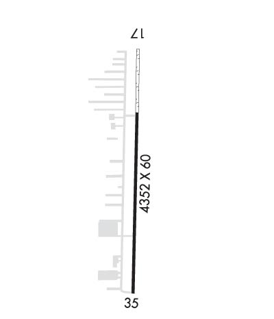
| Lat: N 3312.5 Long: W 09644.5 Elev: 765 Var: -06 Longest Runway: 4352 | ||
| CTAF: 122.9 | ||
| ||||||||||||||||||||||||||||||||||||||||||||
| ||||||||||||||||||||||||||||||||||||||||||||
| Rwy | Rwy | |||||||
| 4352x60 | 4052' | 4352x60 | 4107' | |||||
| Runway ID | Single Wheel | Double Wheel | Double Tandem Wheel | Dual Double Wheel |
| 17/35 | 6,500 | N/A | N/A | N/A |
| These numbers are Advisory and are not limits. The Airport Manager should have more accurate Weight Limits | ||||
| FltPlan does not have IFR approach charts available for KT31. |
 Airport Diagram might not be current. | |
| Facility Name: | AERO COUNTRY |
| City Name: | MC KINNEY |
| County: | COLLIN |
| State abbrev: | TX |
| State Name: | TEXAS |
| Ownership: | PRIVATELY OWNED |
| Use: | OPEN TO THE PUBLIC |
| Owner's Name: | AERO COUNTRY PROPERTY; OWNERS ASSOCIATION. |
| Address: | 235 AERO COUNTRY RD |
| MC KINNEY, TX 75071 | |
| Owner's Phone: | 972-346-8109 |
| Manager's Name: | PRESIDENT ACPOA |
| Address: | 235 AERO COUNTRY RD |
| MC KINNEY, TX 75071 | |
| Phone: | 972-346-8109 |
| FAA Region: | SOUTHWEST |
| FAA Field Office: | TEX |
| Date | Sunrise | Sunset |
|---|---|---|
| 06/07/26 Sunday | 6:18 | 20:34 |
| 06/08/26 Monday | 6:17 | 20:35 |
| 06/09/26 Tuesday | 6:17 | 20:35 |
| 06/10/26 Wednesday | 6:17 | 20:36 |
| 06/11/26 Thursday | 6:17 | 20:36 |
| 06/12/26 Friday | 6:17 | 20:36 |
| 06/13/26 Saturday | 6:17 | 20:37 |
| 06/14/26 Sunday | 6:17 | 20:37 |
| 06/15/26 Monday | 6:17 | 20:38 |
| 06/16/26 Tuesday | 6:17 | 20:38 |
| 06/17/26 Wednesday | 6:17 | 20:38 |
| 06/18/26 Thursday | 6:18 | 20:39 |
| 06/19/26 Friday | 6:18 | 20:39 |
| 06/20/26 Saturday | 6:18 | 20:39 |
| Airport Attendance Schedule | UNATTENDED |
| Airport Status | OPERATIONAL (This Status can change at any time - please check NOTAMS) |
| Airport Lighting Schedule | MIRL RWY 17/35 SS-SR PRESET LOW INTST, TO INCR INTST ACTVT - CTAF. |
| Airport Storage Available | NONE |
| Extra Services Available | Flight Instruction |
| Wind Indicator | YES - (unlit) |
| Control Tower | NO |
| CTAF Frequency | 122.900 |
| Unicom Frequency | |
| Rotating Beacon Color | WG |
| Segmented Circle | NO |
| Landing Fee | NO |
| Airport Inspected | STATE - performed by PRIVATE CONTRACT PERSONNEL |
| Inspection Date | 03/14/2026 |
| Type of Fuel Available | Grade 100LL; -10FUEL 24 HRS SELF-SERVE. |
| Airframe Repair Service | MAJOR |
| Power Plant Repair Service | MAJOR |
| Latitude | N3312.5 |
| Longitude | W09644.5 (ESTIMATED) |
| Arpt Elevation | 765ft (ESTIMATED) |
| Magnetic Variation | 06E |
| 4 miles W | of MC KINNEY |
| Traffic Pattern Altitude | 1035 |
| Sectional Chart | DALLAS-FT WORTH |
| Operations (Reported) | Yearly | Avg. Daily |
|---|---|---|
| General Aviation Transient | 0 | 0 |
| General Aviation Local | 0 | 0 |
| Air Taxi | 0 | 0 |
| Commerical | 0 | 0 |
| Commuter | 0 | 0 |
| Military | 0 | 0 |
| Aircraft based on Field | |
|---|---|
| General Aviation Singles | 0 |
| General Aviation Multi | 0 |
| Jet Aircraft | 0 |
| General Aviation Helicopters | 0 |
| Military Aircraft | 0 |
| Gliders | 0 |
| Ultralights | 0 |
| FSS on field | NO |
| FSS tie-in | FORT WORTH |
| FSS Phone | 1-800-WX-BRIEF |
| Who issues Notams | FTW |
| Notam D service at airport | YES |
| ARTCC Name | FORT WORTH |
| Airport Certification | |
| Aircraft Rescue & Firefighting Index | None |
| Airport of Entry | No |
| Custom Landing Rights | No |
| Joint Civil/Military | No |
| Military Landing rights | No |
| TKOF & LNDG ONLY ON RWY. OTHER AREAS NOT MAINTAINED FOR ACFT OPNS. |
| RWY HOLD SHORT LINES 75 FT FM RWY CNTRLN. |
| 50 FT TREES 125 FT EAST OF RWY CNTRLN, NORTH 1500 FT. |
| FOR CD CTC LONE STAR APCH AT 972-615-2799. |
| ALPHA TWY 20 FT WIDE, TWY TO FUEL SYSTEM 18 FT WIDE. WATCH FOR AUTOS, PEDESTRIANS, SIGNS, AND TRASH CANS ON TWY. |
| CALM WIND RWY 17. |
| NO TSNT PRKG AREA. |
| DUE TO RWY SLOPE, ACFT NOT VSB FM OPPOSITE END OF RWY. |
| STEEP DOWNSLOPE 50 FT EAST OF CNTRLN, SOUTH END. |
| ARPT CLSD TO TSNT FLT TRNG, NO TSNT TGL. |
| RESIDENTIAL AIRPARK, VEHICLES ON TWYS. |
| NOISE SENSITIVE AREAS AROUND ARPT. |
| RWY 17/3 5 RWY 17/35. SOUTH 3000 FT ASPH; NORTH 1500 FT TURF. |
| RWY 17/3 5 ACFT OVER 6500 LBS PROHIBITED. |
| RWY 17/3 5 NSTD MIRL; SOUTH 3000 FT LIGHTED, NORTH 1500 FT UNLIGHTED. |
| RWY 17 1 NO AIMING POINT. |
| Runway: 17 | Runway: 35 | ||
| Mag heading: | N/A | Mag heading: | N/A |
| Approach: | Approach: | ||
| Pattern: | Left Traffic | Pattern: | Left Traffic |
| Markings: | NONPRECISION INSTRUMENT | Markings: | NONPRECISION INSTRUMENT |
| Marking Condition: | GOOD; DTHR MRKD WITH WHITE TIRES EACH SIDE. | Marking Condition: | GOOD; NO AIMING POINT |
| Arresting Dev: | Arresting Dev: | ||
| Lat & Long: | Lat. & Long.: | ||
| Elev: | N/A | Elev: | N/A |
| TCH: | TCH: | ||
| Visual Glide Path: | Visual Glide Path: | ||
| Displaced Threshold: | 300 feet | Displaced Threshold: | 245 feet |
| Touchdown Zone: | NO | Touchdown Zone: | NO |
| Touchdown Elev.: | Touchdown Elev.: | ||
| Visual Glide Slope: | Visual Glide Slope: | ||
| RVR Equipment: | RVR Equipment: | ||
| RVV Equipment: | NO | RVV Equipment: | NO |
| Approach Lights: | Approach Lights: | ||
| REIL: | NO | REIL: | NO |
| Centerline Lights: | NO | Centerline Lights: | NO |
| Touchdown lights: | NO | Touchdown lights: | NO |
| Runway Category: | Runway with a Visual Approach | Runway Category: | Runway with a Visual Approach |
| Declared Distances: | Declared Distances: | ||
| Obstructions: | TREE | Obstructions: | HILL |
| Marked: | NOT Marked/Lighted | Marked: | NOT Marked/Lighted |
| Clearance slope: | APCH SLOPE 0:1 AT DTHR, 34 FT TREES, 0 FT DSTC, 70 FT L. | Clearance slope: | APCH SLOPE 14:1 AT DTHR, 32 FT TREE, 450 FT DSTC, 82 FT R. |
| Obstruction height: | 34 feet AGL | Obstruction height: | 8 feet AGL |
| Dist. from runway: | 0 feet | Dist. from runway: | 201 feet |
| Centerline offset: | Centerline offset: | ||
| Comments: | Comments: | 6 FT FENCE 26 FT DSTC, 125 FT L/R; 15 FT RD, 38 FT DSTC, 135 FT L/R.. |
Thanks for using FltPlan.com
all rights reserved © 1999-2026 by Flight Plan LLC
