
| RESERVE RESERVE NM |
| |
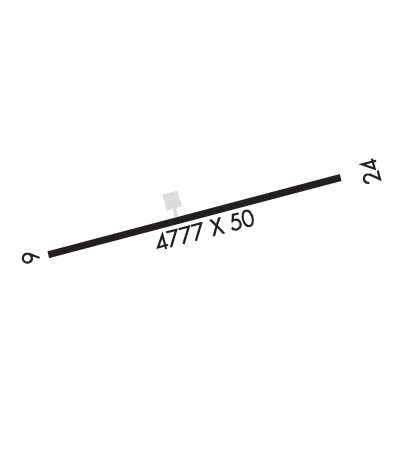
| Lat: N 3341.7 Long: W 10851.0 Elev: 6365 Var: -12 Longest Runway: 4800 | ||
| CTAF: 122.9 | ||
| ||||||||||||||||||||||||||||||||
| ||||||||||||||||||||||||||||||||
| Rwy | Rwy | |||||||
| 4800x50 | 4800' | 4800x50 | 4800' | |||||
| Runway ID | Single Wheel | Double Wheel | Double Tandem Wheel | Dual Double Wheel |
| 07/25 | 12,500 | N/A | N/A | N/A |
| These numbers are Advisory and are not limits. The Airport Manager should have more accurate Weight Limits | ||||
| FltPlan does not have IFR approach charts available for KT16. |
 Airport Diagram might not be current. | |
| Facility Name: | RESERVE |
| City Name: | RESERVE |
| County: | CATRON |
| State abbrev: | NM |
| State Name: | NEW MEXICO |
| Ownership: | PUBLICLY OWNED |
| Use: | OPEN TO THE PUBLIC |
| Owner's Name: | U. S. FOREST SERVICE; LEASED BY CATRON COUNTY. |
| Address: | FEDERAL BUILDING |
| ALBUQUERQUE, NM 87102 | |
| Owner's Phone: | 575-766-2444 |
| Manager's Name: | LINDA COOKE |
| Address: | PO BOX 507 |
| RESERVE, NM 87830 | |
| Phone: | 575-519-9999; EMERGENCY PHONE: (575)533-6423 (BILL GREEN, COUNTY MANAGER) OR CATRON COUNTY SHERIFF'S OFFICE (575-533-6222. |
| FAA Region: | SOUTHWEST |
| FAA Field Office: | LNM |
| Date | Sunrise | Sunset |
|---|---|---|
| 09/24/21 Friday | 7:05 | 19:10 |
| 09/25/21 Saturday | 7:05 | 19:08 |
| 09/26/21 Sunday | 7:06 | 19:07 |
| 09/27/21 Monday | 7:07 | 19:05 |
| 09/28/21 Tuesday | 7:08 | 19:04 |
| 09/29/21 Wednesday | 7:08 | 19:03 |
| 09/30/21 Thursday | 7:09 | 19:01 |
| 10/01/21 Friday | 7:10 | 19:00 |
| 10/02/21 Saturday | 7:10 | 18:59 |
| 10/03/21 Sunday | 7:11 | 18:57 |
| 10/04/21 Monday | 7:12 | 18:56 |
| 10/05/21 Tuesday | 7:13 | 18:55 |
| 10/06/21 Wednesday | 7:13 | 18:53 |
| 10/07/21 Thursday | 7:14 | 18:52 |
| Airport Attendance Schedule | UNATTENDED |
| Airport Status | OPERATIONAL (This Status can change at any time - please check NOTAMS) |
| Airport Lighting Schedule | ACTVT MIRL RWY 07/25 - CTAF. |
| Airport Storage Available | Tie Downs |
| Extra Services Available | NONE |
| Wind Indicator | YES - (lighted) |
| Control Tower | NO |
| CTAF Frequency | 122.900 |
| Unicom Frequency | |
| Rotating Beacon Color | CLEAR-GREEN (Light Land Airport) |
| Segmented Circle | YES |
| Landing Fee | NO |
| Airport Inspected | STATE - performed by PRIVATE CONTRACT PERSONNEL |
| Inspection Date | 03/25/2020 |
| Type of Fuel Available | None |
| Airframe Repair Service | None |
| Power Plant Repair Service | None |
| Latitude | N3341.7 |
| Longitude | W10851.0 (ESTIMATED) |
| Arpt Elevation | 6364ft (ESTIMATED) |
| Magnetic Variation | 12E |
| 5 miles SW | of RESERVE |
| Traffic Pattern Altitude | |
| Sectional Chart | ALBUQUERQUE |
| Operations (Reported) | Yearly | Avg. Daily |
|---|---|---|
| General Aviation Transient | 240 | 1 |
| General Aviation Local | 0 | 0 |
| Air Taxi | 0 | 0 |
| Commerical | 0 | 0 |
| Commuter | 0 | 0 |
| Military | 0 | 0 |
| Aircraft based on Field | |
|---|---|
| General Aviation Singles | 0 |
| General Aviation Multi | 0 |
| Jet Aircraft | 0 |
| General Aviation Helicopters | 0 |
| Military Aircraft | 0 |
| Gliders | 0 |
| Ultralights | 0 |
| FSS on field | NO |
| FSS tie-in | ALBUQUERQUE |
| FSS Phone | 1-800-WX-BRIEF |
| Who issues Notams | ABQ |
| Notam D service at airport | YES |
| ARTCC Name | ALBUQUERQUE |
| Airport Certification | |
| Aircraft Rescue & Firefighting Index | None |
| Airport of Entry | No |
| Custom Landing Rights | No |
| Joint Civil/Military | No |
| Military Landing rights | YES |
| NATIONAL PLAN OF INTEGRATED AIRPORT SYSTEMS (NPIAS) |
| GRANT AGREEMENTS UNDER FAAP/ADAP/AIP |
| ASSURANCES PURSUANT TO TITLE VI, CIVIL RIGHTS ACT OF 1964 |
| RWY 07/25 GRADIENT TWO PERCENT UP WEST. |
| ELK ON & INVOF ARPT; ARPT FENCED. |
| PENETRATION OF TRANS SFC BY TREES BYD BOUNDARY FENCE N & S SIDES OF RY 07/25. |
| OBSTN LGTS ON MTN PEAKS OTS INDEF. |
| AIPORT ACCESS CODE 7360. |
| FOR CD CTC ALBUQUERQUE ARTCC AT 505-856-4861. |
| ARPT CARETAKER ON PROPERTY. |
| Runway: 07 | Runway: 25 | ||
| Mag heading: | 63° | Mag heading: | 243° |
| Rwy Slope: | -1.88% Down | Rwy Slope: | 1.88% Up |
| Approach: | Approach: | ||
| Pattern: | Left Traffic | Pattern: | Left Traffic |
| Markings: | BASIC | Markings: | BASIC |
| Marking Condition: | GOOD | Marking Condition: | GOOD |
| Arresting Dev: | Arresting Dev: | ||
| Lat & Long: | N3341.6 W10851.5 | Lat. & Long.: | N3341.8 W10850.5 |
| Elev: | 6364.7 ft. MSL | Elev: | 6274.3 ft. MSL |
| TCH: | TCH: | 40 ft. AGL | |
| Visual Glide Path: | Visual Glide Path: | 4.00 degrees | |
| Displaced Threshold: | No | Displaced Threshold: | No |
| Touchdown Zone: | NO | Touchdown Zone: | NO |
| Touchdown Elev.: | Touchdown Elev.: | ||
| Visual Glide Slope: | RWY 25 PSIL OTS INDEF. | Visual Glide Slope: | PULSATING/STEADY BURNING VASI ON LEFT SIDE OF RUNWAY |
| RVR Equipment: | RVR Equipment: | ||
| RVV Equipment: | NO | RVV Equipment: | NO |
| Approach Lights: | Approach Lights: | ||
| REIL: | NO | REIL: | NO |
| Centerline Lights: | NO | Centerline Lights: | NO |
| Touchdown lights: | NO | Touchdown lights: | NO |
| Runway Category: | Runway with a Visual Approach | Runway Category: | Runway with a Visual Approach |
| Declared Distances: | Declared Distances: | ||
| Obstructions: | TREE | Obstructions: | TREES |
| Marked: | NOT Marked/Lighted | Marked: | NOT Marked/Lighted |
| Clearance slope: | Clearance slope: | 1:1 | |
| Obstruction height: | 9 feet AGL | Obstruction height: | 4 feet AGL |
| Dist. from runway: | 205 feet | Dist. from runway: | 205 feet |
| Centerline offset: | 85 left of centerline | Centerline offset: | 35 feet right of centerline |
| Comments: | +4-18 FT BRUSH AND TREES 0- 200 FT FM END OF RWY, 80-125 FT LEFT FM CNTRLN. | Comments: | +3-5 FT BRUSH 20-100 FT. FM END OF RWY 120 FT LEFT OF CNTRLN. |
Thanks for using FltPlan.com
all rights reserved © 1999-2021 by Flight Plan LLC
